Partly sunny, with a high near 19. Wind chill values as low as -6. North wind 5 to 10 mph.
Saturday Night
Snow after 1am. Low around 14. Calm wind becoming northeast around 5 mph after midnight. Chance of precipitation is 80%. New snow accumulation of around an inch possible.
Sunday
Snow before 1pm, then snow, freezing rain, and sleet. The snow could be heavy at times. High near 27. Northeast wind 10 to 15 mph, with gusts as high as 30 mph.
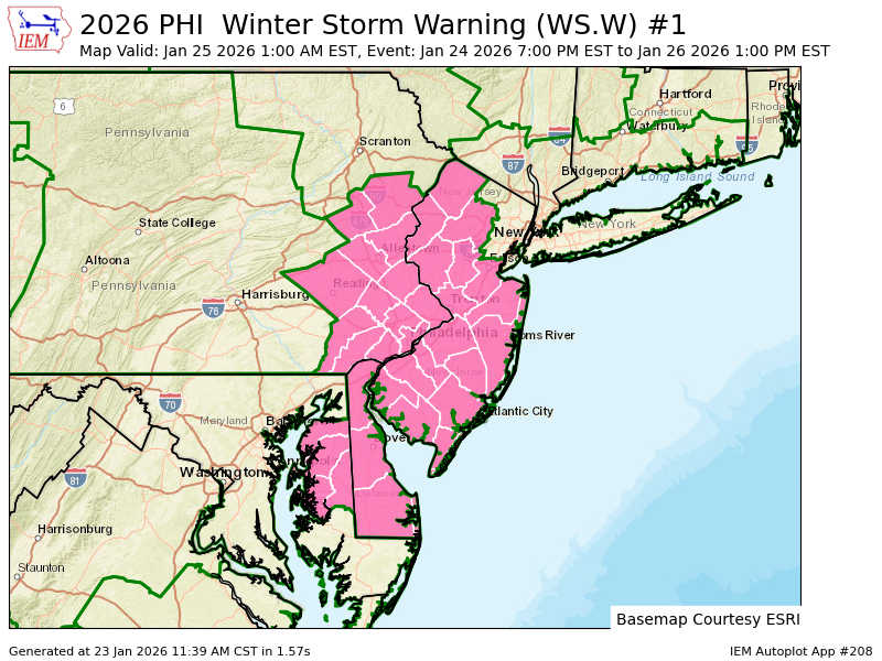
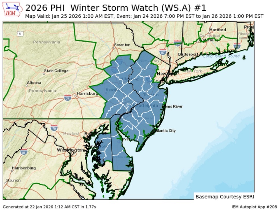
As we have been saying for days now. A significant winter storm expected to impact the Mid-Atlantic from late Saturday into Monday. A Winter Storm Warning is in place for ALL of Pennsylvania and New Jersey, signaling heavy snow, potential mixed precipitation (sleet/freezing rain), and dangerous travel conditions. STAY home on SUNDAY if you can at all cost!
📍 Philadelphia (City & Suburbs)
Snow develops Saturday night and becomes widespread Sunday.
Heavy snow rates possible Sunday, with blowing snow at times due to strong winds.
Travel could become very difficult to impossible, particularly Sunday and Sunday night.
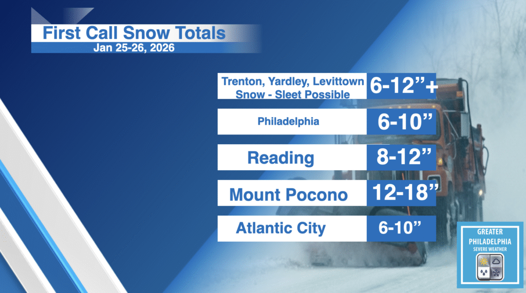
6 to 12 inches of snow possible
📍 Levittown & Bucks County
Snow likely starting after midnight Saturday night and persisting through Sunday.
Forecast models show snow plus some wintry mixing late Sunday, possibly reducing totals slightly but still significant impacts.
A general 8–12 inches likely with some areas seeing well over 12″. Areas along and near I-95 may see totals closer to the higher end
Atlantic City & South Jersey
Snow arrives late Saturday night.
Atlantic City may see higher wind gusts and sleet/rain mixing near the coast, leading to lower snow totals than inland NJ but still hazardous conditions.
Reading, PA
Higher snow amounts likely due to colder inland conditions, with 8-12+ inches possible as snow bands persist longer Sunday.
Impacts to Expect
Travel & Roads
Roads rapidly become snow-covered and slick with blowing/drifting snow.
Sunday and Sunday night expected to be the worst window for travel — avoid non-essential travel if possible.
Power & Trees
Periods of freezing rain/sleet can accumulate on wires and limbs, increasing power outage risk.
Schools & Work
Delays, closures, and remote plans likely Monday morning.
Airports & Transit
Significant flight delays/cancellations are highly possible at PHL, EWR, and ACY.
Charge devices and prepare backup power if possible.
Ensure snow removal tools are ready.
Avoid travel during peak snowfall and check updates frequently.
WINTER STORM WARNINGS ARE IN EFFECT
WINTER STORM WARNING IN EFFECT FROM 7 PM SATURDAY TO 1 PM EST
MONDAY...

* WHAT...Heavy snow with mixed precipitation expected. Total snow
  accumulations between 10 and 15 inches and ice accumulations
  around one tenth of an inch.

* WHERE...Portions of New Jersey and southeast Pennsylvania.

* WHEN...From 7 PM Saturday to 1 PM EST Monday.

* IMPACTS...Travel could be very difficult to impossible. The
  hazardous conditions could impact the Monday morning commute.

PRECAUTIONARY/PREPAREDNESS ACTIONS...

If you must travel, keep an extra flashlight, food, and water in
your vehicle in case of an emergency. The latest road conditions for
the state you are calling from can be obtained by calling 5 1 1.
Have a great Friday! As we been saying all week prepare for major winter storm coming this weekend. We could see over 12” of snow during a long duration event.
Friday
Partly sunny, with a high near 37. West wind 5 to 10 mph increasing to 10 to 15 mph in the afternoon. Winds could gust as high as 30 mph.
Friday Night
Partly cloudy, with a low around 8. Wind chill values as low as -4
Have a great Thursday! all eyes are on the potential for a major winter storm over the weekend appears to start late Saturday night and last through Monday!
Thursday
Increasing clouds, with a high near 44. West wind 10 to 15 mph, with gusts as high as 25 mph.