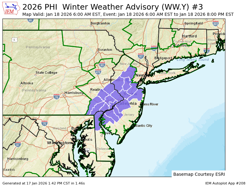
Daily Forecast

Winter Storm Watch has been issued for Sunday 1 AM until 1 PM Monday


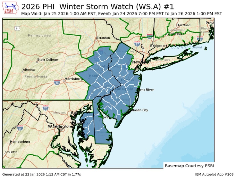
WINTER STORM WATCH IN EFFECT FROM LATE SATURDAY NIGHT THROUGH
MONDAY AFTERNOON...

* WHAT...Heavy snow and significant snow accumulations likely.

* WHERE...Portions of central, northern, northwest, and southern New
Jersey and east central, northeast, and southeast Pennsylvania.

* WHEN...From late Saturday night through Monday afternoon.

* IMPACTS...Plan on slippery road conditions. The hazardous
conditions could impact the Monday morning commute.

PRECAUTIONARY/PREPAREDNESS ACTIONS...

Monitor the latest forecasts for updates on this situation.

Daily Forecast Jan 21, 2026 |


Have a great Thursday! all eyes are on the potential for a major winter storm over the weekend appears to start late Saturday night and last through Monday!

Thursday

Increasing clouds, with a high near 44. West wind 10 to 15 mph, with gusts as high as 25 mph. 

Thursday Night

Partly cloudy, with a low around 23

Daily Forecast Jan 21, 2026 |


Have a great Wednesday! all eyes are on the potential for a major winter storm over the weekend

Wednesday

Increasing clouds, with a high near 34. Light south wind increasing to 10 to 15 mph in the morning. 

Wednesday Night

Cloudy, then gradually becoming partly cloudy, with a low around 29. South wind 5 to 10 mph.

COLD WEATHER ADVISORY IN EFFECT 2am until 10am Tuesday

COLD WEATHER ADVISORY REMAINS IN EFFECT FROM 2 AM TO 10 AM EST
TUESDAY...

* WHAT...Very cold wind chills as low as 5 degrees below zero
  expected.

* WHERE...Portions of central, northern, and northwest New Jersey
  and southeast Pennsylvania.

* WHEN...From 2 AM to 10 AM EST Tuesday.

PRECAUTIONARY/PREPAREDNESS ACTIONS...

Use caution while traveling outside. Wear appropriate clothing, a
hat, and gloves

Winter weather advisory in effect Sunday 6 AM until 8 PM 


WINTER WEATHER ADVISORY IN EFFECT FROM 6 AM TO 8 PM EST SUNDAY...

* WHAT...Snow expected. Total snow accumulations between 1 and 3
inches.

* WHERE...Portions of northern Delaware, southern New Jersey, and
southeast Pennsylvania.

* WHEN...From 6 AM to 8 PM EST Sunday.

* IMPACTS...Plan on slippery road conditions.

* ADDITIONAL DETAILS...Snow may mix with rain for a time at the
onset Sunday morning before becoming all snow by Sunday afternoon.

PRECAUTIONARY/PREPAREDNESS ACTIONS...

Slow down and use caution while traveling. The latest road
conditions for the state you are calling from can be obtained by
calling 5 1 1.

Weekend Forecast Jan 17 and 18, 2026


Have a great weekend!

Saturday

Snow, possibly mixing with rain after 1pm, then gradually ending. High near 40.

Saturday Night

A chance of snow after 1am. Increasing clouds, with a low around 29.

Sunday

A chance of snow. Cloudy, with a high near 35

Sunday Night

Partly cloudy, with a low around 19

Daily Forecast Jan 16, 2026


Have a great Friday!

Friday

Increasing clouds, with a high near 34. West wind 10 to 15 mph, with gusts as high as 30 mph. 

Friday Night

A chance of snow after 1am. Increasing clouds, with a low around 27