Daily Forecast May 18, 2021
Have a great day!
Tuesday
Sunny, with a high near 81. West wind 5 to 10 mph.
Tuesday Night
Mostly clear, with a low around 56.
Have a great day!
Tuesday
Sunny, with a high near 81. West wind 5 to 10 mph.
Tuesday Night
Mostly clear, with a low around 56.
Have a GREAT Monday! Temps later in the week will be around 90º.
Monday
Isolated showers after 2pm. Mostly sunny, with a high near 77.
Monday Night
Mostly clear, with a low around 53
Have a great weekend!
Saturday
A slight chance of showers and thunderstorms after 2pm. Increasing clouds, with a high near 76.
Saturday Night
Partly cloudy, with a low around 52. South wind around 5 mph becoming calm.
Sunday
A slight chance of showers between 11am and 2pm, then a chance of showers and thunderstorms after 2pm. Partly sunny, with a high near 74.
Sunday Night
A chance of showers and thunderstorms, mainly before 8pm. Mostly cloudy, with a low around 52.
Happy Friday!
Friday
Sunny, with a high near 74. North wind around 5 mph becoming calm.
Friday Night
Mostly clear, with a low around 50
PRESS RELEASE FROM COLONIAL PIPELINE
Colonial Pipeline initiated the restart of pipeline operations today at approximately 5 p.m. ET.
Following this restart, it will take several days for the product delivery supply chain to return to normal. Some markets served by Colonial Pipeline may experience, or continue to experience, intermittent service interruptions during the start-up period. Colonial will move as much gasoline, diesel, and jet fuel as is safely possible and will continue to do so until markets return to normal.
As we initiate our return to service, our primary focus remains safety. As part of this startup process, Colonial will conduct a comprehensive series of pipeline safety assessments in compliance with all Federal pipeline safety requirements.
This is the first step in the restart process and would not have been possible without the around-the-clock support of Colonial Pipeline’s dedicated employees who have worked tirelessly to help us achieve this milestone. We would also like to thank the White House for their leadership and collaboration, as well as the Department of Energy, Department of Transportation, FBI, PHMSA, FERC and other federal, state and local agencies for their ongoing support.
We will continue to provide updates as restart efforts progress.
Have a great day!
Thursday
Sunny, with a high near 70. North wind around 5 mph.
Thursday Night
Partly cloudy, with a low around 47.
Have a great day!
Wednesday
Sunny, with a high near 67. Northwest wind around 10 mph, with gusts as high as 20 mph.
Wednesday Night
Mostly clear, with a low around 44
Have a GREAT Day!
Tuesday
Sunny, with a high near 64. West wind 5 to 15 mph.
Tuesday Night
Mostly clear, with a low around 43
Have a great day!
Monday
Mostly sunny, with a high near 66. Northwest wind around 10 mph, with gusts as high as 20 mph.
Monday Night
Partly cloudy, with a low around 45
Press Release issued by NASA:

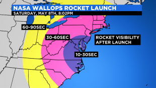
A mission to explore energy transport in space using a NASA suborbital sounding rocket launching May 8, 2021, from NASA’s Wallops Flight Facility in Virginia may provide a brief light show for residents of the eastern United States and Bermuda.
The mission is scheduled for no earlier than 8:02 p.m. EDT with a 40-minute launch window, Saturday, May 8. Backup launch days run through May 16. The launch may be visible, weather permitting, in much of the eastern United States from the Atlantic coast to the Mississippi River.
A four-stage Black Brant XII rocket will be used for the mission that includes the release of barium vapor that will form two green-violet clouds that may be visible for about 30 seconds. The barium vapor is not harmful to the environment or public health
The mission, called the KiNETic-scale energy and momentum transport eXperiment, or KiNet-X, is designed to study a very fundamental problem in space plasmas, namely, how are energy and momentum transported between different regions of space that are magnetically connected?
The vapor will be released approximately 9 minutes and 30 seconds to around 10 minutes after launch at about 217-249 miles altitude over the Atlantic Ocean and 540-560 miles downrange from Wallops and just north of Bermuda.
Immediately after release of the vapor, the spherical clouds are a mixture of green and violet, but that phase only lasts about 30 seconds when the un-ionized component of the cloud has diffused away. After exposure to sunlight the vapor clouds quickly ionize and take on a violet color.
The ionized portion of the cloud becomes tied to the magnetic field lines and diffuses parallel to the field lines but not perpendicular to it. In the mid-Atlantic region latitudes, the field lines are inclined by about 45 degrees to the horizontal, so the violet clouds stretch out in a slanted orientation and look more like short trails than a cloud. Because the motion of the neutral portion of the clouds is not constrained by the magnetic field lines, they spread out more quickly and become too thin to see with the naked eye much sooner than the ionized component.
In general, the human eye does not see violet colors very well in darkness. The KiNET-X clouds will therefore be more difficult for the casual observer to see than some of the previous vapor missions launched from Wallops.
Live coverage of the mission will be available on the Wallops IBM video site (previously Ustream) beginning at 7:40 p.m. on launch day. Launch status updates can be found on the Wallops Facebook and Twitter sites.
The NASA Visitor Center at Wallops will not be open for launch viewing.
Header image: KiNet-X Visibility Map.
Keith Koehler
NASA’s Wallops Flight Facility, Virginia
757-894-4152
[email protected]