Flash Flood Watch in effect until 1pm this afternoon.
Friday Showers and possibly a thunderstorm, mainly before 4pm, then a chance of showers and thunderstorms after 4pm. Some of the storms could produce heavy rainfall. Patchy fog before 10am. High near 81.
Friday Night A chance of showers and thunderstorms. Mostly cloudy, with a low around 68.
We urge everyone to stay home tomorrow late morning to evening. Conditions will worsen as the storm moves up the coast moves up the coast.

We know the information below is a lot, but this key information from the NHC are helpful and very important.
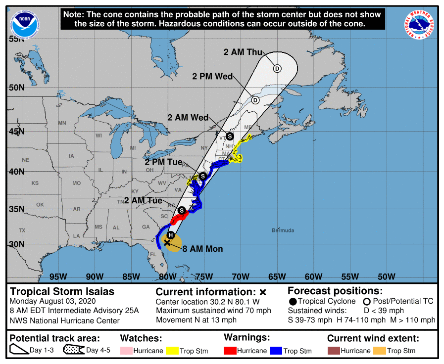
Tropical Storm Isaias is currently located just offshore of the southeast Georgia coast and will continue northward along the East Coast, likely moving inland over the Carolinas this evening. Isaias will approach Delmarva by late tonight and pass through the region on
Tuesday. Impacts will diminish Tuesday night.
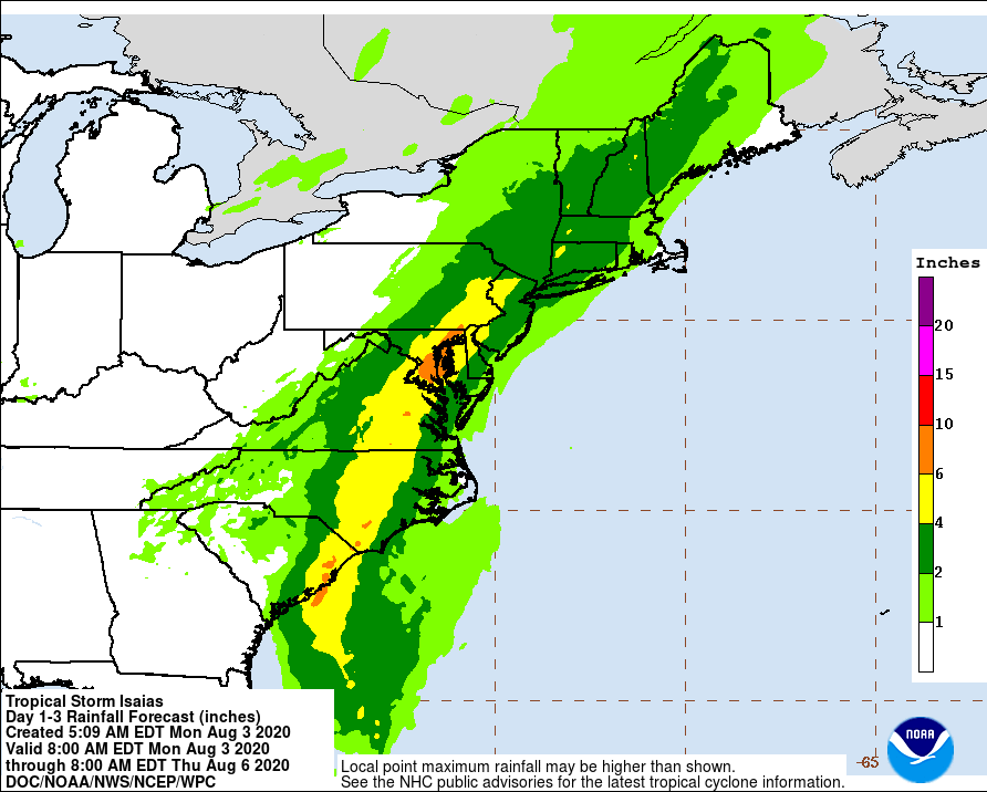
The main threats with this system are heavy rainfall resulting in widespread flash flooding as well as some river flooding, as well as strong and damaging winds, especially near the coast. In addition, minor to potentially moderate coastal flooding, and dangerous marine conditions will occur.
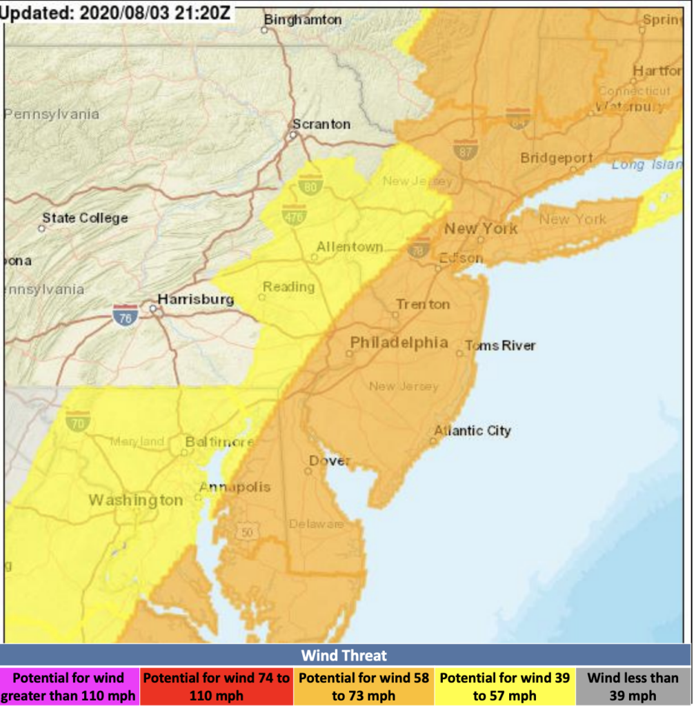
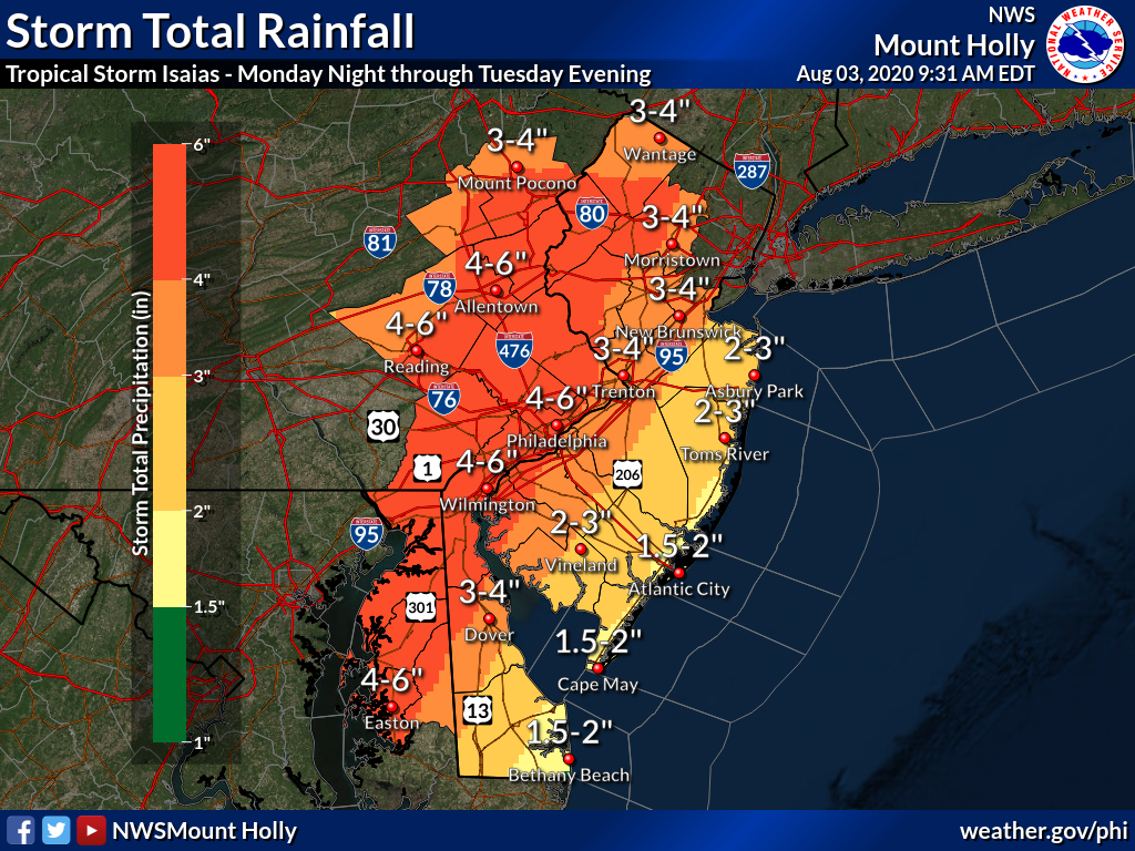
Four to six inches of rain with locally higher amounts will result in flash flooding. Strong winds along the New Jersey and Delaware coasts with wind gusts of 65 to 75 mph are possible, and wind gusts inland will range from 55 to 65 mph. Secondary threats include minor to locally moderate coastal flooding, especially in Chesapeake Bay, as
well as the potential for isolated tornadoes. Dangerous rip currents and 7 to 15 foot seas are also expected over the waters.
POTENTIAL IMPACTS
* FLOODING RAIN: Protect against life-threatening rainfall flooding having possible extensive impacts across Delmarva, western New Jersey, and southeast Pennsylvania. Potential impacts include:
- Major rainfall flooding may prompt many evacuations and rescues.
- Rivers and tributaries may rapidly overflow their banks in multiple places. Small streams, creeks, canals, arroyos, and ditches may become dangerous rivers. In mountain areas, destructive runoff may run quickly down valleys while increasing susceptibility to rockslides and mudslides. Flood control systems and barriers may become stressed.
- Flood waters can enter many structures within multiple communities, some structures becoming uninhabitable or washed away. Many places where flood waters may cover escape routes. Streets and parking lots become rivers of moving water with underpasses submerged. Driving conditions become dangerous. Many road and bridge closures with some weakened or washed out.
Protect against dangerous rainfall flooding having possible significant impacts across coastal New Jersey and Delaware.
* WIND:
Protect against dangerous wind having possible significant impacts across New Jersey, northern Delmarva, and much of southeastern Pennsylvania. Potential impacts in this area include:
- Some damage to roofing and siding materials, along with damage to porches, awnings, carports, and sheds. A few buildings experiencing window, door, and garage door failures. Mobile homes damaged, especially if unanchored. Unsecured lightweight objects become dangerous projectiles.
- Several large trees snapped or uprooted, but with greater numbers in places where trees are shallow rooted. Several fences and roadway signs blown over.
- Some roads impassable from large debris, and more within urban or heavily wooded places. A few bridges, causeways, and access routes impassable.
- Scattered power and communications outages, but more prevalent in areas with above ground lines.
* TORNADOES:
Protect against a tornado event having possible limited impacts across NEW JERSEY...DELAWARE...SOUTHEASTERN PENNSYLVANIA AND NORTHEAST MARYLAND. Potential impacts include:
- The occurrence of isolated tornadoes can hinder the execution of emergency plans during tropical events.
- A few places may experience tornado damage, along with power and communications disruptions.
- Locations could realize roofs peeled off buildings, chimneys toppled, mobile homes pushed off foundations or overturned, large tree tops and branches snapped off, shallow-rooted trees knocked over, moving vehicles blown off roads, and small boats pulled from moorings.
PRECAUTIONARY/PREPAREDNESS ACTIONS
* PREPAREDNESS INFORMATION:
Now is the time to complete all preparations to protect life and property in accordance with your emergency plan. Ensure you are in a safe location before the onset of strong winds or possible flooding.
If heading to a community shelter, become familiar with the shelter rules before arrival, especially if you have special needs or have pets.
Take essential items with you from your Emergency Supplies Kit. Keep cell phones well charged. Cell phone chargers for automobiles can be helpful, but be aware of your risk for deadly carbon monoxide poisoning if your car is left idling in a garage or other poorly ventilated area.
It is important to remain calm, informed, and focused during an emergency. Be patient and helpful with those you encounter.
Rapidly rising flood waters are deadly. If you are in a flood-prone area, consider moving to higher ground. Never drive through a flooded roadway. Remember, turn around don`t drown!
If a Tornado Warning is issued for your area, be ready to shelter quickly, preferably away from windows and in an interior room not prone to flooding. If driving, scan the roadside for quick shelter options. If in a place that is vulnerable to high wind, such as near large trees, a manufactured home, upper floors of a high-rise building, or on a boat, consider moving to a safer shelter before the onset of strong winds or flooding.
Closely monitor weather.gov, NOAA Weather radio or local news outlets for official storm information. Be ready to adapt to possible changes to the forecast. Ensure you have multiple ways to receive weather warnings.
Tuesday Tropical storm conditions possible. Showers and possibly a thunderstorm. Some of the storms could produce heavy rainfall. High near 78. Chance of precipitation is 90%. New rainfall amounts between 1 and 2 inches possible.
Tuesday Night A chance of showers and thunderstorms. Mostly cloudy, with a low around 70. Southwest wind 10 to 15 mph. Chance of precipitation is 50%. New rainfall amounts between 1 and 2 inches possible
CURRENT WATCHS/WARNINGS: FLASH FLOOD WATCH until 12am on Aug 5th. Tropical Storm Watch
ISAIAS FORECAST TO MAKE LANDFALL TONIGHT AS A HURRICANE… …EXPECTED TO BRING STRONG WINDS AND HEAVY RAINFALL FROM THE EASTERN CAROLINAS TO THE MID-ATLANTIC COAST TONIGHT AND TUESDAY…
11:00 AM EDT Mon Aug 3 Location: 30.7°N 80.1°W Moving: N at 13 mph Min pressure: 998 mb Max sustained: 70 mph
Tropical Storm Isaias is currently located just offshore of the northeast Florida coast. The storm is expected to continue northward along the East Coast. It will likely move inland over the Carolinas this evening and approach our region by late tonight and especially Tuesday. Impacts should diminish by Wednesday morning.

The main threats with this system are heavy rainfall leading to flash flooding and some river flooding, strong winds especially near the coast, minor to potentially moderate coastal flooding, and dangerous marine conditions.

We are most concerned about flash flooding caused by 4 to 6 inches of rain, as well as strong winds along the New Jersey and Delaware coasts with wind gusts of 60 to 70 mph possible. Secondary threats include minor to locally moderate coastal flooding, especially in Chesapeake Bay, as well as the potential for isolated tornadoes. Dangerous rip currents and 8 to 12 foot seas are also expected over the waters.
Along the river and ocean expect to see 1 to 3 feet of storm surge inundation along those area. The Philadelphia metro area will have the greatest threat for FLASH FLOODING rain late tonight into tomorrow.
Tornados: The main threat of isolated tornadoes will be during the day hours on Tuesday. The best chance of an isolated tornado will be along/southeast of i95.