Daily Forecast

Tropical Storm Watch ISSUED

Tropical Storm Watch issued for all areas shaded above.
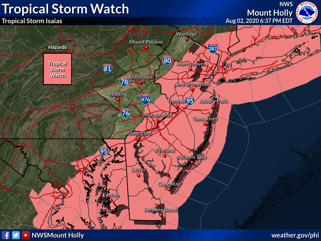
TROPICAL STORM WATCH IN EFFECT...

A Tropical Storm Watch means tropical storm-force winds are possible somewhere within this area within the next 48 hours
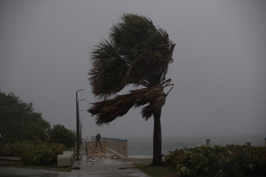
* WIND
    - LATEST LOCAL FORECAST: Equivalent Tropical Storm force wind
        - Peak Wind Forecast: 30-40 mph with gusts to 50 mph
        - Window for Tropical Storm force winds: Tuesday afternoon until Tuesday evening

    - THREAT TO LIFE AND PROPERTY THAT INCLUDES TYPICAL FORECAST UNCERTAINTY IN TRACK, SIZE AND INTENSITY: Potential for wind 39 to 57 mph
        - PLAN: Plan for hazardous wind of equivalent tropical storm force.
        - PREPARE: Efforts to protect property should now be
          underway. Prepare for limited wind damage.
        - ACT: Act now to complete preparations before the wind becomes hazardous.

    - POTENTIAL IMPACTS: Limited
        - Damage to porches, awnings, carports, sheds, and unanchored mobile homes. Unsecured lightweight objects blown about.
        - Many large tree limbs broken off. A few trees snapped or uprooted, but with greater numbers in places where trees are shallow rooted. Some fences and roadway signs blown over.
        - A few roads impassable from debris, particularly within urban or heavily wooded places. Hazardous driving
conditions on bridges and other elevated roadways.
        - Scattered power and communications outages.

* STORM SURGE
    - LATEST LOCAL FORECAST: Localized storm surge possible
        - Peak Storm Surge Inundation: The potential for up to 2 feet above ground somewhere within surge prone areas
        - Window of concern: Tuesday morning until Tuesday evening

    - THREAT TO LIFE AND PROPERTY THAT INCLUDES TYPICAL FORECAST
      UNCERTAINTY IN TRACK, SIZE AND INTENSITY: Potential for storm
      surge flooding greater than 1 foot above ground
        - PLAN: Plan for storm surge flooding greater than 1 foot
          above ground.
        - PREPARE: Efforts should now be underway to prepare for  storm surge flooding, especially in low-lying vulnerable areas.
        - ACT: Take actions to protect life and property. Prepare to leave if evacuation orders are given for your area.

    - POTENTIAL IMPACTS: Limited
        - Localized inundation is possible with storm surge flooding mainly along tidal creeks and rivers and in low-lying spots.
        - Sections of near-river roads and parking lots could become overspread with surge water. Dangerous driving conditions  are possible in places where surge water covers the road.
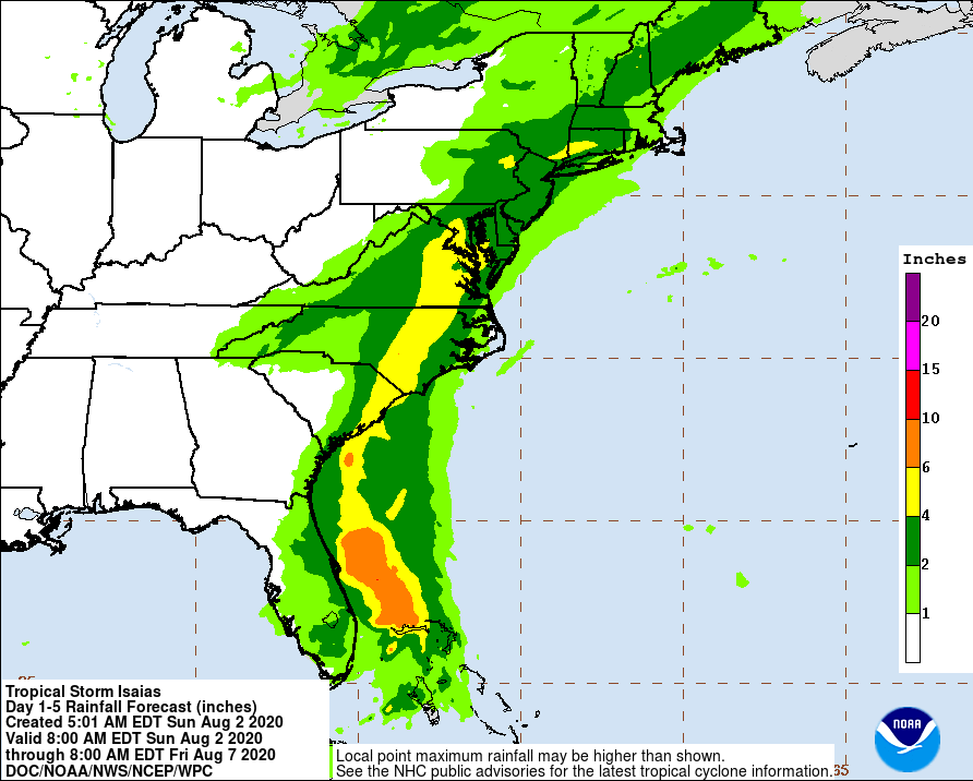
* FLOODING RAIN
    - LATEST LOCAL FORECAST: Flash Flood Watch is in effect
        - Peak Rainfall Amounts: Additional 3-6 inches, with locally higher amounts

    - THREAT TO LIFE AND PROPERTY THAT INCLUDES TYPICAL FORECAST UNCERTAINTY IN TRACK, SIZE AND INTENSITY: Potential for major flooding rain
        - PLAN: Emergency plans should include the potential for  major flooding from heavy rain. Evacuations and rescues are likely.
        - PREPARE: Strongly consider protective actions, especially if you are in an area vulnerable to flooding.
        - ACT: Heed any flood watches and warnings. Failure to take  action will likely result in serious injury or loss of life.

    - POTENTIAL IMPACTS: Extensive
        - Major rainfall flooding may prompt many evacuations and rescues.
        - Rivers and tributaries may rapidly overflow their banks in multiple places. Small streams, creeks, canals, arroyos, and ditches may become dangerous rivers. In mountain areas, destructive runoff may run quickly down valleys while increasing susceptibility to rockslides and mudslides. Flood control systems and barriers may become stressed.
        - Flood waters can enter many structures within multiple communities, some structures becoming uninhabitable or washed away. Many places where flood waters may cover escape routes. Streets and parking lots become rivers of moving water with underpasses submerged. Driving conditions become dangerous. Many road and bridge closures with some weakened or washed out.

* TORNADO
    - LATEST LOCAL FORECAST:
        - Situation is somewhat favorable for tornadoes

    - THREAT TO LIFE AND PROPERTY THAT INCLUDES TYPICAL FORECAST UNCERTAINTY IN TRACK, SIZE AND INTENSITY: Potential for a few tornadoes
        - PLAN: Emergency plans should include the potential for a few tornadoes.
        - PREPARE: If your shelter is particularly vulnerable to tornadoes, prepare to relocate to safe shelter before hazardous weather arrives.
        - ACT: If a tornado warning is issued, be ready to shelter quickly.

    - POTENTIAL IMPACTS: Limited
        - The occurrence of isolated tornadoes can hinder the execution of emergency plans during tropical events.

        - A few places may experience tornado damage, along with power and communications disruptions.

        - Locations could realize roofs peeled off buildings, chimneys toppled, mobile homes pushed off foundations or overturned, large tree tops and branches snapped off, shallow-rooted trees knocked over, moving vehicles blown off roads, and small boats pulled from moorings.

Tropical Storm Isaias Update:

11:00 AM EDT Sun Aug 2
Location: 26.9°N 79.6°W
Moving: NNW at 8 mph
Min pressure: 995 mb
Max sustained: 65 mph

At this hour Isaias have been downgraded to a tropical storm, while the storm was downgraded please note that this is a strong powerful storm. Isaias will bring between 2-5″ of rain (locally higher amounts) to most of the area.
We will see tropical storm force winds as early as late Monday night into Tuesday night. The current track has Isaias moving up the east coast and bringing the storm center right over parts of the area. The NHC “cone” has the center of the storm just off the New Jersey Coast.

Some uncertainty continues regarding the future track, intensity, and timing of this storm which will also affect the ultimate impacts for our region.

Confidence is high that increased swells and rip current risk along the coasts will arrive this weekend and continue through at least Wednesday.

Tropical storm conditions are possible, primarily for coastal locations and the adjacent waters Tuesday into Tuesday night.

Heavy rain leading to flooding is a concern even for areas outside the tropical storm force wind conditions, and is our greatest concern with this storm.


NWS Rainfall forecast

Greater PHila Severe Weather LOGO

Daily Forecast Aug 3, 2020

Have a great Monday. Starting tonight we will see winds pick up and rain move in ahead of Isaias.

Monday
Showers and thunderstorms likely, mainly after 5pm. Partly sunny, with a high near 89.

Monday NightShowers and thunderstorms likely. Some of the storms could produce heavy rain. Low around 73.

Hurricane Isaias Update

The Greater Philadelphia Severe Weather team is tracking Hurricane Isaias from our location in Fairless Hills, Pa. While at this hour the track and intensity of the storms impacts to our area are unknown, confidence is increasing that we will see impacts from the storm.

At this point the main threat for our area is Tropical Storm Force winds (39mph to 73mph) starting Monday night and lasting until Tuesday night. The greatest threat at this time will be along the coast. Heavy rainfall will also become a major concern Monday night through late Tuesday night.

Impacts:

Winds- Strong potential for damaging winds across a large portion of the area, Monday night through Tuesday night.

Flooding Rains– Threat of flooding rains Monday night through Tuesday night across Eastern PA, NJ and Delaware.

Early indications and models are showing possible 2-4″ of rain across most of the area with localized areas up to 6″ of rain across parts of the east coast.

We will bring you the latest updates as the storm gets closer. At this point prepare for the power outages across parts of the area. If you are planning on going down the shore this weekend, we advise you not to go into the water due to swells and rip currents.

Greater PHila Severe Weather LOGO

Weekend Forecast Aug 1 & 2, 2020

Have a great weekend, Our teams will be keeping a close eye on #HurricanIsaias this weekend.

Saturday
A slight chance of showers after 1pm. Partly sunny, with a high near 88.

Saturday Night
A chance of showers and thunderstorms. Mostly cloudy, with a low around 72.

Sunday
A chance of showers and thunderstorms. Mostly cloudy, with a high near 91.

Sunday NightA chance of showers and thunderstorms. Mostly cloudy, with a low around 74. 

Hurricane Isaias Update

HURRICANE WATCH ISSUED FOR PORTIONS OF THE FLORIDA EAST COAST… …SQUALLY WEATHER OVER THE SOUTHEASTERN BAHAMAS AND THE TURKS AND CAICOS ISLANDS SPREADING INTO THE CENTRAL BAHAMAS

Latest Information
11:00 AM EDT Fri Jul 31
Location: 21.7°N 74.5°W
Moving: NW at 16 mph
Min pressure: 992 mb
Max sustained: 75 mph

Our team will be providing updates throughout the weekend. At this time we feel we will see some impacts. We will bring you the latest info as it comes in.

Greater PHila Severe Weather LOGO

Daily Forecast Friday July 31, 2020

Have a great weekend, Our team will bring you the latest on Tropical Storm Isaias this weekend.

Friday
A chance of showers and thunderstorms, mainly before 10am. Partly sunny, with a high near 83.

Friday Night
Mostly cloudy, with a low around 70

Greater PHila Severe Weather LOGO

Daily Forecast July 30, 2020

Have a GREAT Thursday!

Thursday
A slight chance of showers and thunderstorms after 2pm. Mostly sunny, with a high near 94.

Thursday Night
A slight chance of showers and thunderstorms. Mostly cloudy, with a low around 72.

BREAKING: Delaware State Police have issued an Amber Alert for a missing 2-year-old boy.

DELAWARE – Delaware State Police have issued an Amber Alert for a missing 2-year-old boy.

According to police, the preliminary investigation has determined that Christobal Lopez was last seen on Saturday, July 25 at 15 South Front Street in Georgetown, while in the custody of the child’s cousin. 

Police say on Sunday, July 26 the cousin discovered that Cristobal had been taken by his mother 26-year-old Angelina Lopez. Angelina had made arrangements to stay at her cousin’s house for the evening to visit with her child.  Police say Angelina has an active court order indicating that the child is to remain in the custody of the cousin and Angelina is to have no unlawful contact or unsupervised visits with Cristobal.

Cristobal is described as a  2-year old white, Hispanic male child with brown hair and brown eyes. He was last seen wearing blues shoes and a yellow T-shirt.

Angelina is a white Hispanic female, 5-feet-tall, 150 lbs., with brown hair and brown eyes. She was last seen wearing a long sleeve black shirt and blue pants. It was discovered that Angelina took a black and light blue car seat from the cousin’s residence.

Detectives believe the child may be in imminent danger. There is no vehicle information at this time.

Anyone with information regarding their whereabouts should call 911 immediately.