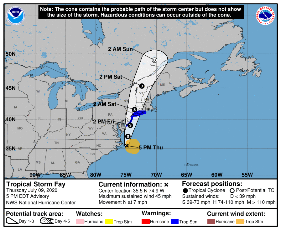
The National Hurricane Center has just named Tropical Storm Fay. This is the earliest six storms have been named in the Atlantic Hurricane Season since 2005. Fay is expected to bring between 2-5″ of rain to parts of the area, flooding, windy conditions as well as chance for tornados. Some models suggest the low comes very close to the area.
CURRENT WEATHER ALERTS:
FLASH FLOOD WATCH IN EFFECT FROM 4AM TO 8PM FRIDAY
A Tropical Storm Warning is in effect fo Cape May New Jersey to Watch Hill Rhode Island including Long Island and Long Island Sound
What Will We See:
Heavy Rain Fall 1-4″ of rain. Some locations could see 4″+
Winds gusting to 45mph along the coast
Isolated Tornados Possible, biggest threat will be Eastern NJ
Biggest threat along i95 will be flash flooding. Please ahead.
TIMING:
Early Morning- Heavy rain moves in from the south
Late Morning/Lunch Time- Heavy Rain moves into most of the area
Late Friday Evening: Heavy Rain from TS Fay moves out.
FAY Current Conditions:
5:00 PM EDT Thu Jul 9
Location: 35.5°N 74.9°W
Moving: N at 7 mph
Min pressure: 1005 mb
Max sustained: 45 mph
RAINFALL:  Fay is expected to produce 3 to 5 inches of rain along and near the track of Fay across the mid-Atlantic states into southeast New York and southern New England. These rains may result in flash flooding where the heaviest amounts occur.

WIND:  Tropical storm conditions are expected to first reach the coast within the warning area on Friday and spread northward  through the warning area Friday night.
A Tropical Storm Warning has been issued from Cape May New Jersey northward to Watch Hill, Rhode Island, including Long Island and Long Island Sound.

SUMMARY OF WATCHES AND WARNINGS IN EFFECT:

A Tropical Storm Warning is in effect for...
* Cape May New Jersey to Watch Hill Rhode Island including Long Island and Long Island Sound

A Tropical Storm Warning means that tropical storm conditions are expected somewhere within the warning area within 36 hours.

For storm information specific to your area, including possible inland watches and warnings, please monitor products issued by your local National Weather Service forecast office.
