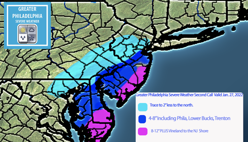
As you know by now a Significant Winter Storm will bring heavy snow to parts of the area. North and West of Philadelphia will see sharp cutoffs. The other main issue will be severe winds that could cause power outages. Use today and the first part of Friday to PREPARE for this storm.
At this point my thinking on this winter storm is close to the i95 area will see 6″+ less the further north you are. Vineland NJ east to the shore will see 8″+ with the jackpot zones being at the NJ shore.
TIMING: Snow arrives after 6pm Friday night. The heaviest will be 2am-11am Saturday morning. The snow will wrap up by dinnertime on Saturday afternoon.
WINDS: Winds could gust as high as 40 MPH along i95 with gust over 60mph possible near the shore.
The latest NWS Watches and Warnings
WINTER STORM WATCH REMAINS IN EFFECT FROM FRIDAY EVENING
THROUGH SATURDAY EVENING...

* WHAT...Heavy snow possible. Total snow accumulations of 4 to
  10 inches possible. Winds could gust as high as 40 mph.

* WHERE...Portions of central, northern and southern New Jersey,
  southeast Pennsylvania, northeast Maryland and central and
  northern Delaware.

* WHEN...From Friday evening through Saturday evening.

* IMPACTS...Travel could be very difficult.

* ADDITIONAL DETAILS...Snow is expected to begin Friday evening in
  Delmarva and southern New Jersey, spreading northward overnight
  into Saturday morning. Snow may be heavy at times through early
  Saturday afternoon before diminishing late in the day. Winds may
  generate areas of blowing snow and low visibilities at times.
  The storm total snow forecast remains a bit uncertain as there
  will likely be a sharp cutoff in the northwest extent of the
  highest snowfall totals, so stay tuned to the latest forecasts.

PRECAUTIONARY/PREPAREDNESS ACTIONS...

Monitor the latest forecasts for updates on this winter storm.

GPSW 2nd Call Map

North and West of the city T-2″
Trenton, Phila, Princeton, Delaware 4-8″+ some areas may see over 6″ in this area
SNJ, Shorepoints 8-12″ + some areas could see more.
At this time I feel the area in darker blue could jump up to a 6-10″ during our next call. We will have a final map out if needed mid day tomorrow.