Mar
20
Daily Forecast Monday March 21, 2022
Have a GREAT Monday!
Monday
Sunny, with a high near 63. West wind 10 to 15 mph.
Monday Night
Partly cloudy, with a low around 43

Have a GREAT Monday!
Monday
Sunny, with a high near 63. West wind 10 to 15 mph.
Monday Night
Partly cloudy, with a low around 43
Strong to Severe Thunderstorms possible this afternoon.
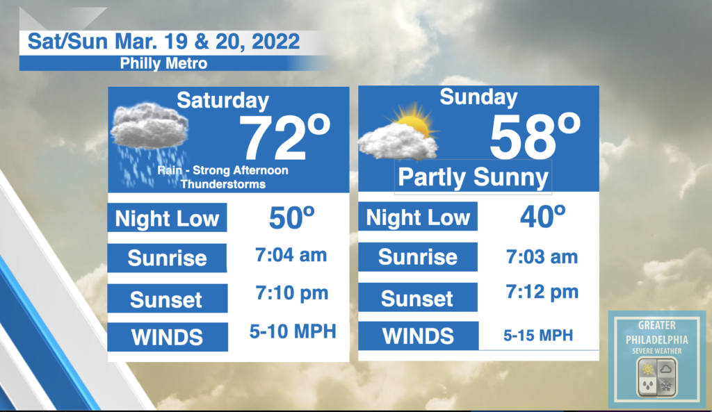
Saturday
Showers likely, with thunderstorms also possible after 2pm. Some of the storms could produce small hail and gusty winds. Patchy fog before 11am. Otherwise, cloudy, with a high near 72. South wind 5 to 10 mph, with gusts as high as 20 mph.
Saturday Night
A chance of showers and thunderstorms before 11pm, then a slight chance of showers between 11pm and 2am. Partly cloudy, with a low around 50. West wind 5 to 10 mph, with gusts as high as 20 mph.
Sunday
Partly sunny, with a high near 58. West wind 10 to 15 mph, with gusts as high as 25 mph.
Sunday Night
Mostly clear, with a low around 40.
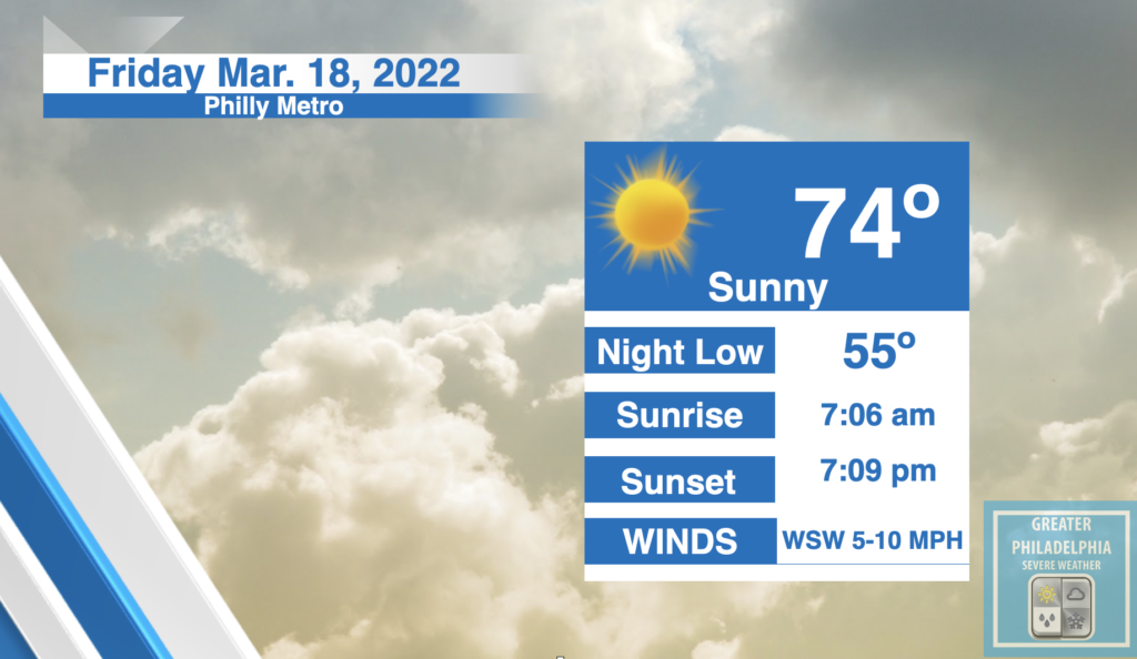
Except for a few afternoon clouds, mainly sunny. High 74F. Winds WSW at 5 to 10 mph.
Considerable cloudiness. Occasional rain showers later at night. Low near 55F. Winds SSE at 5 to 10 mph. Chance of rain 60%
Have a great day!
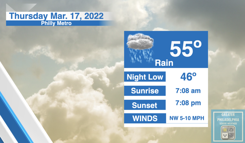
Thursday
Rain, mainly after 9am. Patchy fog before 8am. High near 55. Northeast wind 5 to 10 mph.
Thursday Night
Rain likely, mainly before 8pm. Cloudy, then gradually becoming partly cloudy, with a low around 46.
Have a great day!
Wednesday
Sunny, with a high near 70. Calm wind becoming south around 5 mph in the afternoon.
Wednesday Night
A chance of showers after 2am. Increasing clouds, with a low around 45. Southeast wind around 5 mph becoming calm in the evening.
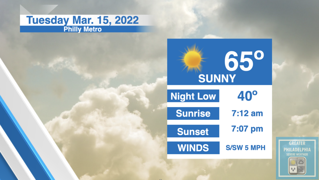
Tuesday
Mostly sunny, with a high near 64. Calm wind becoming southwest around 5 mph in the afternoon.
Tuesday Night
Partly cloudy, with a low around 40
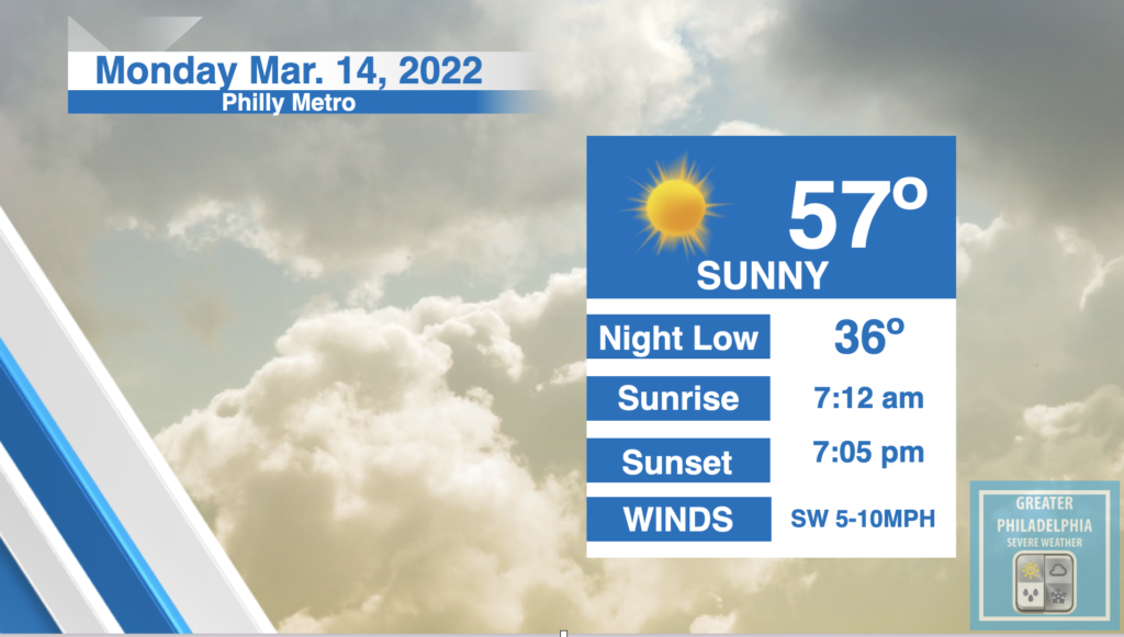
Monday
Sunny, with a high near 57. Southwest wind 5 to 10 mph.
Monday Night
Partly cloudy, with a low around 36. Southwest wind around 5 mph.


WIND ADVISORY REMAINS IN EFFECT UNTIL 1 AM EST SUNDAY...

* WHAT...Northwest winds 15 to 25 mph with gusts up to 50 mph
  expected.

* WHERE...Portions New Jersey, southeast Pennsylvania, the eastern
  shores of Maryland, and Delaware.

* WHEN...Until 1 AM EST Sunday.

* IMPACTS...Gusty winds could blow around unsecured objects.
  Tree limbs could be blown down and a few power outages may
  result.

* ADDITIONAL DETAILS...Strong winds develop late this morning
  morning and continue into the afternoon. There may be a lull
  this evening before winds increase once again.

PRECAUTIONARY/PREPAREDNESS ACTIONS...

Use extra caution when driving, especially if operating a high
profile vehicle. Secure outdoor objects.

Please post current observations as you see them. This is a fast moving system that will bring 1-2″/hr snowfall rates. This afternoon we will see temps dropping fast. Use caution if driving after the snow stops as most surfaces will freeze.

Saturday
Rain before 2pm, then rain and snow changing to all snow after 3pm. Temperature falling to around 31 by 5pm. Breezy, with a northwest wind 10 to 15 mph increasing to 20 to 25 mph in the afternoon.
Saturday Night
A slight chance of snow before 10pm. Mostly cloudy, then gradually becoming mostly clear, with a low around 19. Blustery, with a west wind 20 to 25 mph. Chance of precipitation is 20%.
Sunday
Sunny, with a high near 36. West wind 10 to 15 mph, with gusts as high as 25 mph.
Sunday Night
Mostly clear, with a low around 29.