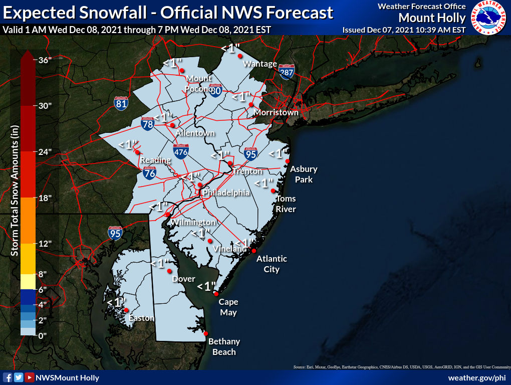
Warm Saturday To Bring Storms and Wind Advisory

While we will be close to hitting 70s on Saturday, the area will see wind gust up to 45mph through the late evening. This has prompted the NWS to issue a Wind Advisory from 1pm Saturday until 1am Sunday. A line of showers will move across the area durning the evening that will bring the potential for damaging winds and a tornado can’t be ruled out.


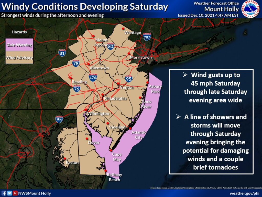
WIND ADVISORY IN EFFECT FROM 1 PM SATURDAY TO 1 AM EST
SUNDAY

* WHAT...South winds 15 to 25 mph with gusts up to 45 mph
  expected. Winds will abruptly shift northwest behind a cold
  front Saturday evening.

* WHERE...Portions of central, northern and southern New Jersey
  and east central and southeast Pennsylvania.

* WHEN...From 1 PM Saturday to 1 AM EST Sunday.

* IMPACTS...Gusty winds could blow around unsecured objects.
  Tree limbs could be blown down and a few power outages may
  result.

* ADDITIONAL DETAILS...Secure any outdoor holiday decorations from
  blowing away in the wind.

PRECAUTIONARY/PREPAREDNESS ACTIONS...

Use extra caution when driving, especially if operating a high
profile vehicle. Secure outdoor objects.

Wednesday Snow, Record Temps and White Christmas???

As everyone has been waiting for the final calls on our mid week sNOw storm. Our final call is a Dusting to half inch for everyone. The storm is trending further south which result in not much snow. Just be alert for wet and slippery conditions.


A big warming trend sets up for the next couple of weeks which will result in our area seeing above normal temps. This coming weekend an airmass will overspread the area on Saturday. We will see record high temps some locations may see temps into the 70s!!!!


Now we are 18 days until Christmas at this point I do not see any major signs for a White Christmas so at this point I think it is safe to say it will NOT be a White Christmas.

Daily Forecast Wednesday December 8, 2021

Let It Snow Let’s It Snow Let It Snow…..

Wednesday
A chance of snow later this morning until around dinner time. Cloudy, with a high near 39. New snow accumulation of less than a half inch possible.

Wednesday Night
Cloudy during the early evening, then gradual clearing, with a low around 26

Mid Week Winter Storm To Bring Light Snow To The Area

DEC. 7th UPDATE:

At this time our final call is a C-1″ for most of the area. Most of the snow will melt on contact but grassy surfaces could see a coating. NO accumulations with this one.


The first winter storm of the year is less than 48 hours away. While this will not bring significant snowfall to the area, the first snowfall always poses challenges with roads and driving. Most of the area will see a COATING to 2″ (most areas will be closer to a coating to 0.5″


Again most of the area will see a coating to 2″ of snow. Most of the snow will move into the area late morning on Wednesday into the early afternoon before moving out of the area by the evening rush. While most accumulations will be on grassy surfaces a slush mess on the roads is possible. While there is a lot of time between now and the storm if we need to adjust any information tomorrow we will.

WINTER DRIVING TIPS FROM PENNDOT!
Remember, if winter weather is forecast, eliminate all unnecessary travel. This will keep you and your family safe and allow PennDOT to more easily perform its winter duties. However, if you must travel, PennDOT offers the following tips for safe driving this winter season

High Winds This Afternoon

As you can feel we have a GREAT Weather day but it won’t last long. While temps are in the 60s across most of the area. We will see a cold front move across the area late afternoon. When this front moves across the area wind gust 40-50 mph are possible. By late tonight temps will be in the upper 30s/low 40s.

As of this time the Wednesday systems looks to bring light snow to most of the area C-2” is very possible but a more official forecast will come later.

Until then enjoy this great weather.

Daily Forecast Tuesday December 7, 2021

Have a GREAT Day! We will have final updates on the winter storm that will bring light snow to the area tomorrow this afternoon. Have a great Tuesday!

Tuesday
Mostly sunny, with a high near 42. West wind 5 to 10 mph.

Tuesday Night
Mostly cloudy, with a low around 29

Daily Forecast December 6, 2021

Have a great Monday we will have updates on the track for our potential winter storm later today.

Monday
Showers likely, mainly after 3pm. Cloudy, with a high near 63. South wind 5 to 10 mph increasing to 10 to 15 mph in the afternoon. Winds could gust as high as 30 mph.

Monday Night
A chance of showers, mainly before 10pm. Cloudy during the early evening, then gradual clearing, with a low around 32. West wind 10 to 15 mph, with gusts as high as 30 mph

Mid Week Storm Update

The low pressure system that will pass by on Wednesday could bring a few inches of snow to parts of the area highest chance right now is to our south. While at this time things are still very uncertain on how much precip will fall. Take everything with a grain of salt.

The latest model trends have began to keep the low to our southeast which would favor any precipitation to be mostly snow, tho along the coast it could be a rain/snow mix. BUT if this continues to trend to the southeast then most of the precip will be over the ocean and not much over land. The third option is that it moves further northwest resulting in a rain/snow mix for most of us. As you will see below we have two snapshots of two models around the same time, two completely different forecast.

At this point it appears most of this will fall during the day on Wednesday. The big concern would be the wet driving conditions on Wednesday morning. While it is unclear how much snow will fall but if I had to guess right now a general 1-2″ is possible. We will be following the trends overnight and have more on this post updated as models run.

18z Models

The 18z Nam at 69hrs shows snow over most of the area.
The 18z GFS at 72 hrs shows light snow/mix over parts of the area. But we can see the main system to the south.