Dec
09
Daily Forecast December 9, 2025
Have a great Tuesday
Tuesday
Increasing clouds, with a high near 33. Calm wind becoming south around 5 mph in the afternoon.
Tuesday Night
Mostly cloudy, with a low around 27
Have a great Tuesday
Tuesday
Increasing clouds, with a high near 33. Calm wind becoming south around 5 mph in the afternoon.
Tuesday Night
Mostly cloudy, with a low around 27
Have a great Monday!
Monday
Partly sunny, with a high near 31. Northeast wind 10 to 15 mph, with gusts as high as 25 mph.
Monday Night
Mostly cloudy, then gradually becoming mostly clear, with a low around 14
Have a great weekend!
Saturday
Mostly cloudy, with a high near 42. Calm wind becoming west around 5 mph in the afternoon.
Saturday Night
Partly cloudy, with a low around 25. Calm wind becoming west around 5 mph.
Sunday
Partly sunny, with a high near 42. Calm wind becoming northwest around 5 mph.
Sunday Night
Mostly cloudy, with a low around 25
Have a great Friday! We could see some snow showers this afternoon. No accumulation expected.
Friday
Mostly cloudy, with a high near 32. Calm wind.
Friday Night
A slight chance of snow. Mostly cloudy, with a low around 25. Calm wind. Chance of precipitation is 20%.
Have a great Wednesday! We could see some snow on Friday.
Wednesday
Sunny, with a high near 40. Northwest wind around 5 mph.
Wednesday Night
Mostly clear, with a low around 27
We will see rain, sleet and snow. Rain/MIx closer to i95 and more snow towards the north.
Tuesday
A chance of snow and sleet then changing to rain. High near 40.
Tuesday Night
Cloudy during the early evening, then gradual clearing, with a low around 26
Winter Weather Advisory is up for north and west suburbs.

Happy Dec 1
Tomorrow we will see a system bring rain and snow to the area not much accumulation around on 95 the further north, you go the more snow you’ll see.
Monday
Sunny, with a high near 42. Northwest wind 5 to 10 mph, with gusts as high as 20 mph.
Monday Night
Snow likely after 1am. Increasing clouds, with a low around 27.
Have a good weekend
Saturday
Sunny, with a high near 42. West wind 5 to 10 mph.
Saturday Night
Mostly cloudy, with a low around 28. Calm wind.
Sunday
A chance of rain and snow before 10am, then rain. High near 47. Light southeast wind becoming south 5 to 10 mph in the morning. Chance of precipitation is 80%. Little or no snow accumulation expected.
Sunday Night
A chance of rain before 1am. Mostly cloudy, with a low around 31
We are keeping an eye on a system that could bring rain and snow to parts of the area on Tuesday. We’ll continue to monitor model runs and update as the signal becomes clearer.
Have a great Friday!
Friday
Increasing clouds, with a high near 42. Breezy, with a west wind 15 to 20 mph, with gusts as high as 40 mph.
Friday Night
Mostly clear, with a low around 27
Thanksgiving Day
Mostly cloudy, with a high near 43. West wind around 15 mph, with gusts as high as 35 mph.
Thursday Night
Mostly clear, with a low around 29.
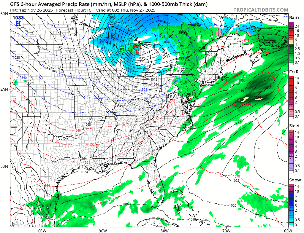
There are early indications from several long-range weather models that the Philadelphia region could see its first chance of snow next week. Guidance from the GFS, ECMWF, and Canadian models is beginning to converge on a trough digging into the Northeast. Confidence is still low at this range, but the overall pattern is trending more favorable for wintry weather. We’ll continue to monitor model runs and update as the signal becomes clearer.