Patchy fog between 10am and 11am. Patchy freezing fog before 10am. Otherwise, partly sunny, with a high near 45. Calm wind becoming southeast around 5 mph in the afternoon.
Thursday Night
Rain, with thunderstorms also possible after 4am. Temperature rising to around 55 by 5am. Breezy, with a south wind 10 to 15 mph increasing to 15 to 20 mph after midnight. Winds could gust as high as 40 mph
WINTER STORM WARNING IN EFFECT FROM 7 PM THIS EVENING TO 1 PM EST SUNDAY...
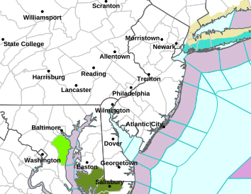
* WHAT...Heavy snow expected. Total snow accumulations between 3 and 5 inches.
* WHERE...Portions of southern New Jersey and southeast Pennsylvania.
* WHEN...From 7 PM this evening to 1 PM EST Sunday.
* IMPACTS...Roads, and especially bridges and overpasses, will likely become slick and hazardous. Plan on slippery road conditions.
PRECAUTIONARY/PREPAREDNESS ACTIONS...
If you must travel, keep an extra flashlight, food, and water in your vehicle in case of an emergency. The latest road conditions for the state you are calling from can be obtained by calling 5 1 1.
The Winter Weather Advisory is still in effect for everyone else
WINTER WEATHER ADVISORY REMAINS IN EFFECT FROM 7 PM THIS EVENING
TO 1 PM EST SUNDAY...

* WHAT...Snow expected. Total snow accumulations between 2 and 4
  inches.

* WHERE...Portions of northern Delaware and central, northern, and
  southern New Jersey.

* WHEN...From 7 PM this evening to 1 PM EST Sunday.

* IMPACTS...Plan on slippery road conditions.

PRECAUTIONARY/PREPAREDNESS ACTIONS...

Slow down and use caution while traveling. The latest road
conditions for the state you are calling from can be obtained by
calling 5 1 1.

Be prepared for slippery roads. Slow down and use caution while
driving. If you are going outside, watch your first few steps taken
on stairs, sidewalks, and driveways. These surfaces could be icy and
slippery, increasing your risk of a fall and injury.
A fast moving system will bring 2-4" of snow to the area late Saturday night into Sunday morning. My first call is going to be a general 2-4" of snow across most of the area. Full report will be posted this evening.


* WHAT...Snow expected. Total snow accumulations between 2 and 4
  inches.

* WHERE...Portions of central and northern Delaware, northeast
  Maryland, central, northern, northwest, and southern New Jersey,
  and southeast Pennsylvania.

* WHEN...From 7 PM Saturday to 1 PM EST Sunday.

* IMPACTS...Plan on slippery road conditions.

PRECAUTIONARY/PREPAREDNESS ACTIONS...

Slow down and use caution while traveling. The latest road
conditions for the state you are calling from can be obtained by
calling 5 1 1.

Be prepared for slippery roads. Slow down and use caution while
driving. If you are going outside, watch your first few steps taken
on stairs, sidewalks, and driveways. These surfaces could be icy and
slippery, increasing your risk of a fall and injury.