Dec
20
Daily Forecast Tuesday Dec. 21, 2021
Have a great Tuesday!
Tuesday
Partly sunny, with a high near 44.
Tuesday Night
Mostly cloudy, with a low around 32.

Have a great Tuesday!
Tuesday
Partly sunny, with a high near 44.
Tuesday Night
Mostly cloudy, with a low around 32.
Have a great Monday! This will be one long week for a lot of people. Just remember the end of this year is near!
Monday
Sunny, with a high near 39. North wind around 5 mph becoming calm.
Monday Night
Mostly clear, with a low around 26
Have a great weekend!
Saturday
Rain likely before 1pm, then a chance of rain after 3pm. Cloudy, with a high near 49. East wind around 5 mph. Chance of precipitation is 70%. New precipitation amounts of less than a tenth of an inch possible.
Saturday Night
Rain, mainly before 1am. Low around 38. Northeast wind 5 to 10 mph becoming northwest after midnight. Chance of precipitation is 80%. New precipitation amounts of less than a tenth of an inch possible.
Sunday
A slight chance of rain before 10am. Mostly cloudy, then gradually becoming sunny, with a high near 43. Northwest wind around 15 mph. Chance of precipitation is 20%.
Sunday Night
Mostly clear, with a low around 24. North wind 5 to 10 mph.
Happy National Ugly Sweater DAY!
Let’s See That ugly sweater!
Friday
Mostly sunny, with a high near 59. West wind 5 to 10 mph.
Friday Night
Rain, mainly after 2am. Low around 40. West wind around 5 mph
Have a great Thursday!
Thursday
Partly sunny, with a high near 63. Southwest wind around 10 mph, with gusts as high as 20 mph.
Thursday Night
A slight chance of showers between 10pm and 1am. Mostly cloudy, with a low around 49.
Have a great day!
Wednesday
Increasing clouds, with a high near 55. Northeast wind around 5 mph becoming southeast in the afternoon.
Wednesday Night
Cloudy, with a low around 48
Have a great Tuesday!
Tuesday
Sunny, with a high near 53. Light and variable wind becoming north 5 to 10 mph in the morning.
Tuesday Night
Mostly clear, with a low around 34.
Have a GREAT Monday! We have a great weather week ahead. Looks like s few showers Friday night but otherwise a clear week.
Monday
Sunny, with a high near 53
Monday Night
Mostly clear, with a low around 35

Have a great weekend. Wind Advisory in effect from 1pm Saturday until 1am Sunday.
Saturday
A chance of showers, mainly before 2pm. Patchy fog before 10am. Otherwise, cloudy, with a high near 71. Breezy, with a southwest wind 10 to 15 mph increasing to 15 to 20 mph in the afternoon. Winds could gust as high as 45 mph.
Saturday Night
Showers and thunderstorms before 1am, then a slight chance of showers between 1am and 4am. Low around 40. Breezy, with a southwest wind 15 to 25 mph becoming west after midnight. Winds could gust as high as 50 mph.
Sunday
Mostly cloudy through mid morning, then gradual clearing, with a high near 48. Northwest wind around 15 mph, with gusts as high as 35 mph.
Sunday Night
Mostly clear, with a low around 31.

While we will be close to hitting 70s on Saturday, the area will see wind gust up to 45mph through the late evening. This has prompted the NWS to issue a Wind Advisory from 1pm Saturday until 1am Sunday. A line of showers will move across the area durning the evening that will bring the potential for damaging winds and a tornado can’t be ruled out.
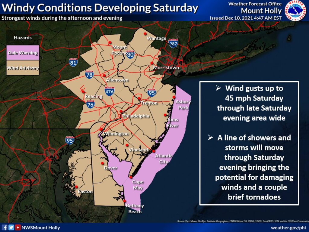
WIND ADVISORY IN EFFECT FROM 1 PM SATURDAY TO 1 AM EST
SUNDAY

* WHAT...South winds 15 to 25 mph with gusts up to 45 mph
  expected. Winds will abruptly shift northwest behind a cold
  front Saturday evening.

* WHERE...Portions of central, northern and southern New Jersey
  and east central and southeast Pennsylvania.

* WHEN...From 1 PM Saturday to 1 AM EST Sunday.

* IMPACTS...Gusty winds could blow around unsecured objects.
  Tree limbs could be blown down and a few power outages may
  result.

* ADDITIONAL DETAILS...Secure any outdoor holiday decorations from
  blowing away in the wind.

PRECAUTIONARY/PREPAREDNESS ACTIONS...

Use extra caution when driving, especially if operating a high
profile vehicle. Secure outdoor objects.