While the storm moves out this morning, do what you can to clear and salt driveways, sidewalks etc. Tonight lows will get into the upper teens and anything leftover on surfaces will freeze.
Thursday
Snow tapering off this morning. Partly sunny, with a high near 34. Breezy, with a north wind 15 to 20 mph decreasing to 5 to 10 mph in the afternoon. Winds could gust as high as 30 mph.
Thursday Night
Mostly cloudy, with a low around 19
Middlesex-Mercer-Delaware-Philadelphia-Eastern Chester-
Eastern Montgomery-Lower Bucks-
Including the cities of New Brunswick, Trenton, Media,
Philadelphia, West Chester, Kennett Square, Norristown, Lansdale,
Morrisville, and Doylestown
318 AM EST Wed Dec 16 2020

* WHAT...Heavy snow mixed with sleet expected. Total snow and
  sleet accumulations of 6 to 12 inches. Winds gusting as high as
  40 mph.

* WHERE...Portions of central and northern New Jersey and
  southeast Pennsylvania.

* WHEN...From noon today to 10 AM EST Thursday.

* IMPACTS...Travel could be very difficult to impossible. The
  hazardous conditions will impact the evening commute tonight and
  the morning commute on Thursday. Heavy snow and gusty winds
  could result in power outages.

* ADDITIONAL DETAILS...Snow will move in from southwest to
  northeast this afternoon and early evening, and will be heavy at
  times this evening. The snow will likely mix with and change to
  sleet this evening, before ending as a period of snow on
  Thursday morning.

PRECAUTIONARY/PREPAREDNESS ACTIONS...

If you must travel, keep an extra flashlight, food, and water in
your vehicle in case of an emergency.

The latest road conditions for the state you are calling from can
be obtained by calling 5 1 1.
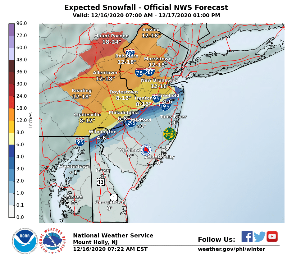
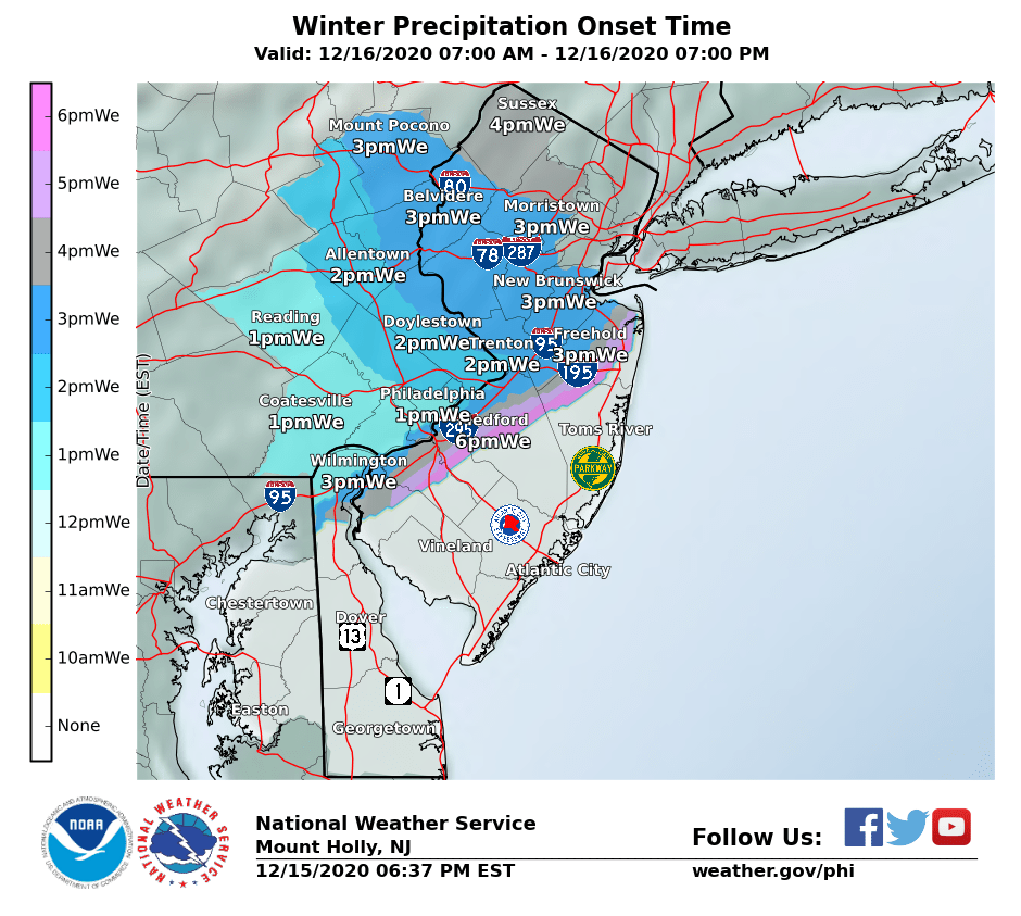
Wednesday’s winter storm will start to move into the area in early afternoon. Into Philadelphia by 1pm, Trenton by 2pm and Shore Points by 3pm
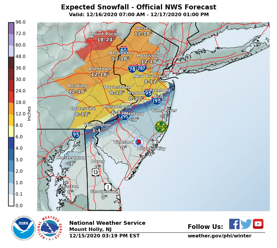
Snow amounts will be significant near and north and west of the I-95 corridor. Snowfall rates could reach 1 to 2 inches per hour for a time late day Wednesday into Wednesday night, causing significantly reduced visibility and potentially crippling travel impacts in places. One of the big impacts are that we could see winds 15-30mph with gust over 40mph at times, these winds will increase the chances for power outages in the area. If you will be traveling tomorrow afternoon/evening prepare for major travel delays due to this being the first snowfall and major snowfall of the season in some areas. Make sure you have a full tank of gas, phones charges, shovel and blankets in your vehicle.
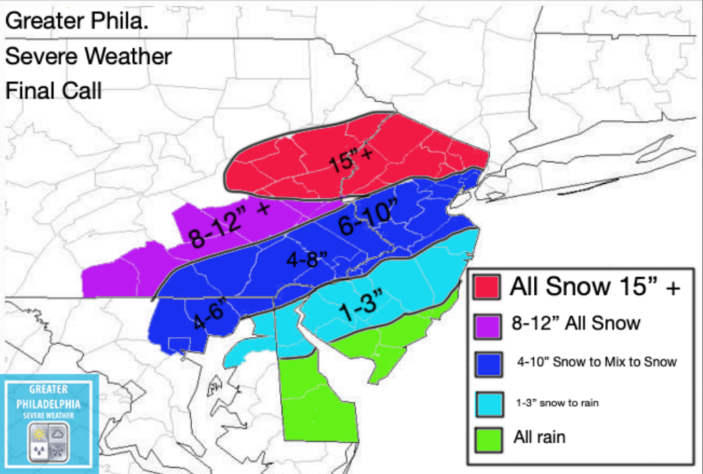
As you can see below is our final call map for the upcoming Winter Storm.
Green- Shore points and those along the coast might see a few snowflakes mixing in but mainly rain.
Light Blue- Mix/Rain for majority of the storm
Dark Blue- Snow to Mix then back to snow. These areas will see very sharp cutoffs within the same county at times. Also the wildcard area, if the storm moves southeast as we started to see with the 18z nam. This could be all snow and areas could see over 12″ but at this point we do not feel that is going to happen. Higher amounts on map are for higher locations within that area. Locally higher amounts possible.
Purple/Blue- All SNOW
NOTE: A shift by 10-20 miles either north or south will impact totals.
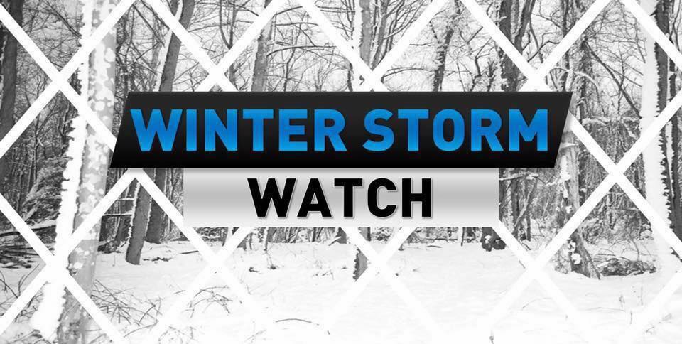
A Winter Storm Watch will go into effect at 10am until 10am Thursday. Snow will begin to move into the area this afternoon. Tonights afternoon rush hour will be a mess.
Wednesday A chance of snow and sleet. High near 34. Northeast wind 5 to 15 mph. New snow accumulation of 2 to 4 inches possible.
Wednesday Night Snow. The snow could be heavy at times. Low around 26. Blustery, with a northeast wind 15 to 20 mph, with gusts as high as 35 mph. . Additional snow and sleet accumulation of 7 to 11 inches possible.
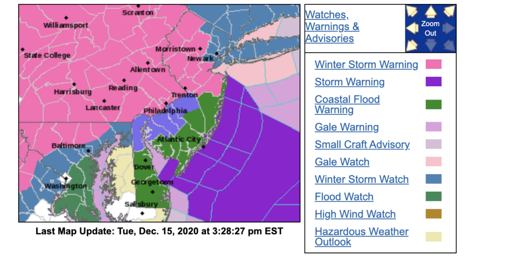
WINTER STORM WARNING NOW IN EFFECT FROM NOON WEDNESDAY TO
10 AM EST THURSDAY...

* WHAT...Heavy mixed precipitation expected. Total snow and sleet
  accumulations of 6 to 12 inches. Winds gusting as high as 35
  mph.

* WHERE...Portions of central, northern and northwest New Jersey
  and southeast Pennsylvania.

* WHEN...From noon Wednesday to 10 AM EST Thursday.

* IMPACTS...Travel could be very difficult to impossible. The
  hazardous conditions could impact the evening commute on
  Wednesday and the morning commute on Thursday. The heavy snow
  could result in power outages.

* ADDITIONAL DETAILS...Snow will move in from southwest to
  northeast Wednesday afternoon and early evening. The snow could
  become heavy at times Wednesday evening. The snow will likely
  mix with and change to sleet late Wednesday evening and
  Wednesday night, before ending as a period of snow on Thursday
  morning.

PRECAUTIONARY/PREPAREDNESS ACTIONS...

If you must travel, keep an extra flashlight, food, and water in
your vehicle in case of an emergency.

The latest road conditions for the state you are calling from can
be obtained by calling 5 1 1.
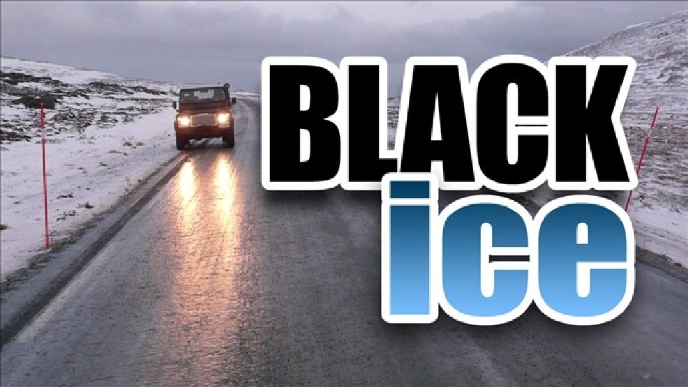
Temperatures falling near or below freezing combined with moisture
near the ground may result in patchy black ice developing. The
greatest risk is in sheltered areas and valleys and on elevated
surfaces. The risk should diminish later tonight as winds
increase and drier moves into the region.

Motorists should drive with extra caution this evening.  This is
especially true if roads look wet, as they actually may be icy
instead.
A Winter Storm WATCH is in effect starting at 10am Wed.
Incase you didn’t know, its going to snow this week. This is something we have been talking about for the past few days, expect major to significant impact from the Nor’easter on Wednesday. At this point we are confident this storm will begin around midday/early afternoon on Wednesday and continue until early Thursday AM.
Areas near i95 will see some sleeting and mixing. We are sorry to say, but the shore points it’s mostly rain for you. The rest of the area will see significant snowfall (some areas could peak over 16” plus of snowfall). We expect the NWS to upgrade the current Winter Storm Watch to a Warning. Once that happens we will pass that information along. I will be issuing our final call map tomorrow afternoon if needed.
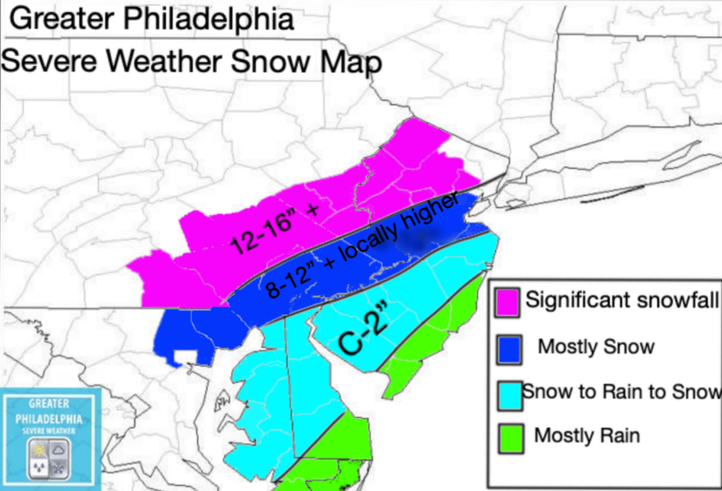
Our map below you will see it has a lot of different totals on it for the areas.
Purple – 12-16”+ Dark Blue Mostly 8-12+” (some areas could see higher amounts. Closer to i95 could see lower due to mixing issues) Light Blue – C-2” Green -All Rain
* WHAT...Heavy snow possible. Total snow accumulations of 5 or
  more inches possible. Winds could gust as high as 30 mph.

* WHERE...Portions of New Jersey, southeast Pennsylvania and
  northern Delaware along and near the I-95 corridor.

* WHEN...From Wednesday morning through Thursday morning.

* IMPACTS...Travel could be very difficult. The hazardous
  conditions could impact the morning or evening commute.

* ADDITIONAL DETAILS...Snow is anticipated to move into the region
  Wednesday morning and some areas in the watch may mix with sleet
  and rain. We anticipate there will likely be a sharp gradient in
  snow totals depending on precipitation type.

Here is our FIRST CALL and SNOW MAPS for this system:
https://greaterphilaseverewx.com/mid-week-winter-storm-update-w-first-call-map/