Aug
08
Daily Forecast Thursday Aug. 8, 2024
Thursday
Showers likely and possibly a thunderstorm. Cloudy, with a high near 76.
Thursday Night
Showers and possibly a thunderstorm. Low around 73..

Thursday
Showers likely and possibly a thunderstorm. Cloudy, with a high near 76.
Thursday Night
Showers and possibly a thunderstorm. Low around 73..
Flood watch in effect until later today.
Wednesday
Showers likely and possibly a thunderstorm. Some of the storms could produce heavy rainfall. Cloudy, with a high near 77.
Wednesday Night
A chance of showers and thunderstorms. Cloudy, with a low around 66.
Have a great Tuesday! Severe weather this afternoon
Tuesday
Showers and thunderstorms likely, after 2pm. Partly sunny, with a high near 90.
Tuesday Night
Showers likely and possibly a thunderstorm. Some of the storms could produce heavy rainfall. Low around 69.

* WHAT...Flooding caused by excessive rainfall is possible.

* WHERE...Portions of northern Delaware, including the following
  area, New Castle, New Jersey, including the following areas,
  Camden, Coastal Ocean, Eastern Monmouth, Gloucester, Hunterdon,
  Mercer, Middlesex, Northwestern Burlington, Ocean, Salem,
  Somerset, Southeastern Burlington and Western Monmouth, and
  southeast Pennsylvania, including the following areas, Delaware,
  Eastern Chester, Eastern Montgomery, Lower Bucks, Philadelphia,
  Upper Bucks, Western Chester and Western Montgomery.

* WHEN...From Tuesday afternoon through Wednesday morning.

* IMPACTS...Excessive runoff may result in flooding of rivers,
  creeks, streams, and other low-lying and flood-prone locations.
  Flooding may occur in poor drainage and urban areas.

* ADDITIONAL DETAILS...
  - A cold front will approach from the north and west on Tuesday
    and will cross the region Tuesday night. This front will
    interact with tropical moisture associated with Hurricane
    Debby to result in heavy downpours over the area. Rainfall
    totals will average 1 to 2 inches, but locally higher amounts
    are possible.

We are keeping close eye on Tropical System Debbie.
Monday
Patchy fog before 8am. Otherwise, sunny, with a high near 94. Light west wind increasing to 5 to 10 mph in the afternoon.
Monday Night
Partly cloudy, with a low around 74

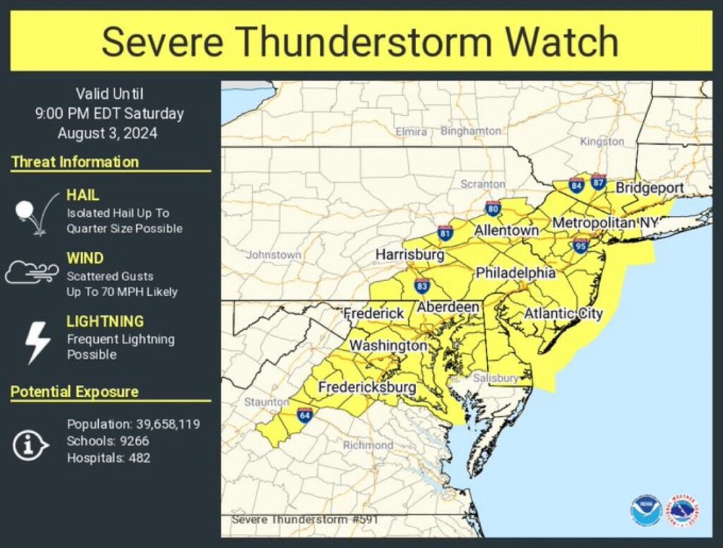
A severe thunder storm watch and flood watch have been issued until 9pm. The heat advisory is still in effect until 8pm
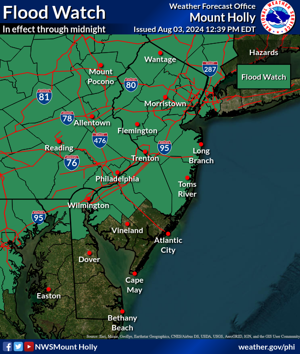
FLOOD WATCH IN EFFECT UNTIL MIDNIGHT EDT TONIGHT...

* WHAT...Flash flooding caused by excessive rainfall is possible.

* WHERE...Portions of northern Delaware, including the following
  area, New Castle, New Jersey, including the following areas,
  Camden, Coastal Ocean, Eastern Monmouth, Gloucester, Hunterdon,
  Mercer, Middlesex, Morris, Northwestern Burlington, Ocean, Salem,
  Somerset, Southeastern Burlington, Sussex, Warren and Western
  Monmouth, and Pennsylvania, including the following areas, Berks,
  Carbon, Delaware, Eastern Chester, Eastern Montgomery, Lehigh,
  Lower Bucks, Monroe, Northampton, Philadelphia, Upper Bucks,
  Western Chester and Western Montgomery.

* WHEN...Until midnight EDT tonight.

* IMPACTS...Excessive runoff may result in flooding of rivers,
  creeks, streams, and other low-lying and flood-prone locations.

* ADDITIONAL DETAILS...
  - Storms this afternoon will be capable of heavy rain. Some
    locations could get multiple rounds of storms, increasing the
    potential for flash flooding, especially in urban areas and
    other areas with poor drainage. Although storms may linger
    past midnight, overnight storms aren`t expected to have as
    much potential for heavy rainfall.
  - http://www.weather.gov/safety/flood

PRECAUTIONARY/PREPAREDNESS ACTIONS...

You should monitor later forecasts and be prepared to take action
should Flash Flood Warnings be issued.
Enjoy the weekend!
Saturday
Showers and thunderstorms likely, mainly after 5pm. Patchy fog before 8am. Otherwise, mostly sunny, with a high near 90.
Saturday night
Showers and thunderstorms, mainly before 9pm. Some of the storms could produce heavy rainfall. Patchy fog after 2am. Low around 74.
Sunday
A chance of showers and thunderstorms, Some of the storms could produce heavy rainfall. Patchy fog before 8am. Otherwise, mostly cloudy, with a high near 87.
Sunday Night
Showers likely before 8pm. The rain could be heavy at times. Patchy fog. Otherwise, cloudy during the early evening, then gradual clearing, with a low around 71

..HEAT ADVISORY IN EFFECT FROM 11 AM THIS MORNING TO 8 PM EDT THIS
EVENING...

* WHAT...Heat index values up to 101 expected.

* WHERE...In Delaware, New Castle County. In New Jersey, Mercer,
  Camden, Gloucester, and Northwestern Burlington Counties. In
  Pennsylvania, Delaware, Eastern Chester, Eastern Montgomery, Lower
  Bucks, and Philadelphia Counties.

* WHEN...From 11 AM this morning to 8 PM EDT this evening.

* IMPACTS...Hot temperatures and high humidity may cause heat
  illnesses.

PRECAUTIONARY/PREPAREDNESS ACTIONS...

Drink plenty of fluids, stay in an air-conditioned room, stay out of
the sun, and check up on relatives and neighbors.
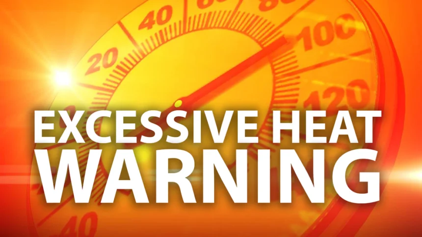
EXCESSIVE HEAT WARNING IN EFFECT FROM 11 AM TO 8 PM EDT WEDNESDAY...

* WHAT...Dangerously hot conditions with heat index values up to 105 expected.

* WHERE...In New Jersey, Mercer, Camden, Gloucester, and Northwestern Burlington Counties. In Pennsylvania, Delaware, Eastern Montgomery, Lower Bucks, and Philadelphia Counties.

* WHEN...From 11 AM to 8 PM EDT Wednesday.

* IMPACTS...Heat related illnesses increase significantly during extreme heat and high humidity events.

PRECAUTIONARY/PREPAREDNESS ACTIONS...

Drink plenty of fluids, stay in an air-conditioned room, stay out of the sun, and check up on relatives and neighbors.

Do not leave young children and pets in unattended vehicles. Car interiors will reach lethal temperatures in a matter of minutes.

To reduce risk during outdoor work, the Occupational Safety and Health Administration recommends scheduling frequent rest breaks in shaded or air conditioned environments. Anyone overcome by heat should be moved to a cool and shaded location. Heat stroke is an emergency! Call 9 1 1.
A Heat Advisory is in effect until this Evening.
Friday
A chance of showers and thunderstorms, mainly after 2pm. Partly sunny, with a high near 95. Heat index values as high as 101
Friday Night
Showers and thunderstorms likely before 5am, then isolated showers. Mostly cloudy, with a low around 74.