Hurricane Statement from NWS

The NWS in Mt Holly has issued this Hurricane Local Statement:

**Tropical Storm Fay to Approach the New Jersey Coast**
This product covers NEW JERSEY...DELAWARE...SOUTHEASTERN PENNSYLVANIA AND NORTHEAST MARYLAND

NEW INFORMATION
---------------

* CHANGES TO WATCHES AND WARNINGS:
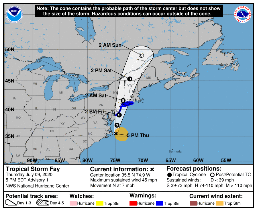
    - A Tropical Storm Warning has been issued for Atlantic, Atlantic Coastal Cape May, Cape May, Coastal Atlantic, Coastal Ocean, Eastern Monmouth, Middlesex, Ocean, Southeastern Burlington, and Western Monmouth

* CURRENT WATCHES AND WARNINGS:
    - A Tropical Storm Warning is in effect for Atlantic, Atlantic Coastal Cape May, Cape May, Coastal Atlantic, Coastal Ocean, Eastern Monmouth, Middlesex, Ocean, Southeastern Burlington, and Western Monmouth

* STORM INFORMATION:
    - About 270 miles south of Atlantic City NJ or about 240 miles south of Cape May NJ
    - 35.5N 74.9W
    - Storm Intensity 45 mph
    - Movement North or 360 degrees at 7 mph

SITUATION OVERVIEW
------------------

Heavy rain leading to flooding will be possible, especially
along and southeast of the Interstate 95 corridor due to Tropical Storm Fay. Tropical Storm Fay is currently off the Outer Banks. It is expected to progress north over our region through Friday. Heavy rain is possible beginning very late tonight and continuing through Friday evening. The threat for tropical storm winds over land is very low except right along the New Jersey coast.

POTENTIAL IMPACTS
-----------------

* FLOODING RAIN:
Protect against locally hazardous rainfall flooding having possible limited impacts along and southeast Interstate 95 corridor. Potential impacts include:
    - Localized rainfall flooding may prompt a few evacuations.
    - Rivers and tributaries may quickly rise with swifter currents. Small streams, creeks, canals, arroyos, and ditches may become swollen and overflow in spots.
    - Flood waters can enter a few structures, especially in usually vulnerable spots. A few places where rapid ponding of water occurs at underpasses, low-lying spots, and poor drainage areas. Several storm drains and retention ponds become near-full and begin to overflow. Some brief road and bridge closures.

* TORNADOES:
Protect against a tornado event having possible limited impacts across New Jersey... and southeastern Pennsylvania. 
Potential impacts include:
    - The occurrence of isolated tornadoes can hinder the execution of emergency plans during tropical events.
    - A few places may experience tornado damage, along with power and communications disruptions.
    - Locations could realize roofs peeled off buildings, chimneys toppled, mobile homes pushed off foundations or overturned, large tree tops and branches snapped off, shallow-rooted trees knocked over, moving vehicles blown off roads, and small boats pulled from moorings.

* WIND: Protect against hazardous wind having possible limited impacts across coastal New Jersey. Potential impacts in this area include:
    - Damage to porches, awnings, carports, sheds, and unanchored mobile homes. Unsecured lightweight objects blown about.
    - Many large tree limbs broken off. A few trees snapped or uprooted, but with greater numbers in places where trees are shallow rooted. Some fences and roadway signs blown over.
    - A few roads impassable from debris, particularly within urban or heavily wooded places. Hazardous driving conditions on bridges and other elevated roadways.
    - Scattered power and communications outages.

Elsewhere across the region, little to no impact is anticipated.

PRECAUTIONARY/PREPAREDNESS ACTIONS
----------------------------------

* OTHER PREPAREDNESS INFORMATION:
Rapidly rising flood waters are deadly. If you are in a flood-prone area, consider moving to higher ground. Never drive through a flooded roadway. Remember, turn around don`t drown!

Closely monitor weather.gov, NOAA Weather radio or local news outlets for official storm information. Be ready to adapt to possible changes to the forecast. Ensure you have multiple ways to receive weather warnings.


* ADDITIONAL SOURCES OF INFORMATION:
- For information on appropriate preparations see ready.gov
- For information on creating an emergency plan see getagameplan.org
- For additional disaster preparedness information see redcross.org

NEXT UPDATE
-----------

The next local statement will be issued by the National Weather Service in Mount Holly NJ around 11 PM, or sooner if conditions warrant.

BREAKING: Tropical Storm FAY has formed off the Carolina Coast. Moving this way

The National Hurricane Center has just named Tropical Storm Fay. This is the earliest six storms have been named in the Atlantic Hurricane Season since 2005. Fay is expected to bring between 2-5″ of rain to parts of the area, flooding, windy conditions as well as chance for tornados. Some models suggest the low comes very close to the area.

CURRENT WEATHER ALERTS:
FLASH FLOOD WATCH IN EFFECT FROM 4AM TO 8PM FRIDAY
A Tropical Storm Warning is in effect fo Cape May New Jersey to Watch Hill Rhode Island including Long Island and Long Island Sound


What Will We See:
Heavy Rain Fall 1-4″ of rain. Some locations could see 4″+
Winds gusting to 45mph along the coast
Isolated Tornados Possible, biggest threat will be Eastern NJ
Biggest threat along i95 will be flash flooding. Please ahead.

TIMING:
Early Morning- Heavy rain moves in from the south
Late Morning/Lunch Time- Heavy Rain moves into most of the area
Late Friday Evening: Heavy Rain from TS Fay moves out.

FAY Current Conditions:
5:00 PM EDT Thu Jul 9
Location: 35.5°N 74.9°W
Moving: N at 7 mph
Min pressure: 1005 mb
Max sustained: 45 mph

RAINFALL:  Fay is expected to produce 3 to 5 inches of rain along and near the track of Fay across the mid-Atlantic states into southeast New York and southern New England. These rains may result in flash flooding where the heaviest amounts occur. 

WIND:  Tropical storm conditions are expected to first reach the coast within the warning area on Friday and spread northward  through the warning area Friday night.

A Tropical Storm Warning has been issued from Cape May New Jersey northward to Watch Hill, Rhode Island, including Long Island and Long Island Sound.

SUMMARY OF WATCHES AND WARNINGS IN EFFECT:

A Tropical Storm Warning is in effect for...
* Cape May New Jersey to Watch Hill Rhode Island including Long Island and Long Island Sound

A Tropical Storm Warning means that tropical storm conditions are expected somewhere within the warning area within 36 hours.

For storm information specific to your area, including possible inland watches and warnings, please monitor products issued by your local National Weather Service forecast office.

FLASH FLOOD WATCH IN EFFECT FROM LATE TONIGHT THROUGH FRIDAY

The National Weather Service in Mount Holly has issued a Flash Flood Watch: 

* From late tonight through Friday evening

* Heavy rain associated with a coastal low is expected to start very late tonight and continue through the day on Friday. Widespread amounts of 1 to 2 inches are likely with local higher amounts possible.

PRECAUTIONARY/PREPAREDNESS ACTIONS...

A Flash Flood Watch means that there is the potential for flash flooding which can be life-threatening. Heavy rain is expected to occur over a short period of time. Rapidly rising flood waters may quickly inundate roadways and areas of poor drainage. Streams and creeks could leave their banks, flooding nearby properties.

Please monitor the forecast, especially if you live in a location that is prone to flooding. Be prepared to take action if a flash flood warning is issued for your area.

Our eyes are on a potential tropical storm coming up the East Coast.

The National Hurricane Center is currently monitoring Invest 98L as a potential tropical cyclone. This low pressure system is currently forecast to track close to the region later this week into the weekend and could bring an increase in tidal waters and possible heavy rains to the area. 

We are monitoring this system closely at this point there is a high chance of development into a tropical or sub/tropical storm as early as tomorrow as the storms moves up the coast. 

Once this becomes a tropical system we will let you know and share all the latest information. 

Breaking: HEAT ADVISORY IN EFFECT FROM NOON TODAY TO 6 PM EDT THIS EVENING

* WHAT...Heat index values up to 100 expected.

* WHERE...In New Jersey, Mercer, Gloucester, Camden and
  Northwestern Burlington. In Pennsylvania, Delaware,
  Philadelphia, Eastern Chester, Eastern Montgomery and            Lower Bucks. In Delaware, New Castle.

* WHEN...From noon today to 6 PM EDT this evening.

* IMPACTS...Hot temperatures and high humidity may cause heat illnesses to occur.

PRECAUTIONARY/PREPAREDNESS ACTIONS...

Drink plenty of fluids, stay in an air-conditioned room, stay out of the sun, and check up on relatives and neighbors. Young children and pets should never be left unattended in vehicles under any circumstances.

Take extra precautions if you work or spend time outside. When possible reschedule strenuous activities to early morning or evening. Know the signs and symptoms of heat exhaustion and heat stroke. Wear lightweight and loose fitting clothing when possible. To reduce risk during outdoor work, the Occupational Safety and Health Administration recommends scheduling frequent rest breaks in shaded or air conditioned environments. Anyone overcome by heat should be moved to a cool and shaded location. Heat stroke is an emergency! Call 9 1 1.

Flash Flood Watch Issued

Flash Flood Watch

* From 2 PM EDT this afternoon through this evening

* Thunderstorms are expected to develop this afternoon in
  southeastern Pennsylvania into northern and central New Jersey.
  The strongest storms will be capable of producing locally heavy
  rainfall amounts of 1.5 to 2.5 inches in as little as an hour.
  Additionally, storm motions today will be slow, and storms may
  train over the same areas. As a result, instances of flash
  flooding are possible in the watch area.

* In the areas of heaviest rainfall, flash flooding of small
  creeks and streams, poor-drainage areas, and urban areas may
  occur between mid afternoon and late this evening.

PRECAUTIONARY/PREPAREDNESS ACTIONS...

A Flash Flood Watch means that there is the potential for flash
flooding which can be life-threatening. Heavy rain is expected to
occur over a short period of time. Rapidly rising flood waters
may quickly inundate roadways and areas of poor drainage. Streams
and creeks could leave their banks, flooding nearby properties.

Please monitor the forecast, especially if you live in a location
that is prone to flooding. Be prepared to take action if a flash
flood warning is issued for your area.

Tropical Storm Bertha Makes Landfall on SC Coast.

MIAMI (AP) — Tropical Storm Bertha made landfall on South Carolina’s coast Wednesday morning shortly after it formed, becoming the second named storm before the official start of this year’s Atlantic hurricane season.

A tropical storm warning was issued for South Carolina’s coast and the storm was expected to bring heavy rainfall, the U.S. National Hurricane Center said.

Bertha’s maximum sustained winds were near 50 mph (80 kph) as it came ashore but it was expected to weaken to a tropical depression after moving inland. The storm was centered about 20 miles (40 kilometers) east of Charleston, South Carolina, and was moving northwest near 9 mph (15 kph).

Earlier this month, Tropical Storm Arthur brought rain to North Carolina before moving out to sea. It was the sixth straight year that a named storm has developed before June 1, the official start of the Atlantic hurricane season.

New Jersey Salutes: Flyover on May 12, 2020

The following info was shared from the 108th Wing and 177th Fighter Wing of the NJ Air National Guard.

The New Jersey Air National Guard will be conducting a flyover to honor #COVID19 front line workers.

The 177th Fighter Wing and 108th Wing are partnering in the nationwide Air Force Salutes Flyover event, May 12 (weather date – May 13), to honor the men and women working on the front lines during the 2019-20 coronavirus pandemic.

The flyover will feature a three F-16 Fighting Falcons from the 177th Fighter Wing and a KC-135R Stratotanker from the 108th Wing. The flight begins at 11:20 a.m. and will cover key COVID-19 locations across New Jersey, to include testing sites, state veterans homes, hospitals and mortuary affairs.

Barring delays due to weather, air traffic or maintenance, residents can see the flyover at the following times and locations:

Sea Girt – 11:30 a.m.
PNC Arts Center – 11:35 a.m.
Millstone – 11:40 a.m.
NJ Convention Center – 11:45 a.m.
Menlo Park – 11:46 – a.m.
Kean University – 11:48 a.m.
University Hospital – 11:48 a.m.
Expo Center – 11:49 a.m.
*Bern County College/Paramus – 11:51 a.m.
Vets Haven North – 12:01 p.m.
New Jersey Department of Military and Veterans Affairs – 12:07 p.m.
Jefferson Cherry Hill Hospital – 12:13 p.m.
Atlantic City Convention Center – 12:32 p.m.

As you can see on the MAP parts of Lower Bucks County could see the three fighter jets around 12:07 pm on May 12th.