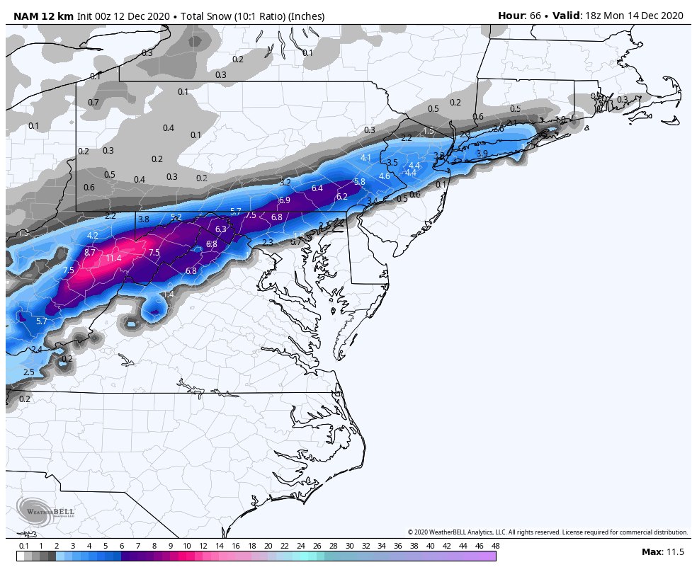
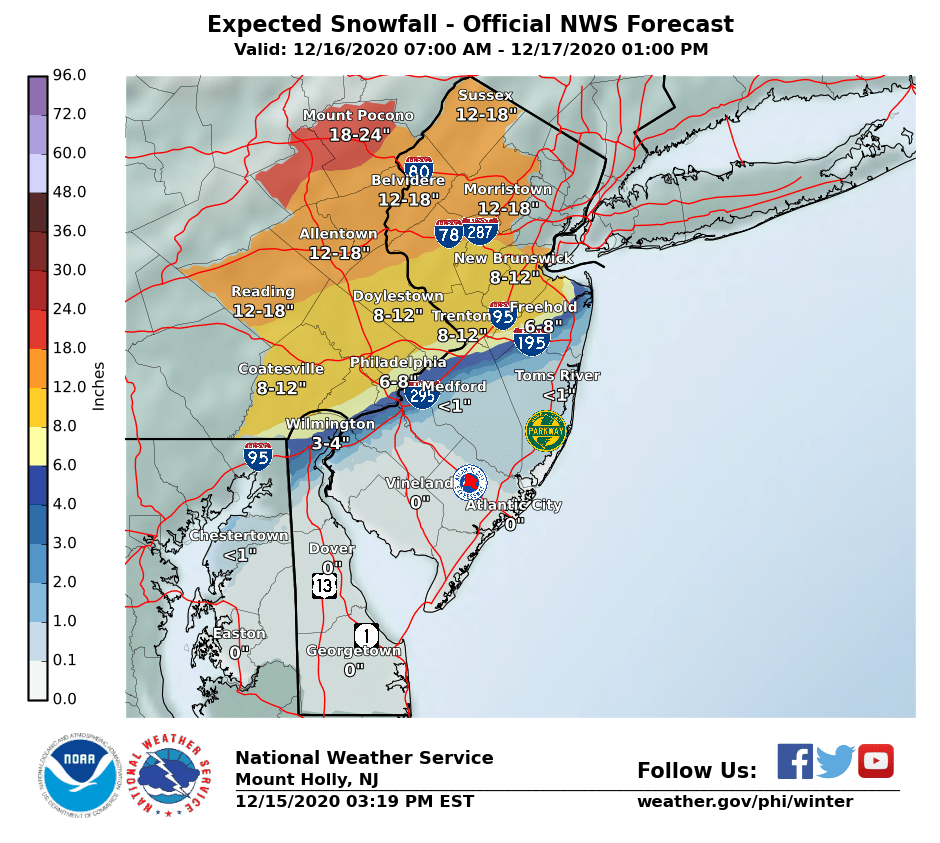
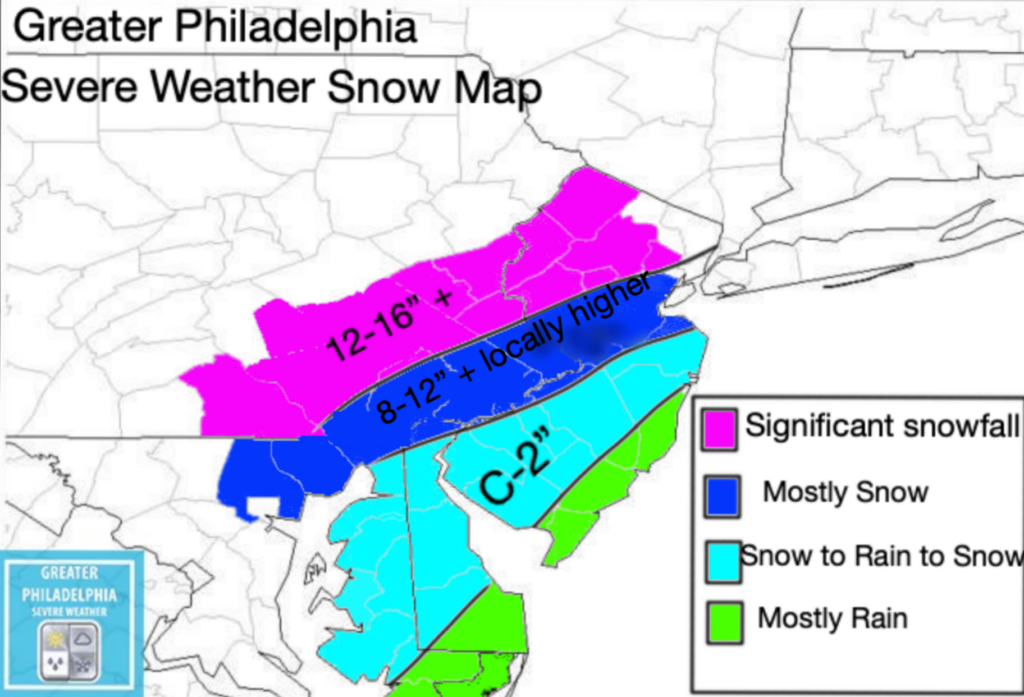
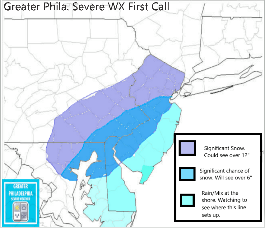
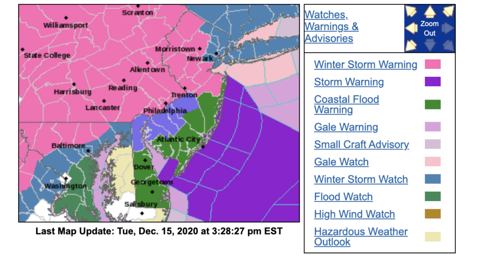
WINTER STORM WARNING NOW IN EFFECT FROM NOON WEDNESDAY TO
10 AM EST THURSDAY...
* WHAT...Heavy mixed precipitation expected. Total snow and sleet
accumulations of 6 to 12 inches. Winds gusting as high as 35
mph.
* WHERE...Portions of central, northern and northwest New Jersey
and southeast Pennsylvania.
* WHEN...From noon Wednesday to 10 AM EST Thursday.
* IMPACTS...Travel could be very difficult to impossible. The
hazardous conditions could impact the evening commute on
Wednesday and the morning commute on Thursday. The heavy snow
could result in power outages.
* ADDITIONAL DETAILS...Snow will move in from southwest to
northeast Wednesday afternoon and early evening. The snow could
become heavy at times Wednesday evening. The snow will likely
mix with and change to sleet late Wednesday evening and
Wednesday night, before ending as a period of snow on Thursday
morning.
PRECAUTIONARY/PREPAREDNESS ACTIONS...
If you must travel, keep an extra flashlight, food, and water in
your vehicle in case of an emergency.
The latest road conditions for the state you are calling from can
be obtained by calling 5 1 1.
A Winter Storm WATCH is in effect starting at 10am Wed.
Incase you didn’t know, its going to snow this week. This is something we have been talking about for the past few days, expect major to significant impact from the Nor’easter on Wednesday. At this point we are confident this storm will begin around midday/early afternoon on Wednesday and continue until early Thursday AM.
Areas near i95 will see some sleeting and mixing. We are sorry to say, but the shore points it’s mostly rain for you. The rest of the area will see significant snowfall (some areas could peak over 16” plus of snowfall). We expect the NWS to upgrade the current Winter Storm Watch to a Warning. Once that happens we will pass that information along. I will be issuing our final call map tomorrow afternoon if needed.
Our map below you will see it has a lot of different totals on it for the areas.
Purple – 12-16”+ Dark Blue Mostly 8-12+” (some areas could see higher amounts. Closer to i95 could see lower due to mixing issues) Light Blue – C-2” Green -All Rain
UPDATE: A WINTER STORM WATCH HAS BEEN ISSUED FOR WED MORNING until Thursday at 7am.
As we are following the developments in the major winter storm coming on Wed. Here is what we know now. Please NOTE the totals are the map below are just the chance of seeing that much snow. Tomorrow we will release a map with more total information.
We are gaining more and more confidence in this major winter storm that will start early afternoon on Wednesday into Thursday morning. While a lot of areas could see snowfall totals over 12″ and 16″, you have to note we are paying close attention to see how close the snow/rain mix line will set up near i95. The shore points at this point we feel will be mainly rain!
What will we see: Significant Snow- Locations seeing over 12″ are very possible. Gusty Winds Power Outages Travel Impacts during the Wed afternoon commute.
Here is our first call map. We are keeping a close eye, be prepared for changes to this map come tomorrow afternoon. We also expect the NWS to issue Watches as early as tomorrow afternoon for some areas.
While we are keeping an eye on Wednesday, we have to talk about Monday first. The latest model runs are showing some accumulation snow along i95. The models pictured below are the first of the night runs. We are going to be keeping an eye on this. Please NOTE this is NOT a forecast nor what you are going to get in your backyard. We are sharing this to point out that a threat is possible.
If this is to verify we would expect to see watches and advisory issued over the weekend. Our team will bring you the latest on these developments over the weekend.
FREEZING FOG ADVISORY IN EFFECT FROM 10 PM THIS EVENING TO
9 AM EST FRIDAY...
* WHAT...Visibility one quarter to one half mile in freezing fog and slippery roadways.
* WHERE...Portions of central, northern, northwest and southern New Jersey, east central and southeast Pennsylvania and northern Delaware.
* WHEN...From 10 PM this evening to 9 AM EST Friday.
* IMPACTS...Hazardous driving conditions due to low visibility and potential frost on bridges.
PRECAUTIONARY/PREPAREDNESS ACTIONS...
If driving, slow down, use your headlights, and leave plenty of distance ahead of you. Also, be alert for frost on bridge decks causing slippery roads.
The Delaware Valley Regional Planning Commission has issued a code orange air quality alert Sunday for The Philadelphia Metro area.
A code orange air quality alert means that air pollution concentrations within the region may become unhealthy for sensitive groups. Sensitive groups include children…people suffering from asthma… heart disease or other lung diseases…and the elderly.
The effects of air pollution can be minimized by avoiding strenuous activity or exercise outdoors.
For more information on ground-level ozone and fine particles…visit http://www.phila.gov/health/units/ams/
Early next week the United States could see TWO tropical systems along the Gulf of Mexico. In the event anything changes with this forecast we will bring you the latest information. As of this time the track is uncertain and we do expect some changes are possible. Folks along the Gulf should start to prepare for a Hurricane and Tropical Storm.
Tropical Depression 13 is expected to be upgraded to a Tropical Storm today. The forecast suggest that this storm will become a HURRICANE and is forecast to enter the Gulf of Mexico on Tuesday.
11:00 AM AST Thu Aug 20 Location: 16.0°N 52.0°W Moving: WNW at 21 mph Min pressure: 1008 mb Max sustained: 35 mph
Tropical Depression 14 has formed over the West/Central Caribbean Sea this morning. This storm is forecasted to hit the Tx/LA coast as early as Tuesday.
11:00 AM EDT Thu Aug 20 Location: 15.1°N 79.7°W Moving: W at 21 mph Min pressure: 1007 mb Max sustained: 35 mph
CURRENT WATCHS/WARNINGS: FLASH FLOOD WATCH until 12am on Aug 5th. Tropical Storm Watch
ISAIAS FORECAST TO MAKE LANDFALL TONIGHT AS A HURRICANE… …EXPECTED TO BRING STRONG WINDS AND HEAVY RAINFALL FROM THE EASTERN CAROLINAS TO THE MID-ATLANTIC COAST TONIGHT AND TUESDAY…
11:00 AM EDT Mon Aug 3 Location: 30.7°N 80.1°W Moving: N at 13 mph Min pressure: 998 mb Max sustained: 70 mph
Tropical Storm Isaias is currently located just offshore of the northeast Florida coast. The storm is expected to continue northward along the East Coast. It will likely move inland over the Carolinas this evening and approach our region by late tonight and especially Tuesday. Impacts should diminish by Wednesday morning.
The main threats with this system are heavy rainfall leading to flash flooding and some river flooding, strong winds especially near the coast, minor to potentially moderate coastal flooding, and dangerous marine conditions.
We are most concerned about flash flooding caused by 4 to 6 inches of rain, as well as strong winds along the New Jersey and Delaware coasts with wind gusts of 60 to 70 mph possible. Secondary threats include minor to locally moderate coastal flooding, especially in Chesapeake Bay, as well as the potential for isolated tornadoes. Dangerous rip currents and 8 to 12 foot seas are also expected over the waters.
Along the river and ocean expect to see 1 to 3 feet of storm surge inundation along those area. The Philadelphia metro area will have the greatest threat for FLASH FLOODING rain late tonight into tomorrow.
Tornados: The main threat of isolated tornadoes will be during the day hours on Tuesday. The best chance of an isolated tornado will be along/southeast of i95.