Nov
10
Daily Forecast Veterans Day Nov. 11, 2024
Veterans Day
A chance of rain, mainly before 7am. Cloudy through mid morning, then gradual clearing, with a high near 68.
Monday Night
Clear, with a low around 45

Veterans Day
A chance of rain, mainly before 7am. Cloudy through mid morning, then gradual clearing, with a high near 68.
Monday Night
Clear, with a low around 45
Enjoy the long weekend! Rain yes rain is possible Sunday night. It could cause major issues due to the current lack of rain!
Saturday
Sunny, with a high near 55. North wind around 5 mph.
Saturday Night
Mostly clear, with a low around 33. Calm wind.
Sunday
A slight chance of rain after 4pm. Increasing clouds, with a high near 61. Light southwest wind increasing to 5 to 10 mph in the morning. Chance of precipitation is 20%.
Sunday Night
Rain, mainly after 7pm. Low around 53

Have an awesome Friday!
Friday
Sunny, with a high near 68. West wind 5 to 10 mph, with gusts as high as 30 mph.
Friday Night
Mostly clear, with a low around 40
Have an awesome Thursday!
Thursday
A slight chance of showers before 9am. Mostly cloudy, then gradually becoming sunny, with a high near 77. Northwest wind 5 to 10 mph. Chance of precipitation is 20%.
Thursday Night
Clear, with a low around 44.
Have a great day! If you didn’t vote STFU
Wednesday
Partly sunny, with a high near 80. Southwest wind 10 to 15 mph.
Wednesday Night
Mostly cloudy, with a low around 60.

GET OUT AND VOTE!
Tuesday
Partly sunny, with a high near 73. Southwest wind 5 to 15 mph.
Tuesday Night
Partly cloudy, with a low around 58
Have a great day!
Monday
Partly sunny, with a high near 63. Northeast wind 5 to 10 mph becoming southeast in the morning.
Monday Night
Mostly cloudy, with a low around 51
Have a great weekend!
Saturday
Sunny, with a high near 61. Northwest wind 5 to 10 mph.
Saturday night
Mostly clear, with a low around 35. North wind around 5 mph.
Sunday
Sunny, with a high near 59. North wind around 5 mph becoming calm in the afternoon.
Sunday Night
Partly cloudy, with a low around 38
Have a great Friday! Today is day one of a new chapter! Make this month a great one!
Friday
A chance of sprinkles with a slight chance of showers before noon. Cloudy, then gradual clearing during the afternoon, with a high near 79. Southwest wind 10 to 15 mph. Chance of precipitation is 20%.
Friday Night
Clear, with a low around 43
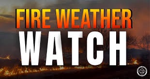
FIRE WEATHER WATCH IN EFFECT FROM FRIDAY AFTERNOON THROUGH
FRIDAY EVENING FOR GUSTY WINDS AND LOW RELATIVE HUMIDITY FOR
PORTIONS OF EASTERN AND SOUTHEASTERN PENNSYLVANIA...

The National Weather Service in Mount Holly has issued a Fire
Weather Watch for gusty winds and low relative humidity, which is
in effect from Friday afternoon through Friday evening.

* AFFECTED AREA...Carbon, Monroe, Berks, Lehigh, Northampton,
  Delaware, Philadelphia, Western Chester, Eastern Chester,
  Western Montgomery, Eastern Montgomery, Upper Bucks and Lower
  Bucks.

* TIMING...From Friday afternoon through Friday evening.

* WINDS...West 15 to 20 mph with gusts up to 30 mph.

* RELATIVE HUMIDITY...As low as 28 percent.

* TEMPERATURES...In the mid to upper 70s.

* IMPACTS...Any fire that develops will catch and spread
  quickly. Outdoor burning is not recommended.

PRECAUTIONARY/PREPAREDNESS ACTIONS...

A Fire Weather Watch means that critical fire weather conditions
are forecast to occur due to a combination of strong winds, low
relative humidities, and dry fuels. Listen for later forecasts
and possible Red Flag Warnings.

For more information about wildfire danger, burn restrictions,
and wildfire prevention and education, please visit your state
forestry or environmental protection website.