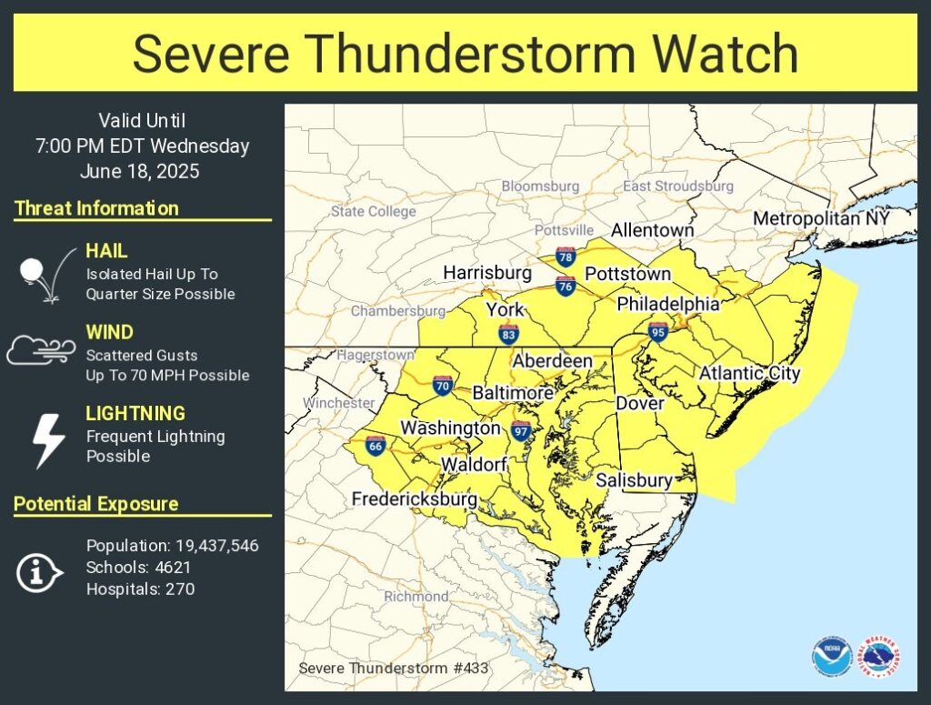
Severe Thunderstorm Watch for portions of District Of Columbia Delaware Eastern Maryland Southern New Jersey Southeast Pennsylvania Northern Virginia Coastal Waters
Effective this Wednesday afternoon and evening from 1245 PM until 700 PM EDT.
Primary threats include… Scattered damaging wind gusts to 70 mph possible
SUMMARY…Scattered thunderstorms will spread eastward across the watch area through the afternoon. The strongest cells will be capable of localized damaging wind gusts.
The severe thunderstorm watch area is approximately along and 80 statute miles east and west of a line from 30 miles northwest of Philadelphia PA to 55 miles southeast of Washington DC. For a complete depiction of the watch see the associated watch outline update (WOUS64 KWNS WOU3).
PRECAUTIONARY/PREPAREDNESS ACTIONS…
REMEMBER…A Severe Thunderstorm Watch means conditions are favorable for severe thunderstorms in and close to the watch area. Persons in these areas should be on the lookout for threatening weather conditions and listen for later statements and possible warnings. Severe thunderstorms can and occasionally do produce tornadoes.
&&
OTHER WATCH INFORMATION…CONTINUE…WW 432…
AVIATION…A few severe thunderstorms with hail surface and aloft to 1 inch. Extreme turbulence and surface wind gusts to 60 knots. A few cumulonimbi with maximum tops to 500. Mean storm motion vector 27025.
Showers and thunderstorms likely, then showers and possibly a thunderstorm after 5pm. Areas of fog before 9am. High near 86. Southwest wind 5 to 10 mph.
Wednesday Night
Showers and thunderstorms likely. Mostly cloudy, with a low around 72. Southwest wind 5 to 10 mph.
AIR QUALITY ALERT IS IN EFFECT FOR THURSDAY JUNE 12...

The Delaware Valley Regional Planning Commission has issued
a code orange air quality alert Thursday for The Philadelphia
Metro area.

A code orange air quality alert means that air pollution
concentrations within the region may become unhealthy for
sensitive groups. Sensitive groups include children...people
suffering from asthma... heart disease or other lung
diseases...and the elderly. The effects of air pollution can
be minimized by avoiding strenuous activity or exercise outdoors.