* WHAT...Heavy snow expected. Total snow accumulations of 16 to 22
inches. Winds gusting as high as 35 mph.
* WHERE...Portions of central, northern and northwest New Jersey
and southeast Pennsylvania.
* WHEN...From 5 PM this afternoon to 1 PM EST Tuesday.
* IMPACTS...Travel could be very difficult to impossible. The
hazardous conditions could impact the morning or evening
commute.
* ADDITIONAL DETAILS...Snow develops late this afternoon and
will last through Monday night or early Tuesday. Snow may be
heavy at times on Monday.
PRECAUTIONARY/PREPAREDNESS ACTIONS...
If you must travel, keep an extra flashlight, food, and water in
your vehicle in case of an emergency.
The latest road conditions for the state you are calling from can
be obtained by calling 5 1 1.
As we move into now casting on this storm. Here are some of the latest details we have.
Snow will begin to move into the area over the next few hours. We expect to see a minor lull in the overnight hours from about 3am-7am. Total snowfall amounts will be between 2-5” from this timeframe. Tomorrow the snow is really going to get going between 7-10am until about 10-11pm and areas will see snowfall rates of over 1”+ an hour at times. Try to avoid any travel on Monday during the storm.
Tuesday morning the snow will taper off than it is possible Tuesday afternoon a few additional snow showers are possible. We are advising everyone to stay off the roads tomorrow during the storm. One thing to note is that while this is now a nowcasting event. We are watching hour by hour the progress as well as any changes to the forecast. In the event the warmer air moves into the mid level there is a chance of mixing and dry air reducing total accumulation. While at this point not certain it will happen but the possibility is there and we don’t want to rule it out.
The NWS has updated the winter storm warning which now calls for 13-18” of snow with wind gust as high as 35mph. This will expire at 1pm Tuesday.
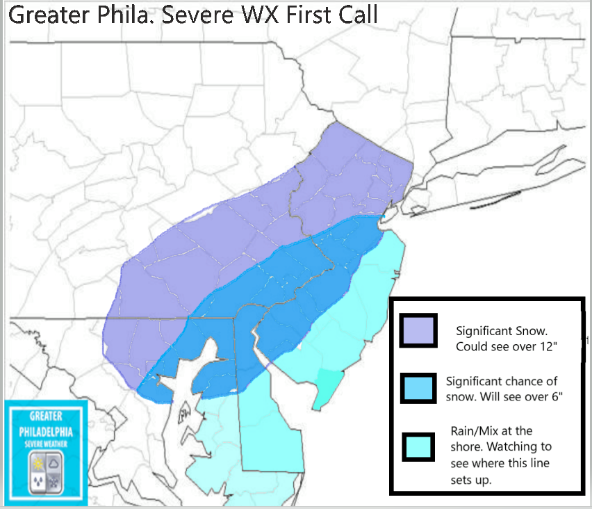
Philadelphia | Lower Bucks | Trenton | Princeton Significant snowfall is expected in these areas. 10-14” + Could see additional snowfall where CCB sets up.
Central/ Upper Bucks 10-14” could see higher amounts depending on ccb placement.
Allentown | Lehigh Valley 12-18”
Lancaster | KOP 10-14” could see more depending on setup.
Atlantic City | Wildwood 1-3” Snow to mix to rain and possibly ending as snow on the backend.
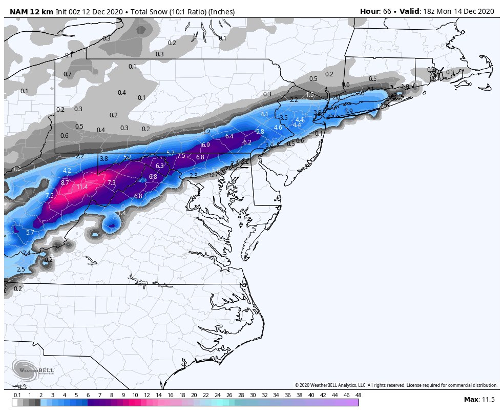
The National Weather Service has upgraded the Winter Storm Watch to a Winter Storm Warning. Here is the NWS latest snowmap
WINTER STORM WARNING IN EFFECT FROM 5 PM SUNDAY TO 1 PM EST
TUESDAY...
* WHAT...Heavy snow expected. Total snow accumulations of 11 to
15 inches. Winds gusting as high as 35 mph.
* WHERE...Portions of central, northern and northwest New Jersey
and east central and southeast Pennsylvania.
* WHEN...From 5 PM Sunday to 1 PM EST Tuesday.
* IMPACTS...Travel could be very difficult to impossible. The
hazardous conditions could impact the morning or evening
commute.
PRECAUTIONARY/PREPAREDNESS ACTIONS...
If you must travel, keep an extra flashlight, food, and water in
your vehicle in case of an emergency.
The latest road conditions for the state you are calling from can
be obtained by calling 5 1 1.
As you have heard we are tracking a major winter storm that will begin late tomorrow afternoon and last until Tuesday morning. This storm will produce significant snowfall across our viewing area. Take account the high snowfall totals with gusty winds power outages are very possible as the low starts to crank off shore and the winds really pick up.
The snow will begin after 4pm and continue through about dinner time on Tuesday. We expect the heaviest snowfall to happen between late morning/Midday Monday until around 9am on Tuesday morning. As we have mentioned winds will be gusty during the storm with winds 10-20mph and sustained guest up to 50mph is possible. Could some areas see a blizzard warning, it is possible but at this point no warnings are in effect. Blowing and drifting snow will cause travel issues. Also travel should be limited during the storm as visibility will be less than 1 miles at times. We might we have some THUNDERSNOW along the Philadelphia area.
Philadelphia | Lower Bucks | Trenton | Princeton Significant snowfall is expected in these areas. 8-12” but some areas could see more than 16” if bands setup.
Central/ Upper Bucks 6-12” could see higher amounts depending on pending.
Allentown | Lehigh Valley 4-6” Snow with some sleet possible.
Lancaster | KOP 8-12” could see more depending on setup.
Atlantic City | Wildwood 1-3” Snow to mix to rain and possibly ending as snow on the backend.
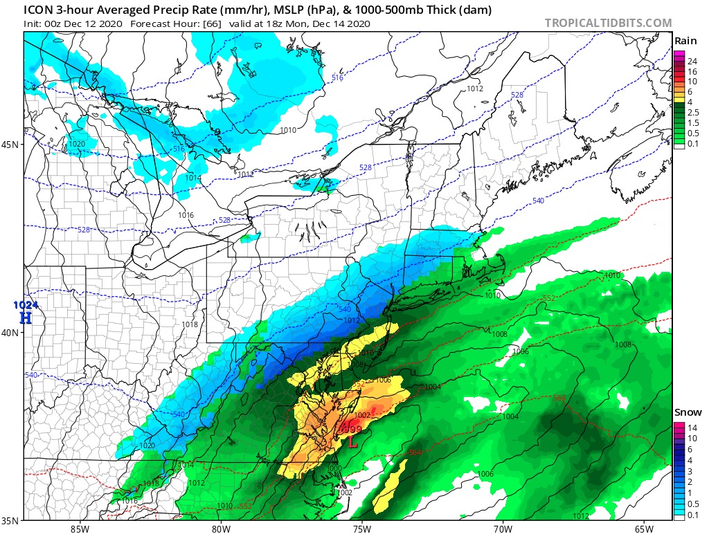
We are tracking a Major Winter Storm that will bring Snow, Sleet and Freezing Rain to parts of the area. While we are still working to determine a final track. At this hour we can say that confidence is growing that this storm will cause impact to our area Sunday afternoon until Tuesday morning. While the snow will begin on Sunday afternoon. A large amount of snow could fall between Sunday night and Monday, with additional snowfall through Tuesday as the storm strengthens as it moves to our north. Some areas could see as much as a foot of snow come Tuesday.
SNOW– At this time we are going with a MODERATE threat of snow over the timeframe stated above.
Freezing Rain– SLIGHT chance locations within the area could see freezing rain/wintery mix. If this does happen it would be locations closest to the shore points.
WIND/POWER Outages– ENHANCE Threat of gusty winds and SLIGHT chance of power outages throughout the storm. Areas to the north could see blizzard warnings due to high winds as the storm cranks off the coast. Confidence is LOW that we will see blizzard warnings issued for our area at this time.
WINTER STORM WATCH IN EFFECT FROM SUNDAY AFTERNOON THROUGH
LATE MONDAY NIGHT...
* WHAT...Heavy snow possible. Total snow accumulations over 7
inches possible. Winds could gust as high as 50 mph creating
significant blowing and drifting of snow.
* WHERE...Portions of central, northern and southern New Jersey
and southeast Pennsylvania.
* WHEN...From Sunday afternoon through late Monday night.
* IMPACTS...Travel could be very difficult. The hazardous
conditions could impact the Monday evening commute.
* ADDITIONAL DETAILS...Snow will develop west to east late Sunday
and last through late Monday or early Tuesday. A period of
wintry mix or rain could occur Sunday night and Monday morning,
especially along and near the coast, before turning back to snow
Monday afternoon. The highest snowfall rates are most likely to
occur late Monday.
SNOW MAP- We will have a snow map released mid day tomorrow. Our team is working around the clock to bring you the latest information on this upcoming storm. Now is a great time to prepare for a long duration winter storm.
PLEASE remember while this storm is a long duration, it does NOT mean we will have a substantial amount of snow.
Lower Makefield Township Animal Control Officer is seeking help to find the people who have dumped two bulldogs at Macclesfield this morning. Per a posting in a local Facebook group, the male is intact and the female dog is either a breeder or just had puppies, and is very depressed. If anyone sees bulldog puppies for sale on any local sites, please report it to LMT ACO Jamie Fazzalore-Truelove through the non-emergency line at 215-493-4011 and ask for the ACO to contact you.
If anyone knows of any information or tips to find who did this please contact the ACO at the number above. Below are photos of the two dogs who were dumped this morning. We have heard that both dogs are at at the BCSPCA in Lahaska.
A FLOOD WATCH and WIND Advisory will both go into effect at 4pm this afternoon.
FLOOD WATCH IN EFFECT FROM THIS AFTERNOON THROUGH FRIDAY
MORNING...
The National Weather Service in Mount Holly has expanded the
* Flood Watch to include portions of northern Delaware...New
Jersey...and southeast Pennsylvania...including the following
areas...in northern Delaware...New Castle. In New Jersey...Mercer,
Middlesex, and Somerset. In southeast Pennsylvania...Delaware,
Eastern Montgomery, Lower Bucks, and Philadelphia.
* From this afternoon through Friday morning
* Heavy rain will move into the region late Thursday and Thursday
night, with between 1 and 3 inches of rain over the region and as
much as 3 to 4 inches of rain over the southern Poconos.
* Excessive rainfall and snowmelt will result in rises on rivers and
streams.
PRECAUTIONARY/PREPAREDNESS ACTIONS...
A Flood Watch means there is a potential for flooding based on
current forecasts. You should monitor later forecasts and be alert
for possible flood warnings. Those living in areas prone to flooding
should be prepared to take action should flooding develop.
WIND ADVISORY
WIND ADVISORY NOW IN EFFECT FROM 6 PM THIS EVENING TO 6 AM EST
FRIDAY...
* WHAT...South winds 20 to 30 mph with gusts up to 55 mph
expected.
* WHERE...Portions of central, northern and southern New Jersey,
southeast Pennsylvania, northeast Maryland and central,
northern and southern Delaware.
* WHEN...From 6 PM this evening to 6 AM EST Friday.
* IMPACTS...Gusty winds could blow around unsecured objects.
Tree limbs could be blown down and a few power outages may
result.
* ADDITIONAL DETAILS...Secure any outdoor holiday decorations
before the strong winds arrive.
PRECAUTIONARY/PREPAREDNESS ACTIONS...
Use extra caution when driving, especially if operating a high
profile vehicle. Secure outdoor objects.
We are watching for some severe weather on Christmas Eve (Thursday) into Christmas Day. While it will not be a white Christmas for us, we need to plan for what is possibly going to come. A strong cold front will move across the area bringing heavy winds (40-50mph+), heavy rain, thunderstorms or two and a flash freeze is possible. After the cold front pushes through we will see temperatures drop 20-30º within a few hours. As you can see below is the GFS temperature model and you can see that difference as the cold front pushes across the area. Flooding is also possible due to snowpack. If you have sewer drains in front of your house, it might be a great idea to clear snow from them to allow water to flow into the drains.
Prepare for possible power outages, a flash freeze and heavy rain on Christmas Eve/Day. Santa and his team are preparing and they are confident he will be able to make it to everyones home this Christmas.
Middlesex-Mercer-Delaware-Philadelphia-Eastern Chester-
Eastern Montgomery-Lower Bucks-
Including the cities of New Brunswick, Trenton, Media,
Philadelphia, West Chester, Kennett Square, Norristown, Lansdale,
Morrisville, and Doylestown
318 AM EST Wed Dec 16 2020
* WHAT...Heavy snow mixed with sleet expected. Total snow and
sleet accumulations of 6 to 12 inches. Winds gusting as high as
40 mph.
* WHERE...Portions of central and northern New Jersey and
southeast Pennsylvania.
* WHEN...From noon today to 10 AM EST Thursday.
* IMPACTS...Travel could be very difficult to impossible. The
hazardous conditions will impact the evening commute tonight and
the morning commute on Thursday. Heavy snow and gusty winds
could result in power outages.
* ADDITIONAL DETAILS...Snow will move in from southwest to
northeast this afternoon and early evening, and will be heavy at
times this evening. The snow will likely mix with and change to
sleet this evening, before ending as a period of snow on
Thursday morning.
PRECAUTIONARY/PREPAREDNESS ACTIONS...
If you must travel, keep an extra flashlight, food, and water in
your vehicle in case of an emergency.
The latest road conditions for the state you are calling from can
be obtained by calling 5 1 1.
WINTER STORM WARNING NOW IN EFFECT FROM NOON WEDNESDAY TO
10 AM EST THURSDAY...
* WHAT...Heavy mixed precipitation expected. Total snow and sleet
accumulations of 6 to 12 inches. Winds gusting as high as 35
mph.
* WHERE...Portions of central, northern and northwest New Jersey
and southeast Pennsylvania.
* WHEN...From noon Wednesday to 10 AM EST Thursday.
* IMPACTS...Travel could be very difficult to impossible. The
hazardous conditions could impact the evening commute on
Wednesday and the morning commute on Thursday. The heavy snow
could result in power outages.
* ADDITIONAL DETAILS...Snow will move in from southwest to
northeast Wednesday afternoon and early evening. The snow could
become heavy at times Wednesday evening. The snow will likely
mix with and change to sleet late Wednesday evening and
Wednesday night, before ending as a period of snow on Thursday
morning.
PRECAUTIONARY/PREPAREDNESS ACTIONS...
If you must travel, keep an extra flashlight, food, and water in
your vehicle in case of an emergency.
The latest road conditions for the state you are calling from can
be obtained by calling 5 1 1.