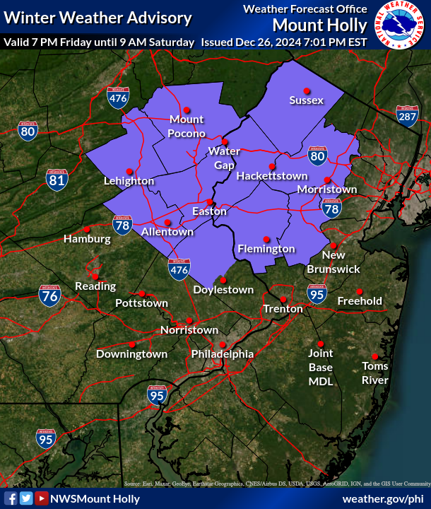
ALERT Increased Risk of Fire Spread on Saturday

Increased Risk of Fire Spread on Saturday…

There continues to be an increased risk of fire spread on Saturday. Relative humidity values Saturday afternoon will drop to 25 to 35 percent across much of the area. These low relative humidity values will combine with northwest winds around 15 mph with gusts up to 25 mph, and even occasionally as high as 30 mph, temperatures in the mid to upper 60s, and abundant sunshine. These conditions will support the spread of any fires that ignite, which could quickly become difficult to control.

Outdoor burning is strongly discouraged. Be sure to properly extinguish or dispose of any potential ignition sources, including smoking materials such as cigarette butts. Refer to your state’s forest fire management agency for more information on burn restrictions in your local area.

Relative humidity values will be lower on Sunday, generally ranging from 20 to 30 percent, but winds will be much lighter. Burn restrictions may still be in place given the very dry conditions and lack of any recent rainfall.

FROST ADVISORY In Effect midnight until 9am Friday

FROST ADVISORY IN EFFECT FROM MIDNIGHT TONIGHT TO 9 AM EDT
FRIDAY...

* WHAT...Temperatures ranging from 34 to 37 degrees will result in
areas of frost formation.

* WHERE...Portions of central, northern, northwest, and southern New
Jersey and east central, northeast, and southeast Pennsylvania.

* WHEN...From midnight tonight to 9 AM EDT Friday.

* IMPACTS...Frost could harm sensitive outdoor vegetation. Sensitive
outdoor plants may be killed if left uncovered.

PRECAUTIONARY/PREPAREDNESS ACTIONS...

Take steps now to protect tender plants from the cold.

Flood Watch has been issued 2:00 am Sunday until 2:00 am Monday


FLOOD WATCH IN EFFECT FROM 2 AM EDT SUNDAY THROUGH LATE SUNDAY
NIGHT...

* WHAT...Flooding caused by excessive rainfall is possible.

* WHERE...Portions of northern Delaware, including the following
area, New Castle, New Jersey, including the following areas,
Camden, Gloucester, Hunterdon, Mercer, Middlesex, Morris,
Northwestern Burlington, Salem, Somerset, Sussex, Warren and
Western Monmouth, and Pennsylvania, including the following areas,
Berks, Delaware, Eastern Chester, Eastern Montgomery, Lehigh,
Lower Bucks, Northampton, Philadelphia, Upper Bucks, Western
Chester and Western Montgomery.

* WHEN...From 2 AM EDT Sunday through late Sunday night.

* IMPACTS...Excessive runoff may result in flooding of rivers, creeks, streams, and other low-lying and flood-prone locations. Flooding may occur in poor drainage and urban areas.

* ADDITIONAL DETAILS...
- Heavy rain and thunderstorms associated with an approaching
cold front will produce widespread rainfall amounts of 1 to 3 inches with locally higher amounts of 4 inches or more possible.
- http://www.weather.gov/safety/flood

PRECAUTIONARY/PREPAREDNESS ACTIONS...

You should monitor later forecasts and be alert for possible Flood
Warnings. Those living in areas prone to flooding should be prepared
to take action should flooding develop.

TORNADO WATCH IN EFFECT UNTIL 10pm

Update: the TORNADO WATCH IS NOW IN EFFECT UNTIL 10pm 

* Tornado Watch for portions of
District Of Columbia
Delaware
Central and Eastern Maryland
Much of New Jersey
Southeast New York
Central and Eastern Pennsylvania
Eastern and Northern Virginia
Coastal Waters

* Effective this Friday morning and afternoon from 615 AM until
200 PM EDT.

* Primary threats include...
A few tornadoes possible
Isolated damaging wind gusts to 60 mph possible

SUMMARY...Isolated to widely scattered thunderstorms are forecast to
develop this morning into the early afternoon as a warm front
advances northward across the Watch area. Several supercells will
likely develop and the stronger storms will potentially yield a risk
for tornadoes. Isolated damaging gusts may also accompany the more
intense storms.

WIND ADVISORY IS IN EFFECT

WIND ADVISORY IN EFFECT FROM 6 AM TO 8 PM EDT FRIDAY...

* WHAT...Southeast winds 10 to 20 mph with gusts up to occasional
  gusts up to 45 to 50 mph expected.

* WHERE...Portions of New Jersey and southeast Pennsylvania.

* WHEN...From 6 AM to 8 PM EDT Friday.

* IMPACTS...Gusty winds will blow around unsecured objects. Frequent
  gusts of 35 to 45 mph winds will be possible which when combined
  with saturated grounds will have the potential to bring down
  trees. Tree limbs could be blown down and a few power outages may
  result.

PRECAUTIONARY/PREPAREDNESS ACTIONS...

Winds this strong can make driving difficult, especially for high
profile vehicles. Use extra caution.

Flood Watch has been issued fro Tuesday Afternoon into Wednesday Morning


* WHAT...Flooding caused by excessive rainfall is possible.

* WHERE...Portions of northern Delaware, including the following
area, New Castle, New Jersey, including the following areas,
Camden, Coastal Ocean, Eastern Monmouth, Gloucester, Hunterdon,
Mercer, Middlesex, Northwestern Burlington, Ocean, Salem,
Somerset, Southeastern Burlington and Western Monmouth, and
southeast Pennsylvania, including the following areas, Delaware,
Eastern Chester, Eastern Montgomery, Lower Bucks, Philadelphia,
Upper Bucks, Western Chester and Western Montgomery.

* WHEN...From Tuesday afternoon through Wednesday morning.

* IMPACTS...Excessive runoff may result in flooding of rivers,
creeks, streams, and other low-lying and flood-prone locations.
Flooding may occur in poor drainage and urban areas.

* ADDITIONAL DETAILS...
- A cold front will approach from the north and west on Tuesday
and will cross the region Tuesday night. This front will
interact with tropical moisture associated with Hurricane
Debby to result in heavy downpours over the area. Rainfall
totals will average 1 to 2 inches, but locally higher amounts
are possible.

SEVERE THUNDERSTORM WATCH and FLOOD WATCH have been issued

A severe thunder storm watch and flood watch have been issued until 9pm. The heat advisory is still in effect until 8pm

FLOOD WATCH IN EFFECT UNTIL MIDNIGHT EDT TONIGHT...

* WHAT...Flash flooding caused by excessive rainfall is possible.

* WHERE...Portions of northern Delaware, including the following
area, New Castle, New Jersey, including the following areas,
Camden, Coastal Ocean, Eastern Monmouth, Gloucester, Hunterdon,
Mercer, Middlesex, Morris, Northwestern Burlington, Ocean, Salem,
Somerset, Southeastern Burlington, Sussex, Warren and Western
Monmouth, and Pennsylvania, including the following areas, Berks,
Carbon, Delaware, Eastern Chester, Eastern Montgomery, Lehigh,
Lower Bucks, Monroe, Northampton, Philadelphia, Upper Bucks,
Western Chester and Western Montgomery.

* WHEN...Until midnight EDT tonight.

* IMPACTS...Excessive runoff may result in flooding of rivers,
creeks, streams, and other low-lying and flood-prone locations.

* ADDITIONAL DETAILS...
- Storms this afternoon will be capable of heavy rain. Some
locations could get multiple rounds of storms, increasing the
potential for flash flooding, especially in urban areas and
other areas with poor drainage. Although storms may linger
past midnight, overnight storms aren`t expected to have as
much potential for heavy rainfall.
- http://www.weather.gov/safety/flood

PRECAUTIONARY/PREPAREDNESS ACTIONS...

You should monitor later forecasts and be prepared to take action
should Flash Flood Warnings be issued.

HEAT ADVISORY IN EFFECT UNTIL 8PM Tonight

..HEAT ADVISORY IN EFFECT FROM 11 AM THIS MORNING TO 8 PM EDT THIS
EVENING...

* WHAT...Heat index values up to 101 expected.

* WHERE...In Delaware, New Castle County. In New Jersey, Mercer,
Camden, Gloucester, and Northwestern Burlington Counties. In
Pennsylvania, Delaware, Eastern Chester, Eastern Montgomery, Lower
Bucks, and Philadelphia Counties.

* WHEN...From 11 AM this morning to 8 PM EDT this evening.

* IMPACTS...Hot temperatures and high humidity may cause heat
illnesses.

PRECAUTIONARY/PREPAREDNESS ACTIONS...

Drink plenty of fluids, stay in an air-conditioned room, stay out of
the sun, and check up on relatives and neighbors.

Excessive Heat Warning in effect from 11 am until 8pm Wednesday

EXCESSIVE HEAT WARNING IN EFFECT FROM 11 AM TO 8 PM EDT WEDNESDAY...

* WHAT...Dangerously hot conditions with heat index values up to 105 expected.

* WHERE...In New Jersey, Mercer, Camden, Gloucester, and Northwestern Burlington Counties. In Pennsylvania, Delaware, Eastern Montgomery, Lower Bucks, and Philadelphia Counties.

* WHEN...From 11 AM to 8 PM EDT Wednesday.

* IMPACTS...Heat related illnesses increase significantly during extreme heat and high humidity events.

PRECAUTIONARY/PREPAREDNESS ACTIONS...

Drink plenty of fluids, stay in an air-conditioned room, stay out of the sun, and check up on relatives and neighbors.

Do not leave young children and pets in unattended vehicles. Car interiors will reach lethal temperatures in a matter of minutes.

To reduce risk during outdoor work, the Occupational Safety and Health Administration recommends scheduling frequent rest breaks in shaded or air conditioned environments. Anyone overcome by heat should be moved to a cool and shaded location. Heat stroke is an emergency! Call 9 1 1.

HEAT ADVISORY IN EFFECT UNTIL 8PM Friday

…HEAT ADVISORY IN EFFECT FROM 10 AM THURSDAY TO 8 PM EDT FRIDAY…

  • WHAT…Heat index values up to 102 expected.
  • WHERE…Portions of northern Delaware, central, northern, and southern New Jersey, and southeast Pennsylvania.
  • WHEN…From 10 AM Thursday to 8 PM EDT Friday.
  • IMPACTS…Hot temperatures and high humidity may cause heat illnesses.

PRECAUTIONARY/PREPAREDNESS ACTIONS…

Drink plenty of fluids, stay in an air-conditioned room, stay out of the sun, and check up on relatives and neighbors.

To reduce risk during outdoor work, the Occupational Safety and Health Administration recommends scheduling frequent rest breaks in shaded or air conditioned environments. Anyone overcome by heat should be moved to a cool and shaded location. Heat stroke is an emergency! Call 9 1 1.