Daily Forecast Monday April 15, 2024
Have a GREAT Monday!
Monday
Mostly sunny, with a high near 77. West wind 5 to 15 mph.
Monday Night
Mostly clear, with a low around 49
Have a GREAT Monday!
Monday
Mostly sunny, with a high near 77. West wind 5 to 15 mph.
Monday Night
Mostly clear, with a low around 49
Have a great weekend!
Saturday
A chance of showers, mainly before 9am. Cloudy, then gradually becoming mostly sunny, with a high near 56. Breezy, with a west wind 20 to 25 mph, with gusts as high as 40 mph. Chance of precipitation is 30%. New precipitation amounts of less than a tenth of an inch possible.
Saturday Night
Mostly clear, with a low around 43. West wind 5 to 15 mph, with gusts as high as 25 mph.
Sunday
A slight chance of showers and thunderstorms after 2pm. Mostly sunny, with a high near 71. Southwest wind 5 to 15 mph. Chance of precipitation is 20%.
Sunday Night
A chance of showers and thunderstorms, mainly between 8pm and 2am. Mostly cloudy, with a low around 57
Be alert for flooding potential this afternoon.
Friday
Showers and thunderstorms likely before noon, then a chance of showers between noon and 2pm, then a slight chance of showers and thunderstorms after 2pm. Mostly cloudy, with a high near 63. Breezy, with a southwest wind 15 to 20 mph, with gusts as high as 35 mph.
Friday Night
A slight chance of showers and thunderstorms before 7pm, then a slight chance of showers after midnight. Mostly cloudy, with a low around 46.
Be alert for flooding potential this afternoon.
Thursday
Showers likely, mainly after 4pm. Patchy fog before 11am. Otherwise, cloudy, with a high near 72. Breezy, with an east wind 5 to 10 mph becoming south 15 to 20 mph in the afternoon. Chance of precipitation is 60%. New precipitation amounts of less than a tenth of an inch possible.
Thursday Night
Showers and possibly a thunderstorm. Some of the storms could produce heavy rain. Low around 60. Windy, with a south wind 25 to 30 mph. Chance of precipitation is 100%. New rainfall amounts between a half and three quarters of an inch possible.
Have a great Day!
Wednesday
A chance of showers, mainly before 2pm. Mostly cloudy, with a high near 65.
Wednesday Night
A slight chance of showers. Mostly cloudy, with a low around 54. East wind around 5 mph.
Today will be a great weather day!
Tuesday
Partly sunny, with a high near 76. Calm wind becoming north around 5 mph.
Tuesday Night
A chance of showers after 3am. Mostly cloudy, with a low around 53. Southeast wind around 5 mph
ECLIPSE INFO
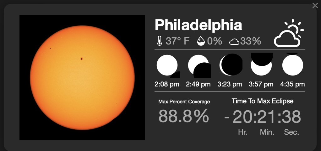
In Philadelphia, the eclipse will occur from 2:08 p.m. until 4:35 p.m., peaking at 3:23 p.m.
A solar eclipse occurs when the moon comes between the earth and the sun. During a total solar eclipse, the moon blocks the light coming in from the sun and appears to cover up the sun entirely. This will give viewers a glimpse of the sun’s outer atmosphere, known as the corona.

NASA WALLOPS LAUNCHES MONDAY
During the Eclipse today you will be able to see 3 rockets launched from Wallops.
Wallops Flight Facility on Virginia’s Eastern Shore will launch 3 rockets during the solar eclipse to study how Earth’s upper atmosphere is affected when sunlight dims for a moment over part of the planet.
Those rockets will launch at three different times — 45 minutes before the total solar eclipse, during it, and then 45 minutes after the peak local eclipse, and they are expected to reach a maximum altitude of 260 miles. The launch window opens at 2:40 p.m. EDT, with targeted launch times for the three rockets being 2:40 p.m., 3:20 p.m. and 4:05 p.m., but those times are subject to change.
NASA said the three launches are important to gather data on how the sun’s disappearance affects the ionosphere, “creating disturbances that have the potential to interfere with our communications.”
Have a great day!
Monday
Mostly sunny, with a high near 64. Calm wind becoming west around 5 mph in the afternoon.
Monday Night
Partly cloudy, with a low around 47
Have a great weekend!
Saturday
Partly sunny, with a high near 53. Northwest wind 10 to 15 mph, with gusts as high as 25 mph.
Saturday Night
Mostly clear, with a low around 37. Northwest wind 5 to 10 mph.
Sunday
Mostly sunny, with a high near 55. North wind 5 to 10 mph.
Sunday Night
Mostly clear, with a low around 36. Calm wind.
Have a great Friday!
Friday
Isolated showers before 7am, then isolated showers after 2pm. Mostly cloudy, with a high near 50.
Friday Night
Isolated showers before 9pm. Partly cloudy, with a low around 37. West wind around 10 mph.