Daily Forecast Thursday April 11, 2024

Be alert for flooding potential this afternoon.

Thursday

Showers likely, mainly after 4pm. Patchy fog before 11am. Otherwise, cloudy, with a high near 72. Breezy, with an east wind 5 to 10 mph becoming south 15 to 20 mph in the afternoon. Chance of precipitation is 60%. New precipitation amounts of less than a tenth of an inch possible.

Thursday Night

Showers and possibly a thunderstorm. Some of the storms could produce heavy rain. Low around 60. Windy, with a south wind 25 to 30 mph. Chance of precipitation is 100%. New rainfall amounts between a half and three quarters of an inch possible.

Flood Watch and Coast Flood Watch in effect

COASTAL FLOOD ADVISORY IN EFFECT UNTIL 1 PM EDT THIS AFTERNOON


* WHAT…Up to one foot of inundation above ground level in low- lying areas near shorelines and tidal waterways.


* WHERE…In New Jersey, Gloucester, Camden and Northwestern Burlington. In Pennsylvania, Delaware, Philadelphia and Lower Bucks.

* WHEN…Until 1 PM EDT this afternoon.

* IMPACTS…At this level, flooding begins on the most vulnerable roads along tidal waterways. Some partial or full road closures are possible.

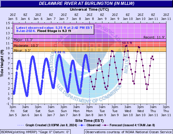
* ADDITIONAL DETAILS…Additional minor flooding is forecast with the high tide Thursday morning, and another advisory may be issued for that later today.

PRECAUTIONARY/PREPAREDNESS ACTIONS – If travel is required, allow extra time as some roads may be closed. Do not drive around barricades or through water of unknown depth. Take the necessary actions to protect flood-prone property.

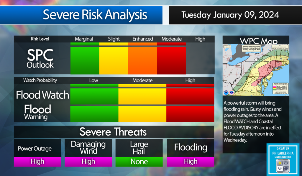
Flood Watch In Effect Until Thursday Afternoon:

FLOOD WATCH REMAINS IN EFFECT THROUGH THURSDAY AFTERNOON…

* WHAT…Flooding caused by excessive rainfall continues to be possible.

* WHERE…Portions of northern Delaware, including the following area, New Castle, New Jersey, including the following areas, Camden, Gloucester, Hunterdon, Mercer, Middlesex, Morris, Northwestern Burlington, Salem, Somerset, Sussex, Warren and Western Monmouth, and Pennsylvania, including the following areas, Berks, Carbon, Delaware, Eastern Chester, Eastern Montgomery, Lehigh, Lower Bucks, Monroe, Northampton, Philadelphia, Upper Bucks, Western Chester and Western Montgomery.

* WHEN…Through Thursday afternoon. * IMPACTS…Excessive runoff may result in flooding of rivers, creeks, streams, and other low-lying and flood-prone locations. Creeks and streams may rise out of their banks. Flooding may occur in poor drainage and urban areas.

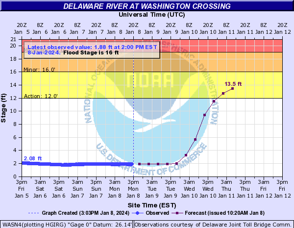
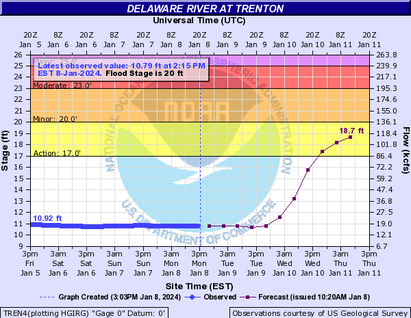
* ADDITIONAL DETAILS– Additional rainfall amounts between 1.0 to 3.0 inches are expected across the Watch area into Thursday. About two dozen of our river points are forecast to approach flood stage today into Thursday, with several exceeding flood stage. The rain will be heavy at times, with hourly rates reaching or exceeding an inch, with the more widespread and heaviest rain expected to fall this afternoon and early this evening. During the higher rainfall rates, local flash flooding cannot be ruled out. Excessive runoff may continue to cause rivers, creeks, and streams to rise through the end of the week even when the rain has ended.

Daily Forecast Wednesday April 3, 2024

Flood Watch in effect. April Showers are in full swing day 3 into the month!

Wednesday

Rain and possibly a thunderstorm before 11am, then rain between 11am and 2pm, then rain and possibly a thunderstorm after 2pm. Some of the storms could produce heavy rain. High near 48. Breezy, with an east wind 20 to 25 mph, with gusts as high as 35 mph. Chance of precipitation is 100%. New rainfall amounts between 1 and 2 inches possible.

Wednesday Night

Rain and possibly a thunderstorm, mainly before 5am, then a slight chance of rain and thunderstorms after 5am. Some of the storms could produce heavy rain. Low around 39. Breezy, with a northeast wind 10 to 20 mph becoming northwest after midnight. Chance of precipitation is 90%. New rainfall amounts between a half and three quarters of an inch possible.

Coastal Flood Advisory in effect until 2 PM today.

COASTAL FLOOD ADVISORY REMAINS IN EFFECT FROM 9 AM THIS
MORNING TO 2 PM EST THIS AFTERNOON...

* WHAT...Up to one foot of inundation above ground level
expected in low-lying areas near shorelines and tidal
waterways.

* WHERE...In New Jersey, Gloucester, Camden and Northwestern
Burlington. In Pennsylvania, Delaware, Philadelphia and Lower
Bucks.

* WHEN...From 9 AM this morning to 2 PM EST this afternoon.

* IMPACTS...At this level, flooding begins on the most
vulnerable roads along tidal waterways. Some partial or full
road closures are possible.

* ADDITIONAL DETAILS...Additional rounds of minor coastal
flooding are forecast around the times of the morning high
tide through at least the end of this week. Areas of minor
coastal flooding may occur with the morning high tides into
the weekend as well.

PRECAUTIONARY/PREPAREDNESS ACTIONS...

If travel is required, allow extra time as some roads may be
closed. Do not drive around barricades or through water of
unknown depth. Take the necessary actions to protect flood-prone
property.

Flooding Rain and Strong Winds Possible Tonight

Philadelphia, PA
loader-image
Philadelphia, US
3:19 pm, Apr 28, 2024
weather icon 78°F
L: 75° H: 82°
broken clouds
Pressure Pressure 1018 mb
Wind Wind 8 mph SW
Wind Gust Wind Gust 0 mph
Precipitation Precipitation 0 mm
Clouds Clouds 75%
Rain Chance Rain Chance 0%
Snow Snow 0
Sunrise Sunrise 6:03 am
Sunset Sunset 7:52 pm
DailyHourly
Daily ForecastHourly Forecast
Today 5:00 pm
weather icon
78° / 79°°F 0 mm 0% 10 mph 54 % 1018 mb 0 mm/h
Tomorrow 8:00 pm
weather icon
72° / 74°°F 0 mm 0% 5 mph 64 % 1017 mb 0 mm/h
Tomorrow 11:00 pm
weather icon
68° / 68°°F 0.35 mm 35% 6 mph 78 % 1017 mb 0 mm/h
Tomorrow 2:00 am
weather icon
65° / 65°°F 0 mm 0% 5 mph 84 % 1016 mb 0 mm/h
Tomorrow 5:00 am
weather icon
63° / 63°°F 0 mm 0% 4 mph 88 % 1016 mb 0 mm/h
Tomorrow 8:00 am
weather icon
67° / 67°°F 0 mm 0% 4 mph 77 % 1017 mb 0 mm/h
Tomorrow 11:00 am
weather icon
79° / 79°°F 0 mm 0% 4 mph 53 % 1017 mb 0 mm/h
Tomorrow 2:00 pm
weather icon
85° / 85°°F 0 mm 0% 6 mph 42 % 1016 mb 0 mm/h


This evening into early tomorrow morning the area will see a HEAVY RAIN, Strong Winds and FLOODING. After 7pm we will see rain move into the area. The area will see anywhere from 1-1.5″ of rain, After a week of heavy rain flooding is possible. We will see max wind gust around 45mph across the area, over 50mph at the shore.

Power outages are also possible as crews have worked hard since the Tuesday storms. Remember to NEVER drive across flooded roadways.

FLOOD WATCH in effect Friday Afternoon until Saturday Morning


FLOOD WATCH in effect .Flooding caused by excessive rainfall is possible.

* WHEN…From Friday evening through Saturday morning. * IMPACTS…Excessive runoff may result in flooding of rivers, creeks, streams, and other low-lying and flood-prone locations. Flooding may occur in poor drainage and urban areas. Area creeks and streams are running high and could flood with more heavy rain.

* ADDITIONAL DETAILS… – Rainfall totals ranging from 0.5-1.5 inches is forecast across the watch area. Given saturated soils and stream and river levels remaining high, additional flooding is possible in urban areas, creeks, and rivers. – http://www.weather.gov/safety/flood

PRECAUTIONARY/PREPAREDNESS ACTIONS… You should monitor later forecasts and be alert for possible Flood Warnings. Those living in areas prone to flooding should be prepared to take action should flooding develop.

Coastal Flood WATCH issued for SATURDAY 12am – 7pm

COASTAL FLOOD WATCH REMAINS IN EFFECT FROM LATE FRIDAY NIGHT THROUGH SATURDAY EVENING…

* WHAT…For the Coastal Flood Advisory, up to one half foot of inundation above ground level expected in low-lying areas near shorelines and tidal waterways. For the Coastal Flood Watch, one to two feet of inundation above ground level possible in low- lying areas near shorelines and tidal waterways.

* WHERE…In New Jersey, Gloucester, Camden and Northwestern Burlington. In Pennsylvania, Delaware, Philadelphia and Lower Bucks.

* WHEN…For the Coastal Flood Advisory, until 4 PM EST this afternoon. For the Coastal Flood Watch, from late Friday night through Saturday evening.

* IMPACTS…At this level, widespread roadway flooding occurs along tidal waterways. Some roads become impassable. Minor damage to vulnerable structures may begin to occur.

* ADDITIONAL DETAILS…Minor flooding is forecast to occur with this afternoon`s high tide. Strong southerly winds are forecast to increase again Friday night, which may lead to another round of moderate coastal flooding impacts along the tidal Delaware River beginning with the overnight high tide Friday night. Due to additional fresh water runoff, moderate flooding may persist through the Saturday afternoon high tide as well.

PRECAUTIONARY/PREPAREDNESS ACTIONS… If travel is required, allow extra time as some roads may be closed. Do not drive around barricades or through water of unknown depth. Take the necessary actions to protect flood-prone property.

STORM ALERT: Heavy Rain, Flash Flooding and Power Outages Possible

A powerful storm will be 2-3″ upwards of 4″ to the area starting early afternoon on Tuesday into Wednesday. The Philadelphia area will see 40-50 mph winds with gust to 60 mph. Shore points could see wind gust over 65 mph. This storm will cause localized flooding. Expect power outages.

The following are the projected RIVER FLOOD STAGE for The Delaware at Washington Crossing, Trenton and Burlington.

Flood Stage

Watches and Warnings:
WIND ADVISORY:

WIND ADVISORY IN EFFECT FROM 5 PM TUESDAY TO 3 AM EST WEDNESDAY.

WHEN…From 5 PM Tuesday to 3 AM EST Wednesday.

IMPACTS…Gusty winds could blow around unsecured objects. Tree limbs could be blown down and a few power outages may result.

ADDITIONAL DETAILS…
Saturated ground after multiple rounds of heavy rainfall over the last month has made trees more vulnerable to becoming uprooted with strong winds.

PRECAUTIONARY/PREPAREDNESS ACTIONS...
Use extra caution when driving, especially if operating a high profile vehicle. Secure outdoor objects.


FLOOD WATCH IN EFFECT FROM TUESDAY AFTERNOON THROUGH WEDNESDAY AFTERNOON.
WHEN

From Tuesday afternoon through Wednesday afternoon.

IMPACTS
Excessive runoff may result in flooding of rivers, creeks, streams, and other low-lying and flood-prone locations. *

ADDITIONAL DETAILS –
Rainfall of 1 to 3 inches possible Tuesday through early Wednesday, with the heaviest rain falling Tuesday night. The ground remains very saturated following multiple rounds of heavy rainfall over the last month. A period of higher hourly rainfall rates is possible during Tuesday night which would enhance the potential for flooding, particularly in the urban areas. Tidal inundation combined with runoff in coastal areas may significantly elevate the flood risk, especially if occurring during times of high tide.

COASTAL FLOOD WATCH IN EFFECT FROM TUESDAY EVENING THROUGH LATE TUESDAY NIGHT…

WHERE...
In New Jersey, Mercer, Gloucester, Camden and Northwestern Burlington. In Pennsylvania, Delaware, Philadelphia and Lower Bucks. * WHEN…From Tuesday evening through late Tuesday night.

IMPACTS…
At this level, widespread roadway flooding occurs along tidal waterways. Some roads become impassable. Minor damage to vulnerable structures may begin to occur.

ADDITIONAL DETAILS.
Tidal flooding could be significantly enhanced by an influx of fresh water runoff due to heavy rain Tuesday night.

PRECAUTIONARY/PREPAREDNESS ACTIONS…
If travel is required, allow extra time as some roads may be closed. Do not drive around barricades or through water of unknown depth. Take the necessary actions to protect flood-prone property

Flood Watch In Effect until 6pm Monday

FLOOD WATCH REMAINS IN EFFECT FROM THIS EVENING THROUGH MONDAY AFTERNOON… * WHAT…Flooding caused by excessive rainfall continues to be possible.

* WHERE..
.Portions of Delaware, including the following areas, Delaware Beaches, Inland Sussex, Kent, and New Castle. Portions of northeast Maryland, including the following areas, Caroline, Kent MD, Queen Annes, and Talbot. Portions of New Jersey, including the following areas, Atlantic, Atlantic Coastal Cape May, Camden, Cape May, Coastal Atlantic, Coastal Ocean, Cumberland, Eastern Monmouth, Gloucester, Hunterdon, Mercer, Middlesex, Morris, Northwestern Burlington, Ocean, Salem, Somerset, Southeastern Burlington, Sussex, Warren, and Western Monmouth. Portions of Pennsylvania, including the following areas, Berks, Carbon, Delaware, Eastern Chester, Eastern Montgomery, Lehigh, Lower Bucks, Monroe, Northampton, Philadelphia, Upper Bucks, Western Chester, and Western Montgomery. * WHEN…From this evening through Monday afternoon.

* IMPACTS…
Excessive runoff may result in flooding of rivers, creeks, streams, and other low-lying and flood-prone locations. Flooding may occur in poor drainage and urban areas.

* ADDITIONAL DETAILS…
– Rainfall totals of 2.0 to 3.0 inches are forecast across the watch area today and Monday, with the heaviest falling later tonight through early Monday morning. Locally higher amounts are probable. The ground is more saturated due to heavier rain over the last couple of weeks. A period of higher hourly rainfall rates are expected later tonight into early Monday morning, and this can locally enhance the flooding especially in urban areas

PRECAUTIONARY/PREPAREDNESS ACTIONS
You should monitor later forecasts and be alert for possible Flood Warnings. Those living in areas prone to flooding should be prepared to take action should flooding develop.

ALERT: Flood Watch In Effect From 2am Wednesday until Wednesday Afternoon

FLOOD WATCH IN EFFECT FROM 2 AM EDT WEDNESDAY THROUGH WEDNESDAY AFTERNOON

* WHAT…Flooding caused by excessive rainfall is possible. * WHERE…Portions of northern Delaware…New Jersey…and Pennsylvania…including the following areas…in northern Delaware…New Castle. In New Jersey…Camden, Coastal Ocean, Eastern Monmouth, Gloucester, Hunterdon, Mercer, Middlesex, Morris, Northwestern Burlington, Ocean, Salem, Somerset, Southeastern Burlington, Sussex, Warren, and Western Monmouth. In Pennsylvania…Berks, Carbon, Delaware, Eastern Chester, Eastern Montgomery, Lehigh, Lower Bucks, Monroe, Northampton, Philadelphia, Upper Bucks, Western Chester, and Western Montgomery.

* WHEN…From 2 AM EDT Wednesday through Wednesday afternoon. * IMPACTS…Excessive runoff may result in flooding of rivers, creeks, streams, and other low-lying and flood-prone locations.

* ADDITIONAL DETAILS… – Showers and thunderstorms with locally heavy rain are expected to cross the region late tonight through Wednesday. Rainfall rates may exceed 1-2 inches per hours, which may result in flash flooding.

PRECAUTIONARY/PREPAREDNESS ACTIONS… You should monitor later forecasts and be alert for possible Flood Warnings. Those living in areas prone to flooding should be prepared to take action should flooding develop.