Daily Forecast

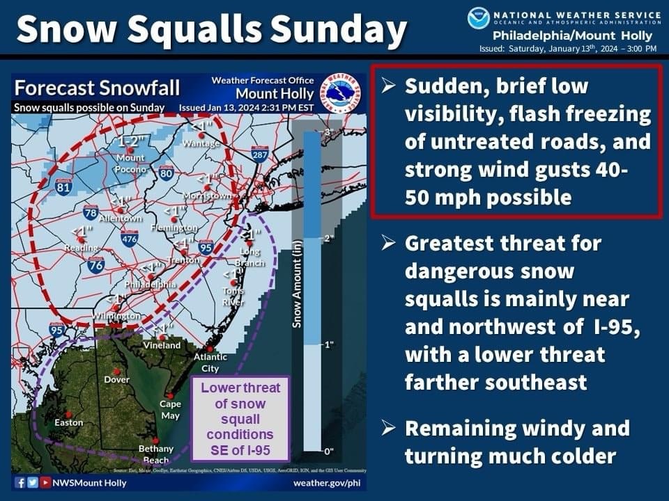
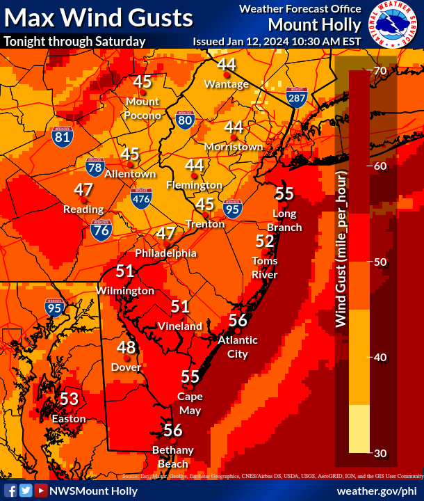
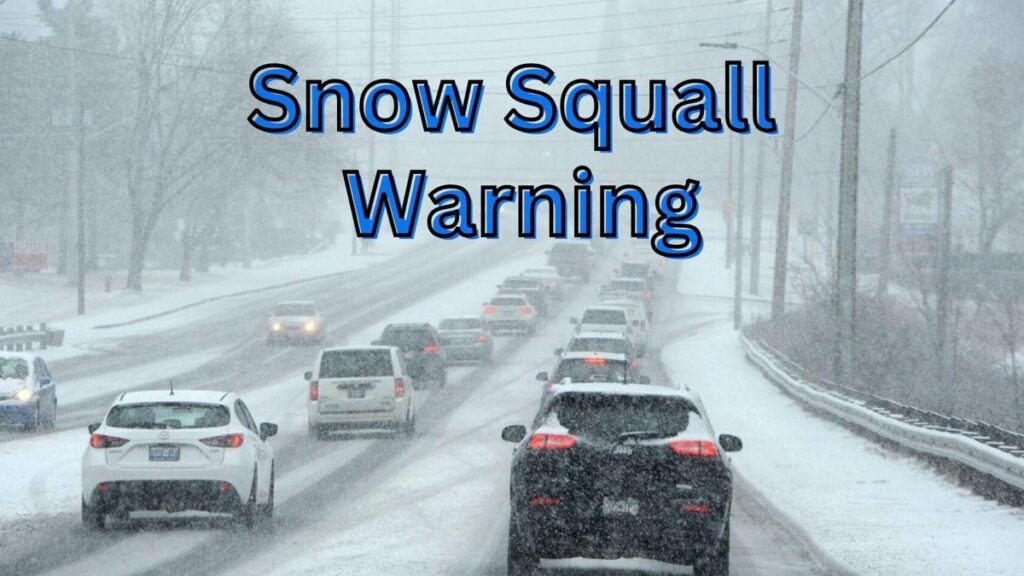
ALERT: SNOW SQUALL WARNING IN EFFECT USE CAUTION

The National Weather Service in Mount Holly NJ has issued a

  • Snow Squall Warning for…
    Central Hunterdon County in northwestern New Jersey…
    Southwestern Warren County in northwestern New Jersey…
    Southeastern Berks County in eastern Pennsylvania…
    Southeastern Lehigh County in eastern Pennsylvania…
    Northwestern Montgomery County in southeastern Pennsylvania…
    Northwestern Bucks County in southeastern Pennsylvania…
    Northeastern Chester County in southeastern Pennsylvania…
    Southeastern Northampton County in eastern Pennsylvania…
  • Until 1145 AM EST.
  • At 1107 AM EST, a dangerous snow squall was located along a line
    extending from Milford to near Elverson, moving east at 70 mph. HAZARD…Intense bursts of heavy snow and gusty winds leading to
    blowing snow and rapidly falling visibility. Wind gusts
    greater than 35 mph. SOURCE…Radar and webcams. IMPACT…Travel will become difficult and potentially dangerous
    within minutes.

This includes the following highways…
Pennsylvania Turnpike between mile markers 296 and 317.
Northeast Extension between mile markers 26 and 52.
Interstate 78 in Pennsylvania between mile markers 59 and 76.
Interstate 78 in New Jersey between mile markers 0 and 13.
Interstate 176 in Pennsylvania between mile markers 1 and 8.

Locations impacted include…
Allentown, Easton, Bethlehem, Pottstown, Phoenixville, Lansdale,
Forks, East Norriton, Coatesville, Emmaus, Quakertown, Perkasie,
Doylestown, Byram, Wilson, Downingtown, Souderton, Bedminster,
Hellertown, and Birdsboro.

PRECAUTIONARY/PREPAREDNESS ACTIONS…

Slow Down! Rapid changes in visibility and road conditions are
expected with this dangerous snow squall. Be alert for sudden
whiteout conditions.

Consider avoiding or delaying travel until the snow squall passes
your location. If you must travel, use extra caution and allow extra
time. Rapid changes in visibility and slick road conditions may lead
to accidents.

Monday night into Tuesday Winter Storm


The cold air is finally in place and we will have a small snow storm bring 2-4” across most of the area.

With this storm we will see temps 20s. This will be a light snow. Easy to shovel. I am not doing a snow map as this will be a 2-4” across most of the area except the shore points. Some areas could see higher snowfall amounts depending if banding sets up.

Dangerous Snow Squalls This Morning.

DANGEROUS SNOW SQUALLS TO IMPACT THE REGION LATE THIS MORNING
INTO THE AFTERNOON HOURS...

One or more bands of snow squalls will be moving east at 50 to 55
mph along the leading edge of an arctic airmass, with the
potential to impact portions of eastern Pennsylvania and adjacent
areas of New Jersey and northern Delaware.

Near whiteout conditions and a quick one half inch of snow in just
10 to 15 minutes will lead to dangerous travel conditions as a
result of the very poor visibility and snow or ice covered roads.
Winds will gust up to 50 mph in the squalls.

If possible, delay any travel until the mid to late afternoon
hours. If you are traveling, your recognition of these squalls
and the actions you take to get off the road or help to gradually
slow traffic could prevent a high speed, multi-vehicle accident
and save your life and the lives of others.

If you see terrain features and objects off in the distance being
obscured by heavy snow within the dangerous snow squalls, take
quick action to pull off the road to a safe location, such as a
parking lot or driveway to wait out the squall.

If you are on an interstate, it`s best to get off the road at the
nearest exit as soon as you notice the squall to ensure the
safety of you and your passengers. If there isn`t an opportunity
to safely exit the interstate, slow down gradually, well before
entering the squall and turn on your flashing hazard lights.

COLD and Snowy for Wild Card Weekend

[location-weather id=”4448″]

Tonights playoff game between the Kansas City Chiefs and Miami Dolphins will be played in dangerously cold conditions and the National Weather Service is asking fans to take precautions.

‘Cover all extremities including your head and face,’ read the warning from the NWS.

Temperatures are expected to be below zero with a -23 wind chill for kickoff at Arrowhead Stadium. During the game wind gusts potentially will hit 30mph and cause a -30º wind chill. This would make it the coldest game ever played in NFL history.

PITT VS BUFFALO
Heavy snow possible during the game tomorrow at 1pm.

Flooding Rain and Strong Winds Possible Tonight

[location-weather id=”4428″]


This evening into early tomorrow morning the area will see a HEAVY RAIN, Strong Winds and FLOODING. After 7pm we will see rain move into the area. The area will see anywhere from 1-1.5″ of rain, After a week of heavy rain flooding is possible. We will see max wind gust around 45mph across the area, over 50mph at the shore.

Power outages are also possible as crews have worked hard since the Tuesday storms. Remember to NEVER drive across flooded roadways.

Weekend Forecast Jan. 13 and 14, 2024

We have flood warnings and watches in effect until 5pm tonight. We are tracking snow for early in the week. Stay turned over the weekend for details on it.

Saturday

A chance of rain, mainly before noon. Mostly cloudy, then gradually becoming sunny, with a temperature falling to around 43 by 5pm. Breezy, with a west wind 15 to 25 mph, with gusts as high as 45 mph. Chance of precipitation is 30%. New precipitation amounts between a tenth and quarter of an inch possible.

Saturday Night

Mostly clear, with a low around 30. Breezy, with a southwest wind 15 to 20 mph, with gusts as high as 35 mph.

Sunday

A chance of snow after 5pm. Mostly sunny, with a high near 40. Southwest wind 10 to 15 mph, with gusts as high as 25 mph. Chance of precipitation is 30%. Little or no snow accumulation expected.

Sunday Night

A chance of snow before 8pm. Mostly clear, with a low around 19. Chance of precipitation is 30%.

FLOOD WATCH in effect Friday Afternoon until Saturday Morning


FLOOD WATCH in effect .Flooding caused by excessive rainfall is possible.

* WHEN…From Friday evening through Saturday morning. * IMPACTS…Excessive runoff may result in flooding of rivers, creeks, streams, and other low-lying and flood-prone locations. Flooding may occur in poor drainage and urban areas. Area creeks and streams are running high and could flood with more heavy rain.

* ADDITIONAL DETAILS… – Rainfall totals ranging from 0.5-1.5 inches is forecast across the watch area. Given saturated soils and stream and river levels remaining high, additional flooding is possible in urban areas, creeks, and rivers. – http://www.weather.gov/safety/flood

PRECAUTIONARY/PREPAREDNESS ACTIONS… You should monitor later forecasts and be alert for possible Flood Warnings. Those living in areas prone to flooding should be prepared to take action should flooding develop.

Daily Forecast Friday Jan. 12, 2024

Have a GREAT Friday! Rain will move in this afternoon!

Friday

A chance of rain after 5pm. Increasing clouds, with a high near 44. Light and variable wind becoming southeast 5 to 10 mph in the afternoon.

Friday Night

Rain. Low around 42. Breezy, with an east wind 15 to 20 mph becoming south after midnight. Winds could gust as high as 35 mph.

Coastal Flood WATCH issued for SATURDAY 12am – 7pm

COASTAL FLOOD WATCH REMAINS IN EFFECT FROM LATE FRIDAY NIGHT THROUGH SATURDAY EVENING…

* WHAT…For the Coastal Flood Advisory, up to one half foot of inundation above ground level expected in low-lying areas near shorelines and tidal waterways. For the Coastal Flood Watch, one to two feet of inundation above ground level possible in low- lying areas near shorelines and tidal waterways.

* WHERE…In New Jersey, Gloucester, Camden and Northwestern Burlington. In Pennsylvania, Delaware, Philadelphia and Lower Bucks.

* WHEN…For the Coastal Flood Advisory, until 4 PM EST this afternoon. For the Coastal Flood Watch, from late Friday night through Saturday evening.

* IMPACTS…At this level, widespread roadway flooding occurs along tidal waterways. Some roads become impassable. Minor damage to vulnerable structures may begin to occur.

* ADDITIONAL DETAILS…Minor flooding is forecast to occur with this afternoon`s high tide. Strong southerly winds are forecast to increase again Friday night, which may lead to another round of moderate coastal flooding impacts along the tidal Delaware River beginning with the overnight high tide Friday night. Due to additional fresh water runoff, moderate flooding may persist through the Saturday afternoon high tide as well.

PRECAUTIONARY/PREPAREDNESS ACTIONS… If travel is required, allow extra time as some roads may be closed. Do not drive around barricades or through water of unknown depth. Take the necessary actions to protect flood-prone property.

Additional rain will move into the area on Friday. Snow Monday/Tuesday?????

[location-weather id=”4428″]

As we begin the clearing up from last nights storms. We are tracking not one but two additional storms on the horizon. The first will be Friday afternoon into Saturday we could see an inch or two of rain. Our eyes are glued to Monday/Tuesday timeframe.

While over the last few days a few of you have commented asking about next weeks storm potential. I have been keeping an eye on this for days but did not want to mention it due to the nature of the storms we saw yesterday. While we are still 5-6 days out. We are starting to track what could be a system that will bring snow and rain to parts of the area. At this time model guidance is hinting at possible snow for much of the area. While it is way too early to tell. I am just sharing this information with you as we are keeping a very close eye on it.