NASA Wallops May 8 Rocket Launch Visible in Eastern United States

Press Release issued by NASA:


A mission to explore energy transport in space using a NASA suborbital sounding rocket launching May 8, 2021, from NASA’s Wallops Flight Facility in Virginia may provide a brief light show for residents of the eastern United States and Bermuda.

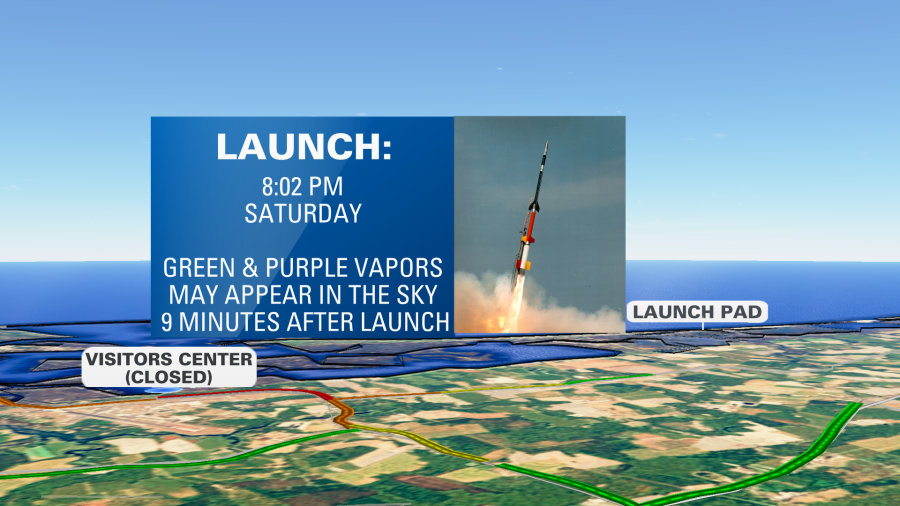
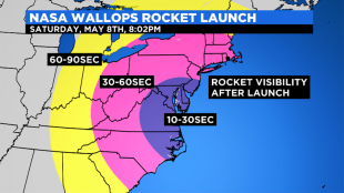
The mission is scheduled for no earlier than 8:02 p.m. EDT with a 40-minute launch window, Saturday, May 8. Backup launch days run through May 16. The launch may be visible, weather permitting, in much of the eastern United States from the Atlantic coast to the Mississippi River.

A four-stage Black Brant XII rocket will be used for the mission that includes the release of barium vapor that will form two green-violet clouds that may be visible for about 30 seconds. The barium vapor is not harmful to the environment or public health

The mission, called the KiNETic-scale energy and momentum transport eXperiment, or KiNet-X, is designed to study a very fundamental problem in space plasmas, namely, how are energy and momentum transported between different regions of space that are magnetically connected?  

The vapor will be released approximately 9 minutes and 30 seconds to around 10 minutes after launch at about 217-249 miles altitude over the Atlantic Ocean and 540-560 miles downrange from Wallops and just north of Bermuda.

Immediately after release of the vapor, the spherical clouds are a mixture of green and violet, but that phase only lasts about 30 seconds when the un-ionized component of the cloud has diffused away. After exposure to sunlight the vapor clouds quickly ionize and take on a violet color. 

The ionized portion of the cloud becomes tied to the magnetic field lines and diffuses parallel to the field lines but not perpendicular to it.  In the mid-Atlantic region latitudes, the field lines are inclined by about 45 degrees to the horizontal, so the violet clouds stretch out in a slanted orientation and look more like short trails than a cloud.  Because the motion of the neutral portion of the clouds is not constrained by the magnetic field lines, they spread out more quickly and become too thin to see with the naked eye much sooner than the ionized component.

In general, the human eye does not see violet colors very well in darkness. The KiNET-X clouds will therefore be more difficult for the casual observer to see than some of the previous vapor missions launched from Wallops.

Live coverage of the mission will be available on the Wallops IBM video site (previously Ustream) beginning at 7:40 p.m. on launch day. Launch status updates can be found on the Wallops Facebook and Twitter sites.

The NASA Visitor Center at Wallops will not be open for launch viewing.

Header image: KiNet-X Visibility Map.

Keith Koehler
NASA’s Wallops Flight Facility, Virginia
757-894-4152
keith.a.koehler@nasa.gov

High-Wind-Warning-Graphic-from-NWS

ALERT: HIGH WIND WARNING IN EFFECT 2pm Friday until 4am Saturday.

* WHAT...Northwest winds 25 to 35 mph with gusts up to 60 mph
  expected.

* WHERE...Most of New Jersey, portions of eastern Pennsylvania,
  Delaware, and portions of eastern Maryland.

* WHEN...From 2 PM Friday to 4 AM EDT Saturday.

* IMPACTS...Damaging winds will blow down trees and power lines.
  Widespread power outages are expected. Travel will be
  difficult, especially for high profile vehicles.

* ADDITIONAL DETAILS...The strongest wind gusts, of up to 60 mph,
  are most likely to occur from late Friday afternoon through the
  predawn hours Saturday.

PRECAUTIONARY/PREPAREDNESS ACTIONS...

People should avoid being outside in forested areas and around
trees and branches. Use caution if you must drive.

The Winter Weather Warning has been canceled, a Winter Weather Advisory is now in effect until 7pm Friday.

* WHAT...Mixed precipitation. Additional snow accumulations of 1
  to 3 inches and ice accumulations of around one tenth of an
  inch.

* WHERE...Portions of central, northern, northwest and southern
  New Jersey, southeast Pennsylvania and northern Delaware.

* WHEN...Until 7 PM EST Friday.

* IMPACTS...Expect slippery road conditions. The hazardous
  conditions will impact the commute times this evening and on
  Friday morning.

* ADDITIONAL DETAILS...Patchy freezing drizzle, sleet, and snow
  will continue through the evening hours. Snow, sleet, and rain
  will then increase Friday around sunrise from the southwest as
  the next system approaches.

PRECAUTIONARY/PREPAREDNESS ACTIONS...

Slow down and use caution while traveling.

The latest road conditions for the state you are calling from can
be obtained by calling 5 1 1.

A Winter Storm Watch has been issued for Late Wednesday night until Friday Afternoon

WINTER STORM WATCH IN EFFECT FROM LATE WEDNESDAY NIGHT THROUGH
FRIDAY AFTERNOON...

* WHAT...Heavy mixed precipitation possible. Total snow and sleet
  accumulations of 3 to 6 inches and ice accumulations of one
  tenth to one quarter of an inch possible.

* WHERE...Portions of central, northern and southern New Jersey,
  southeast Pennsylvania, northeast Maryland and northern
  Delaware.

* WHEN...From late Wednesday night through Friday afternoon.

* IMPACTS...Travel could be very difficult. The hazardous
  conditions could impact the morning or evening commute.

* ADDITIONAL DETAILS...Precipitation will begin as snow Thursday
  morning, with the heaviest snowfall expected Thursday morning
  into early Thursday afternoon. Sleet and/or freezing rain will
  then mix in Thursday evening into Thursday night. Light wintry
  precipitation may continue into the daytime hours on Friday.

PRECAUTIONARY/PREPAREDNESS ACTIONS...

Monitor the latest forecasts for updates on this situation.

but wait there’s MORE!

After some boring winters the past few years, This year is non-stop. We are tracking our next winter storm that will bring moderate snowfall to the area. While this storm does appear to start out as snow for everyone, we will see a changeover to an icy mix and even rain for some. How strong does the low get? That is yet to be determined. If the arctic air that will move in tonight is able to stay in place during this Thursday storm most of the area will see all snow with little changeover, but we need a few things to work out perfectly for that to happen. At this time it looks like a general 4-6″ is POSSIBLE across most of the region with 6″ + in the Lehigh Valley, as well as 1-3″ across Southern parts of NJ BEFORE a changeover to ICE/Rain. A lot of factors are in play but we will be tracking this storm and bring you the latest information as it progresses. Until then, enjoy the near 50º today and get ready for cold air to move in this morning.

A Winter Weather Advisory Is In Effect Until 5am Tuesday

WINTER WEATHER ADVISORY IS NOW EFFECT TO 5 AM EST TUESDAY...

* WHAT...Freezing rain expected. Total ice accumulations of
  around one tenth of an inch.

* WHERE...Portions of central and northern New Jersey and
  southeast Pennsylvania.

* WHEN...From 1 PM this afternoon to 5 AM EST Tuesday.

* IMPACTS...Difficult travel conditions are possible. The
  hazardous conditions could impact the evening commute.

PRECAUTIONARY/PREPAREDNESS ACTIONS...

Slow down and use caution while traveling. Prepare for possible
power outages.

The latest road conditions for the state you are calling from can
be obtained by calling 5 1 1.

STAY OFF THE ROADS IF POSSIBLE. 

Winter Weather Advisory will go into effect 1pm Monday until 5am Tuesday for Freezing Rain

WINTER WEATHER ADVISORY IN EFFECT FROM 1 PM MONDAY TO 5 AM EST
TUESDAY...

* WHAT...Freezing rain expected. Total ice accumulations of one
  tenth to two tenths of an inch.

* WHERE...Portions of central New Jersey and southeast
  Pennsylvania.

* WHEN...From 1 PM Monday to 5 AM EST Tuesday.

* IMPACTS...Difficult travel conditions are possible. The
  hazardous conditions could impact the morning commute on
  Tuesday.

PRECAUTIONARY/PREPAREDNESS ACTIONS...

Slow down and use caution while traveling. Prepare for possible
power outages.

The latest road conditions for the state you are calling from can
be obtained by calling 5 1 1.

The Winter Weather Advisory is now in effect until 10am Sunday

WINTER WEATHER ADVISORY NOW IN EFFECT FROM 1 PM THIS AFTERNOON
TO 10 AM EST SUNDAY...

* WHAT...Mixed precipitation expected. Total snow accumulations of
  less than one inch and ice accumulations of around one tenth of
  an inch.

* WHERE...Portions of central, northern, northwest and southern
  New Jersey and southeast Pennsylvania.

* WHEN...From 1 PM this afternoon to 10 AM EST Sunday.

* IMPACTS...Difficult travel conditions are possible due to icy
  roadways, especially Saturday afternoon through Saturday night.

PRECAUTIONARY/PREPAREDNESS ACTIONS...

Slow down and use caution while traveling.

A wintry mix will move into the region this morning. Within the advisory area, expect a change to freezing rain this afternoon continuing into tonight. Precipitation is expected to taper off late tonight into early Sunday morning 

This is the first of several systems which will affect the region with potential wintry precipitation into the new week. The main periods we are concerned about are Monday night into Tuesday and again Wednesday night through Friday