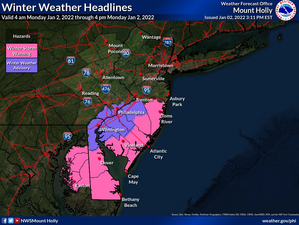
Winter Storm Warning and Advisories Posted

A winter storm that was just going to bring some snow showers to the area has been moving trending north on the latest model runs. At this time the NWS has issued a Winter Storm Warning for South NJ and Delaware. A Winter Weather Advisory for Philly south and east.


While the ground is very warm the snow will start very heavy towards the beginning of the storm and it will help cool the surface down. Monday morning commute will be a mess, it might be good to stay home if you are in areas under the Winter Storm Warning.

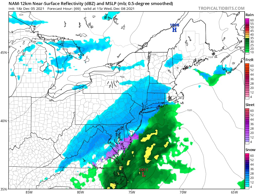
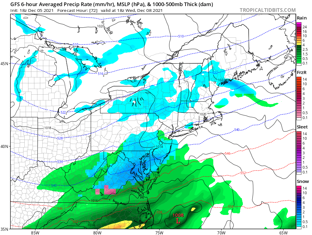
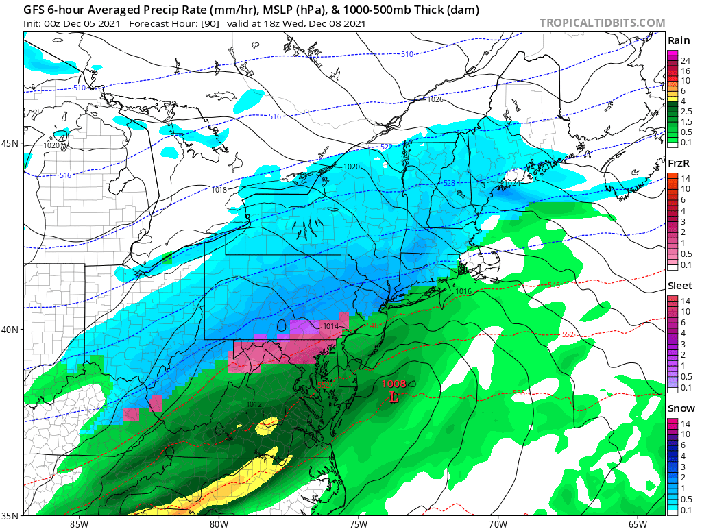
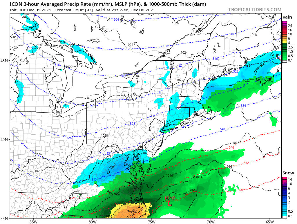
The latest 12z GFS model and 12z Euro.
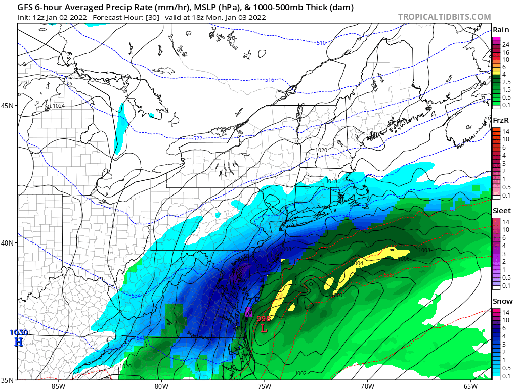
The latest GFS 12z run. As you can see the storm is a bit north then the 6z.


TIMING:
The snow will move in into South NJ around 2/3am and we can see snow in the Philly Metro area around 4/5am. Once the snow starts it will become heavy at times. We will see the snow move out in the afternoon West to East.
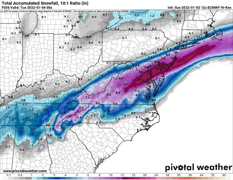
SNOWFALL TOTALS:
The further north you are the less snow you will see.

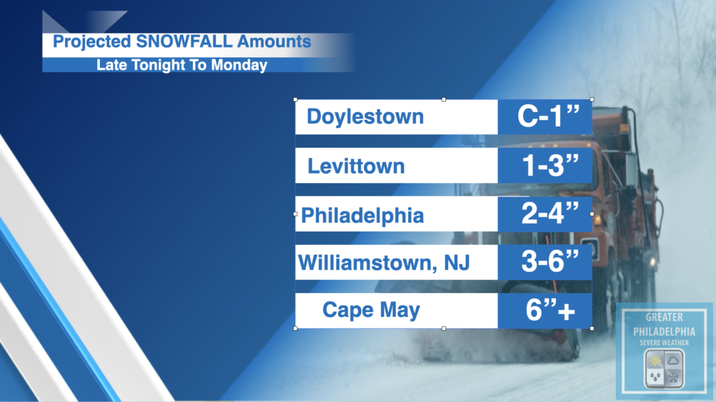
You will see SHARP cutoffs to the north. In Bucks County anything NORTH of i295 in Yardley will see less snow than Fairless Hills/Bristol/Bensalem will see. These numbers could change depending on where bands set up. We will have an update call if needed later this evening.
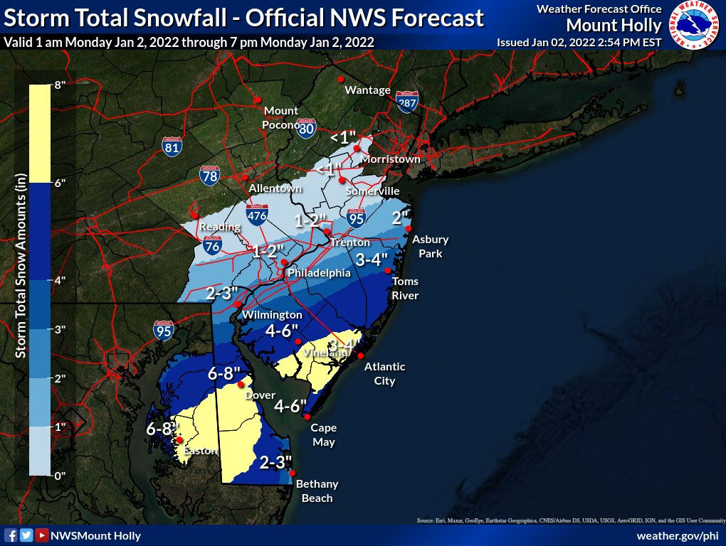


Here is the NWS map

The snow totals above could be locally higher depending on where the heavy banding sets up.

School Closing Projections:
We will post any school closing information here : https://greaterphilaseverewx.com/school-closings/


Warm Saturday To Bring Storms and Wind Advisory

While we will be close to hitting 70s on Saturday, the area will see wind gust up to 45mph through the late evening. This has prompted the NWS to issue a Wind Advisory from 1pm Saturday until 1am Sunday. A line of showers will move across the area durning the evening that will bring the potential for damaging winds and a tornado can’t be ruled out.


WIND ADVISORY IN EFFECT FROM 1 PM SATURDAY TO 1 AM EST
SUNDAY

* WHAT...South winds 15 to 25 mph with gusts up to 45 mph
  expected. Winds will abruptly shift northwest behind a cold
  front Saturday evening.

* WHERE...Portions of central, northern and southern New Jersey
  and east central and southeast Pennsylvania.

* WHEN...From 1 PM Saturday to 1 AM EST Sunday.

* IMPACTS...Gusty winds could blow around unsecured objects.
  Tree limbs could be blown down and a few power outages may
  result.

* ADDITIONAL DETAILS...Secure any outdoor holiday decorations from
  blowing away in the wind.

PRECAUTIONARY/PREPAREDNESS ACTIONS...

Use extra caution when driving, especially if operating a high
profile vehicle. Secure outdoor objects.

Wednesday Snow, Record Temps and White Christmas???

As everyone has been waiting for the final calls on our mid week sNOw storm. Our final call is a Dusting to half inch for everyone. The storm is trending further south which result in not much snow. Just be alert for wet and slippery conditions.


A big warming trend sets up for the next couple of weeks which will result in our area seeing above normal temps. This coming weekend an airmass will overspread the area on Saturday. We will see record high temps some locations may see temps into the 70s!!!!


Now we are 18 days until Christmas at this point I do not see any major signs for a White Christmas so at this point I think it is safe to say it will NOT be a White Christmas.

Mid Week Winter Storm To Bring Light Snow To The Area

DEC. 7th UPDATE:

At this time our final call is a C-1″ for most of the area. Most of the snow will melt on contact but grassy surfaces could see a coating. NO accumulations with this one.


The first winter storm of the year is less than 48 hours away. While this will not bring significant snowfall to the area, the first snowfall always poses challenges with roads and driving. Most of the area will see a COATING to 2″ (most areas will be closer to a coating to 0.5″


Again most of the area will see a coating to 2″ of snow. Most of the snow will move into the area late morning on Wednesday into the early afternoon before moving out of the area by the evening rush. While most accumulations will be on grassy surfaces a slush mess on the roads is possible. While there is a lot of time between now and the storm if we need to adjust any information tomorrow we will.

WINTER DRIVING TIPS FROM PENNDOT!
Remember, if winter weather is forecast, eliminate all unnecessary travel. This will keep you and your family safe and allow PennDOT to more easily perform its winter duties. However, if you must travel, PennDOT offers the following tips for safe driving this winter season

High Winds This Afternoon

As you can feel we have a GREAT Weather day but it won’t last long. While temps are in the 60s across most of the area. We will see a cold front move across the area late afternoon. When this front moves across the area wind gust 40-50 mph are possible. By late tonight temps will be in the upper 30s/low 40s.

As of this time the Wednesday systems looks to bring light snow to most of the area C-2” is very possible but a more official forecast will come later.

Until then enjoy this great weather.

Mid Week Storm Update

The low pressure system that will pass by on Wednesday could bring a few inches of snow to parts of the area highest chance right now is to our south. While at this time things are still very uncertain on how much precip will fall. Take everything with a grain of salt.

The latest model trends have began to keep the low to our southeast which would favor any precipitation to be mostly snow, tho along the coast it could be a rain/snow mix. BUT if this continues to trend to the southeast then most of the precip will be over the ocean and not much over land. The third option is that it moves further northwest resulting in a rain/snow mix for most of us. As you will see below we have two snapshots of two models around the same time, two completely different forecast.

At this point it appears most of this will fall during the day on Wednesday. The big concern would be the wet driving conditions on Wednesday morning. While it is unclear how much snow will fall but if I had to guess right now a general 1-2″ is possible. We will be following the trends overnight and have more on this post updated as models run.

18z Models

The 18z Nam at 69hrs shows snow over most of the area.
The 18z GFS at 72 hrs shows light snow/mix over parts of the area. But we can see the main system to the south.

All Eyes On Mid-Week Storm Threat…..

A low pressure system could bring some winter weather to parts of the Northeast late Tuesday night into Wednesday. While at this point the track is highly uncertain but the threat of winter weather is possible. How much and what type of precipitation is too early to tell at this point but some signs are starting to develop.

If this system tracks to our southeast we might not see much warm air in which case could bring more snow to the area. If the storm tracks over the closer to our region it will bring in warmer air resulting in rain for most of the area. A third option is the track takes the storm further off the coast which would keep most of the precipitation off shore.

The timing in which the precipitation will fall also places a huge factor. If it is a majority falls in the daytime hours we will see more potentially more rain. However if the storm moves into the area in the overnight hours some would potentially see more snow/mix. At this time please take this with a grain of salt.

We are going to be keeping a very close eye on this developing storm and will bring you the latest updates as models run.

The 0zGFS run is showing the Rain/Snow Mix line very close to i95 corridor. While a lot of things can happen between now and Wed. We are going to keep a close eye on this storm and bring you the latest tomorrow afternoon after the 12z runs.

As you can see the 00z GFS shows the Rain/Snow line close to the area. Again this is not a forecast from GPSW we are just sharing what the models are showing at this point.
Here is another model that is around the same time period but shows a different outcome.

Snowy Sunday Night for Mount Pocono

This afternoon as a cold front pushes across the area parts of the area will see strong to severe gusty thunderstorms. The biggest threat area will be in Eastern NJ. Timing is from around noon until 4pm. As the storms roll through you will feel a big difference as we head into this evening as temps will take a dive. Wind gust will be 40-50mph are possible, even small hail. While not everyone will see severe storms the threat is possible for many.


FLOOD WATCH WATCH in effect until late Saturday night

.
The Flash Flood Watch continues for

* Portions of northern Delaware...New Jersey...and Pennsylvania...
  including the following areas...in northern Delaware...New Castle.
  In New Jersey...Atlantic, Camden, Coastal Ocean, Cumberland,
  Eastern Monmouth, Gloucester, Hunterdon, Mercer, Middlesex,
  Morris, Northwestern Burlington, Ocean, Salem, Somerset,
  Southeastern Burlington, Warren, and Western Monmouth. In
  Pennsylvania...Berks, Delaware, Eastern Chester, Eastern
  Montgomery, Lehigh, Lower Bucks, Northampton, Philadelphia, Upper
  Bucks, Western Chester, and Western Montgomery.

* From 2 PM EDT this afternoon through late Saturday night.

* A slow-moving weather system will affect the region today and
  Saturday.  Thunderstorms are likely to develop this afternoon and
  evening, with additional storms possible tonight through much of
  Saturday. With hot and humid conditions in advance of this system,
  storms will likely produce torrential downpours. As storms are
  also expected to be slow-moving, there is elevated potential for
  localized flash flooding, especially in more vulnerable urban
  areas and in locations that received substantial rainfall during
  the past couple of weeks.

PRECAUTIONARY/PREPAREDNESS ACTIONS...

You should monitor later forecasts and be prepared to take action
should Flash Flood Warnings be issued.