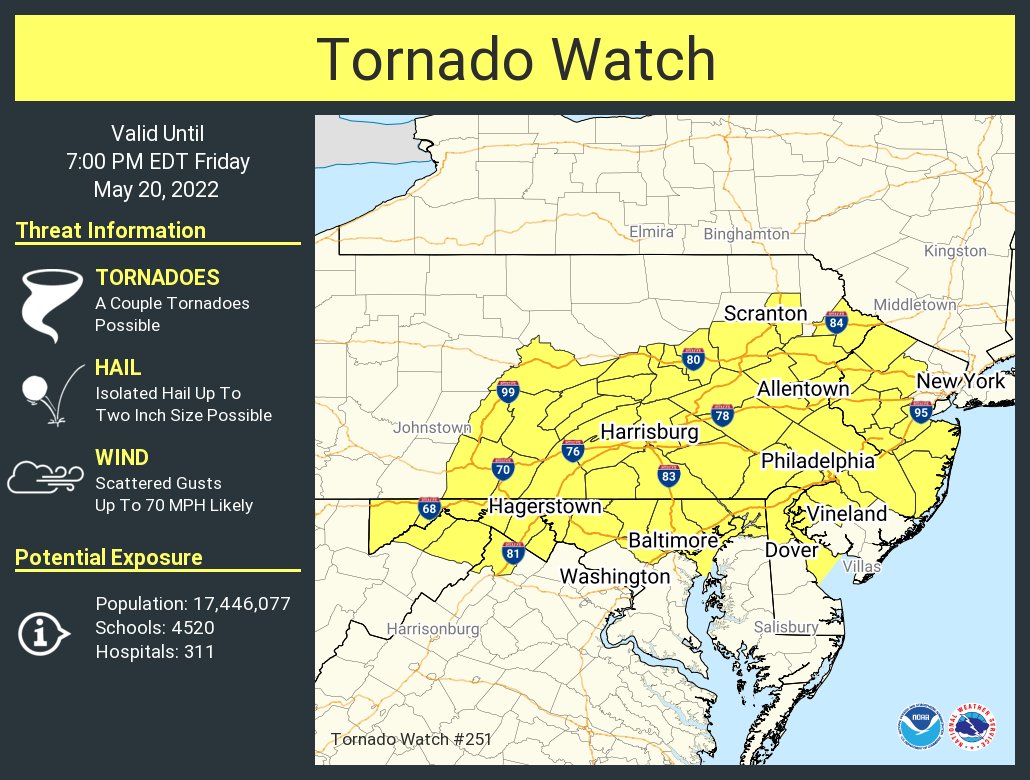
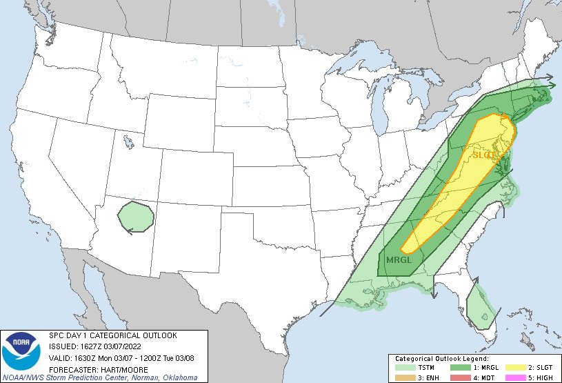
This afternoon confidence has increased for the potential for severe weather into this evening. Most of the area from i-95 northwest is now in a SLIGHT risk. The key factors today will be damaging winds, hail and tornados are also possible.
The NWS has issued a TORNADO WATCH for the entire area until 7pm.
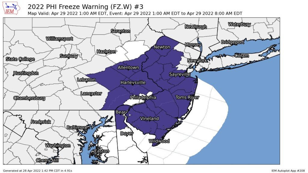
A Freeze Warning Has Been Issued until 8am. Protect any plants that you might have outside if you live within the freeze warning.
FREEZE WARNING IN EFFECT FROM 1 AM TO 8 AM EDT FRIDAY...

* WHAT...Low temperatures between 30 and 32 degrees expected.

* WHERE...Much of New Jersey, southeast Pennsylvania and northern
  Delaware.

* WHEN...From 1 AM to 8 AM EDT Friday.

* IMPACTS...Frost and freeze conditions will kill crops and
  other sensitive vegetation.

* ADDITIONAL DETAILS...If winds do not diminish overnight, some
  areas may not get below freezing.

PRECAUTIONARY/PREPAREDNESS ACTIONS...

Take steps now to protect tender plants from the cold
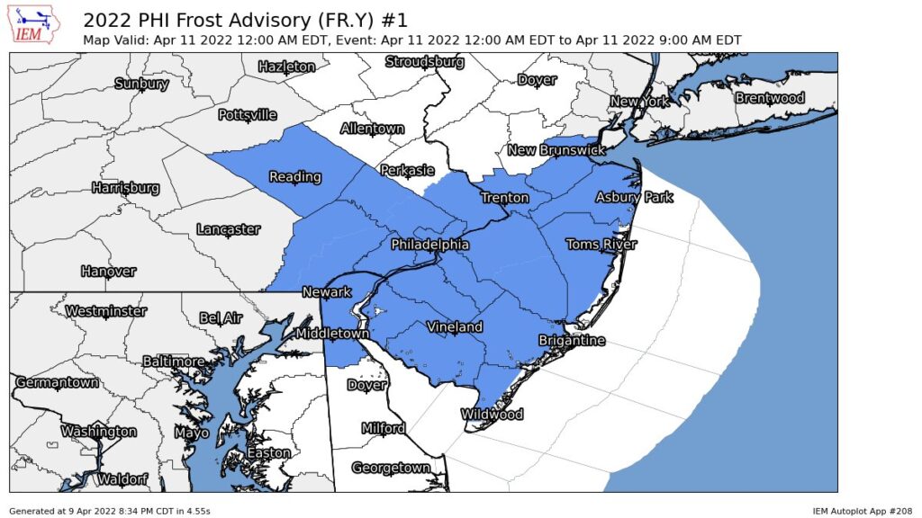
FROST ADVISORY IN EFFECT FROM SUNDAY NIGHT TO 9 AM
EDT MONDAY...

* WHAT...Minimum temperatures ranging from 33 to 36 degrees will
  result in frost formation.

* WHERE...Portions of central, northern and southern New Jersey,
  east central and southeast Pennsylvania and northern Delaware.

* WHEN...From midnight Sunday night to 9 AM EDT Monday.

* IMPACTS...Frost could kill sensitive outdoor vegetation if left
  uncovered.

PRECAUTIONARY/PREPAREDNESS ACTIONS...

Take steps now to protect tender plants from the cold.
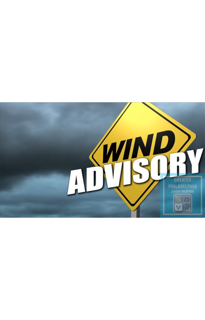
WIND ADVISORY REMAINS IN EFFECT UNTIL 1 AM EST SUNDAY...

* WHAT...Northwest winds 15 to 25 mph with gusts up to 50 mph
  expected.

* WHERE...Portions New Jersey, southeast Pennsylvania, the eastern
  shores of Maryland, and Delaware.

* WHEN...Until 1 AM EST Sunday.

* IMPACTS...Gusty winds could blow around unsecured objects.
  Tree limbs could be blown down and a few power outages may
  result.

* ADDITIONAL DETAILS...Strong winds develop late this morning
  morning and continue into the afternoon. There may be a lull
  this evening before winds increase once again.

PRECAUTIONARY/PREPAREDNESS ACTIONS...

Use extra caution when driving, especially if operating a high
profile vehicle. Secure outdoor objects.
Please post current observations as you see them. This is a fast moving system that will bring 1-2″/hr snowfall rates. This afternoon we will see temps dropping fast. Use caution if driving after the snow stops as most surfaces will freeze.
The SPC has placed the area in a SLIGHT chance of severe weather for this afternoon and evening. We will see a line of storms develop with some thunderstorms. These storms will be capable of producing wind guts up to 60 mph.
WIND ADVISORY IN EFFECT FROM NOON TODAY TO 1 AM EST TUESDAY...

* WHAT...Southwest winds 20 to 30 mph with gusts of 40 to 50 mph
  expected shifting to northwest this evening with gusts of 40 to
  50 mph.

* WHERE...Portions of central, northern, northwest and southern
  New Jersey, east central, northeast and southeast
  Pennsylvania, northeast Maryland and central, northern and
  southern Delaware.

* WHEN...From noon today to 1 AM EST Tuesday.

* IMPACTS...Gusty winds could blow around unsecured objects.
  Tree limbs could be blown down and a few power outages may
  result.

* ADDITIONAL DETAILS...A line of showers with a few embedded
  thunderstorms will move across the area late this afternoon into
  this evening along a cold front and could contain winds briefly
  gusting up to 60 mph in places.


Our team will bring you the latest info as these storms move across the area this afternoon and evening.
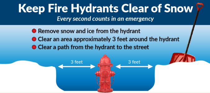
When shoveling a fire hydrant it is important to shovel not only the access to the hydrant from the roadway, but also 3-feet around the fire hydrant. Remember the “3 rules for 3 feet”:
1.) Access: When arriving at a hydrant, the “hydrant fire fighter” grabs the hydrant bag with all of the hydrant tools and adapters, and the large diameter supply hose that will get the water to the fire truck. The fire fighter must pull the supply hose for the back of the truck and will “wrap the hydrant” until the truck drives off. This keeps the supply hose anchored at the hydrant and keeps hose from getting drug down the roadway behind the pumper as it drives away.
2.) Room to Work: When affixing adapters, and “charging the hydrant” or turning on the hydrant, adapters and wrenches have a tendency to fall victim to gravity. This problem can be compounded by these items getting lost in the snow. Three feet is vital to quickly find a dropped piece of hardware.
3.) Safety: Some may ask, “Why do I need to shovel the back of the hydrant?” “They can get to the front of the hydrant.” When “charging the hydrant” or turning on the hydrant, for safety reason, the fire fighter MUST stand behind the hydrant. They will NEVER stand in front of the hydrant or to the side of the hydrant. If a hydrant cap, coupling or adapter were to not be securely affixed or become damaged, the water pressure could blow the cap, coupling or adapter off, causing injury to the fire fighter. Once again, having all sides (front, right, left and BACK) is vital for proper and safe hydrant operations.
If you have a hydrant on your property, we ask that you shovel your hydrant to help your local fire department. If you are unable to shovel your hydrant due to health reasons, etc., attempt to educate your neighbors about this “Adopt a Hydrant” program and ask them for assistance. If you have a neighbor who is elderly, or who otherwise can not shovel a fire hydrant, please offer to help shovel the hydrant on their property. In any event, we would like to stress, please seek permission to access another’s property.
A Winter Weather Advisory is now in effect. We will see SNOW over take the area the next few hours before changing over to a wintery mix then all rain. We will have very gusty winds this evening/overnight which will lead to power outages. Most areas will see 1-2" of snow before changing over to the mix to rain. Higher amounts north of the city.  Some areas might see more snow as an over performer for some.

The Winter Weather Advisory is in effect until 1am for parts of Northern Bucks County until 1am.


WINTER WEATHER ADVISORY REMAINS IN EFFECT UNTIL 10 PM EST THIS
EVENING...

* WHAT...Mixed precipitation expected. Total snow accumulations
  of up to one inch and ice accumulations of a light glaze.
  Winds gusting as high as 35 mph.

* WHERE...Far northern Delmarva, far southeastern Pennsylvania,
  and Mercer County in New Jersey. Including the cities of Wilmington, Chestertown, Trenton, Media,
Philadelphia, West Chester, Kennett Square, Norristown, Lansdale,
Morrisville, and Doylestown.


* WHEN...Until 10 PM EST this evening.

* IMPACTS...Plan on slippery road conditions.

* ADDITIONAL DETAILS...Precipitation is expected to start as snow
  before quickly changing to a wintry mix and eventually changing
  to all rain. The most hazardous travel conditions are expected
  with the wintry mix, including a period of freezing rain.

PRECAUTIONARY/PREPAREDNESS ACTIONS...

Slow down and use caution while traveling.

The latest road conditions for the state you are calling from can
be obtained by calling 5 1 1.
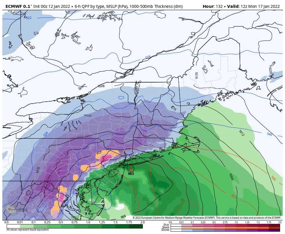
The Winter Storm Threat for this weekend is growing but how close will the Rain/Snow line come to the Philadelphia area? Will it be all snow/rain, will we have a blizzard?
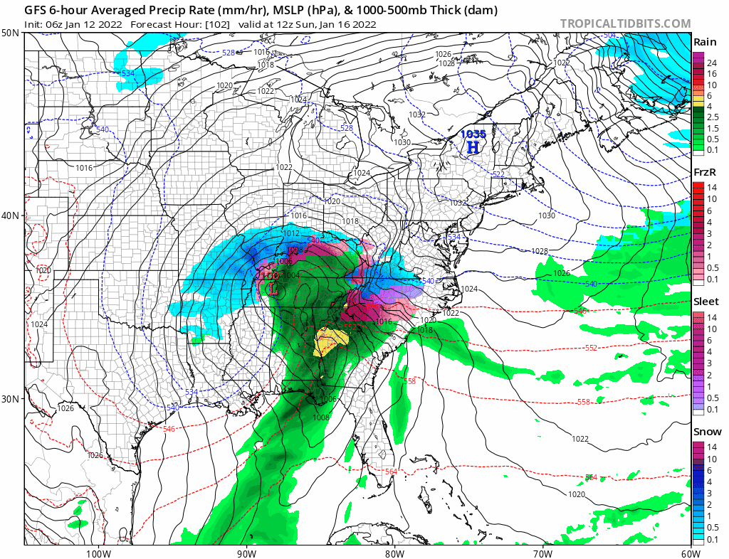
Our team is monitoring the track and models for the Sunday into Monday Winter Storm. At this point we are still in “threat” mode as the threat is there but for who? The models have been going back and forth and we are hoping to see more agreement either today or tomorrow. Here is the latest GFS that just ran this morning. Some areas could see a lot of snow, some will see snow to rain and some will see rain. At this point it appears we will see some snow on Sunday afternoon then a wintery mix/rain on Monday but again this can and will change over the next few days.
The Euro above shows interior PA getting CRUSHED while areas along i95 are mix/rain.
The 06z GFS is NOT a forecast from us, we are just showing the latest model run for this storm.
Here is a guide that we tend to follow with winter storms to bring you the latest information. 7-10 Days out – Pattern Recognition and watching for THREATS 5-7 days out- Paying close attention to TRENDS3 days out- Timing and precip type detailed out 1-2 days out- final calls, detailed timing, nowcasting. Updates will come throughout the next few days, and a full detailed post will come as early as late tomorrow/Friday.
A winter storm will blanket the area with 3-5″ of snow late tonight into the early morning. Friday morning commute will be a mess. If you can stay home please do so and allow the snow plow operators time to clear the road without vehicles on the road.
WINTER WEATHER ADVISORY REMAINS IN EFFECT FROM 10 PM THIS
EVENING TO 10 AM EST FRIDAY...

* WHAT...Snow expected. Total snow accumulations of 3 to 5
  inches.

* WHERE...Central and southwestern New Jersey, southeastern
  Pennsylvania, northeast Maryland and central and northern
  Delaware.

* WHEN...From 10 PM this evening to 10 AM EST Friday.

* IMPACTS...Plan on slippery road conditions. The hazardous
  conditions could impact the morning commute.

* ADDITIONAL DETAILS...A narrow band of heavy snow may result in
  a brief period of snow rates up to 2 inches per hour late
  overnight and locally higher snow totals, though where this
  band may set up is uncertain.

PRECAUTIONARY/PREPAREDNESS ACTIONS...

Slow down and use caution while traveling.
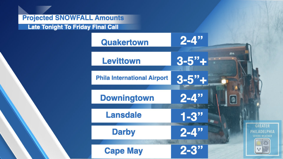
SNOWFALL TOTALS: Along i95 and in the Philly Metro area a general 3-5″ of snow is projected with some areas getting close to 6″ depending on banding setting up. The latest NWS map is attached below as well. Between 3 and 5 inches is currently expected along much of the Interstate 95 corridor from New York City to Philadelphia and Washington..
Again here is a list of locations within the area. We will have a “how to read a map” class in the coming weeks.
Philadelphia
3-5” +
Reading, PA
1-3”
Birdsboro, PA
1-3”
Bristol, PA
3-5” +
Quakertown, PA
2-4”
Morrisville, PA
3-5” +
Perkasie, PA
2-4”
Lehighton, PA
1-3”
Lansford, PA
1-3”
West Chester, PA
2-4”
Phoenixville, PA
2-4”
Coatesville, PA
2-4”
Downingtown, PA
2-4”
Chester, PA
2-4”
Yeadon, PA
2-4”
Darby, PA
2-4”
Atlantic City, NJ
2-4”
Pleasantville, NJ
2-4”
Burlington, NJ
3-5” +
Palmyra, NJ
3-5” +
Camden, NJ
3-5” +
TIMING: The Snow will move into the area around 10/11pm to the east then make its way west. By day break snow will be heavy at times. We will post school closings as they come in on our school closing page.
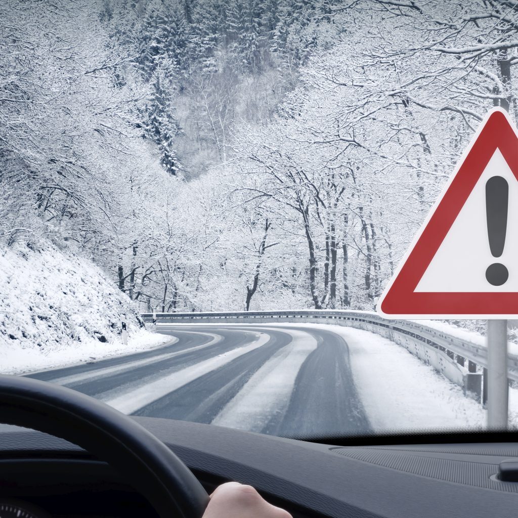
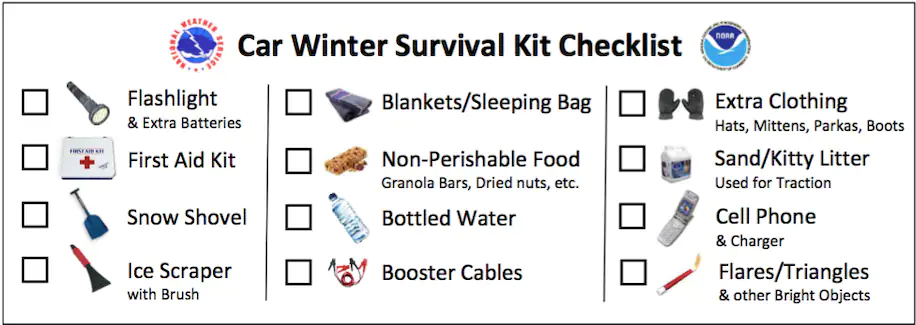
Winter Car Survival Kit. If you are going to be traveling during the height of the storm, have the following in your vehicle in the event you get stranded.
A kit with essential items can help keep you warm while stranded, so make sure your vehicle is packed with these things before you hit the road:
Food: such as snacks such as protein bars, nuts, dried fruit, whole-grain pretzels and crackers.
Water Warm extra clothes: Scarves, mittens, socks and hats. If you’re not wearing the warmest shoes (say, sandals or Crocs), you might also want to throw in a pair of snow boots.
Blankets: When you can’t rely on your car’s heater to keep you warm, you can prevent hypothermia by having blankets to keep your body temperature up. Make sure to have enough for yourself and any other passengers.
Hand warmers, small candles and matches: Keep toasty when rationing fuel.
A flashlight with spare batteries: With daylight being much shorter during winter, there’s a good chance that you may find yourself stranded in the dark. If your car breaks down and there are no inside or outside lights, a flashlight can be an important tool.
Whistle, flares, red bandanna or bright cloth: You can signal for help with these items.
Phone charger: Whether you’re snowed in, you crash or your car breaks down — especially in a low-traffic area — a fully charged phone is a must. Opt for a cellphone adapter to plug into the lighter or, even better, a USB portable battery pack (charge it fully before departing.)
Shovel and cat litter: When your car gets stuck in the snow, digging it out might be the way to go. With a portable snow shovel, you can dig around each wheel. Sprinkling cat litter — or sand — can add traction to get things moving again.
Ice scraper: Snow and ice can impede visibility. Make sure you clear off every inch of your vehicle before hitting the road and after any storm.
Jumper cables: Cold weather can be hard on a car. If your battery fails, having your own set of jumper cables could save you an expensive tow.
Personal hygiene items: Taking care of hygiene inside a car is challenging, but you can keep moist towelettes, period products, garbage bags and plastic ties — to seal any waste — for sanitation. If you wear contacts, have lenses and solution ready. You may want to throw in a travel-size toothbrush and toothpaste kit.
Medication: If you take prescription medication, have at least enough stored for a 72-hour emergency.
Supplies for pets, babies and children: If you’re traveling with animals and children, make sure you have enough supplies for their needs. Include pet food, diapers, infant formula, bottles, wipes and diaper rash cream. To keep small children entertained, stash paper, crayons, books and toys.