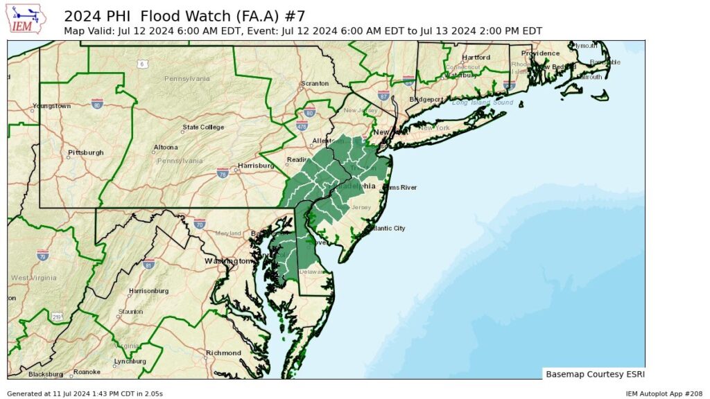
Flood Watch in effect from Friday morning until Saturday afternoon


* WHAT...Flooding caused by excessive rainfall is possible.

* WHEN...From Friday morning through Saturday afternoon.

* IMPACTS...Excessive runoff may result in flooding of rivers,
creeks, streams, and other low-lying and flood-prone locations. Creeks and streams may rise out of their banks. Flooding may occur in poor drainage and urban areas. Low-water crossings may be flooded.

* ADDITIONAL DETAILS...
- Widespread showers and thunderstorms combined with tropical
moisture will result in areas of heavy rainfall across the watch area from Friday morning through Saturday. Rainfall rates may exceed 1 to 2 inches per hour. Forecast rainfall amounts range from about 1 to 2 inches, however localized amounts near 3 to 4 inches are possible.


PRECAUTIONARY/PREPAREDNESS ACTIONS...

You should monitor later forecasts and be alert for possible Flood
Warnings. Those living in areas prone to flooding should be prepared
to take action should flooding develop.

ALERT: Air Quality Alert for Monday July 8

IR QUALITY ALERT IS IN EFFECT FOR MONDAY JULY 8...

The Delaware Valley Regional Planning Commission has issued
a code orange air quality alert Monday for The Philadelphia
Metro area.

A code orange air quality alert means that air pollution
concentrations within the region may become unhealthy for
sensitive groups. Sensitive groups include children...people
suffering from asthma... heart disease or other lung
diseases...and the elderly. The effects of air pollution can
be minimized by avoiding strenuous activity or exercise outdoors.

HEAT ADVISORY IN EFFECT UNTIL 8PM TUESDAY

HEAT ADVISORY IN EFFECT FROM 10 AM MONDAY TO 8 PM EDT TUESDAY…

  • WHAT…Heat index values up to 104 expected.
  • WHERE…Portions of northern Delaware, most of New Jersey, and southeast Pennsylvania.
  • WHEN…From 10 AM Monday to 8 PM EDT Tuesday.
  • IMPACTS…Hot temperatures and high humidity may cause heat illnesses.
  • ADDITIONAL DETAILS…Peak heat indices on Wednesday are forecast to reach or exceed 100 degrees, and therefore an extension of this heat advisory into Wednesday is probable.

PRECAUTIONARY/PREPAREDNESS ACTIONS…

Drink plenty of fluids, stay in an air-conditioned room, stay out of the sun, and check up on relatives and neighbors.

Take extra precautions when outside. Wear lightweight and loose fitting clothing. Try to limit strenuous activities to early morning or evening. Take action when you see symptoms of heat exhaustion and heat stroke.

HEAT ADVISORY IN EFFECT FROM 11 AM TO 7 PM EDT SUNDAY…

  • WHAT…Heat index values up to 102 expected.
  • WHERE…Portions of northern Delaware, central and southern New Jersey, and southeast Pennsylvania.
  • WHEN…From 11 AM to 7 PM EDT Sunday.
  • IMPACTS…Hot temperatures and high humidity may cause heat illnesses.

PRECAUTIONARY/PREPAREDNESS ACTIONS…

Drink plenty of fluids, stay in an air-conditioned room, stay out of the sun, and check up on relatives and neighbors.

Monitor the latest forecasts and warnings for update

Severe Thunderstorm Watch Until Midnight

Severe Thunderstorm Watch for portions of Connecticut Much of New Jersey Southeast New York and Long Island Eastern Pennsylvania Coastal Waters

  • Effective this Wednesday night from 615 PM until Midnight EDT.
  • Primary threats include… Scattered damaging wind gusts to 65 mph possible

SUMMARY…A band of strong to severe thunderstorms is forecast to move east into and across much of the Watch area this evening. A risk for strong to severe gusts (50-65 mph) capable of wind damage will potentially accompany the stronger thunderstorms. An isolated threat for large hail (1 to 1.5 inches in diameter) may exist with any discrete and intense thunderstorms.

The severe thunderstorm watch area is approximately along and 75 statute miles east and west of a line from 15 miles west northwest of Windsor Locks CT to 10 miles southwest of Philadelphia PA. For a complete depiction of the watch see the associated watch outline update (WOUS64 KWNS WOU9).

PRECAUTIONARY/PREPAREDNESS ACTIONS…

REMEMBER…A Severe Thunderstorm Watch means conditions are favorable for severe thunderstorms in and close to the watch area. Persons in these areas should be on the lookout for threatening weather conditions and listen for later statements and possible warnings. Severe thunderstorms can and occasionally do produce tornadoes.

GPSW Heat Advisory

HEAT ADVISORY IN EFFECT 9 am to 9pm WEDNESDAY

…HEAT ADVISORY IN EFFECT FROM 9 AM TO 9 PM EDT WEDNESDAY…

  • WHAT…Heat index values up to 100 expected.
  • WHERE…Portions of northern Delaware, central, northern, and southern New Jersey, and southeast Pennsylvania.
  • WHEN…From 9 AM to 9 PM EDT Wednesday.
  • IMPACTS…Hot temperatures and high humidity may cause heat illnesses.

PRECAUTIONARY/PREPAREDNESS ACTIONS…

Drink plenty of fluids, stay in an air-conditioned room, stay out of the sun, and check up on relatives and neighbors.

Monitor the latest forecasts and warnings for updates.

HEAT ADVISORY NOW IN EFFECT UNTIL 6 AM EDT SATURDAY……EXCESSIVE HEAT WATCH NOW IN EFFECT FROM SATURDAY MORNING THROUGH SUNDAY EVENING…

  • WHAT…For the Heat Advisory, heat index values ranging from 95 to 100 degrees. For the Excessive Heat Watch, dangerously hot conditions with heat index values ranging from 100 to 105 degrees possible.
  • WHERE…Portions of northern Delaware, central, northern, and southern New Jersey, and southeast Pennsylvania.
  • WHEN…For the Heat Advisory, until 6 AM EDT Saturday. For the Heat Advisory, the hottest temperatures and heat indices are forecast to occur on Friday. For the Excessive Heat Watch, from Saturday morning through Sunday evening.
  • IMPACTS…Heat related illnesses increase significantly during extreme heat and high humidity events.

PRECAUTIONARY/PREPAREDNESS ACTIONS…

Drink plenty of fluids, stay in an air-conditioned room, stay out of the sun, and check up on relatives and neighbors.

Do not leave young children and pets in unattended vehicles. Car interiors will reach lethal temperatures in a matter of minutes.

Monitor the latest forecasts and warnings for updates.

HEAT ADVISORY NOW IN EFFECT FROM 10 AM TUESDAY TO 6 AM EDT WEDNESDAY……EXCESSIVE HEAT WATCH IN EFFECT FROM WEDNESDAY MORNING THROUGH SATURDAY EVENING

  • WHAT…For the Heat Advisory, heat index values up to 98 expected. For the Excessive Heat Watch, dangerously hot conditions with heat index values of 100 to 105 possible.
  • WHERE…Portions of northern Delaware, central, northern, and southern New Jersey, and southeast Pennsylvania.
  • WHEN…For the Heat Advisory, from 10 AM Tuesday to 6 AM EDT Wednesday. For the Excessive Heat Watch, from Wednesday morning through Saturday evening.
  • IMPACTS…Heat related illnesses increase significantly during extreme heat and high humidity events.
  • ADDITIONAL DETAILS…A prolonged period of excessive heat with high temperatures in the 90s is expected through this week. The heat is forecast to worsen as the week goes on, with it peaking late in the week and into the weekend. These early season heat events combined with the prolonged nature of it may cause an increase in heat related impacts such heat illnesses or on heat sensitive infrastructure.

PRECAUTIONARY/PREPAREDNESS ACTIONS…

Drink plenty of fluids, stay in an air-conditioned room, stay out of the sun, and check up on relatives and neighbors.

Monitor the latest forecasts and warnings for updates.

FREEZE WARNING in effect…..


FREEZE WARNING IN EFFECT FROM 2 AM TO 9 AM EDT FRIDAY...

* WHAT...Sub-freezing temperatures as low as 29 expected.

* WHERE...Portions of central, northern, northwest and southern
New Jersey and east central and southeast Pennsylvania.

* WHEN...From 2 AM to 9 AM EDT Friday.

* IMPACTS...Frost and freeze conditions will kill crops and
other sensitive vegetation.

PRECAUTIONARY/PREPAREDNESS ACTIONS...

Take steps now to protect tender plants from the cold.

FROST ADVISORY In Effect until 9am

...FROST ADVISORY IN EFFECT FROM 2 AM TO 9 AM EDT MONDAY...

* WHAT...Temperatures as low as 35 will result in frost
  formation.

* WHERE...In New Jersey, Somerset. In Pennsylvania, Delaware,
  Eastern Montgomery and Lower Bucks.

* WHEN...From 2 AM to 9 AM EDT Monday.

* IMPACTS...Frost could kill sensitive outdoor vegetation if
  left uncovered.

PRECAUTIONARY/PREPAREDNESS ACTIONS...

Take steps now to protect tender plants from the cold.