Strong to Severe Storms Possible Monday Afternoon

The Philadelphia region is under the threat of severe weather on Monday.

Late Monday afternoon we will see thunderstorms start to develop. The primary threats are strong wind gusts up to 60-70 mph. We will also see heavy downpours, hail as well as isolated tornadoes are possible. Localized flash flooding is also a big concern.

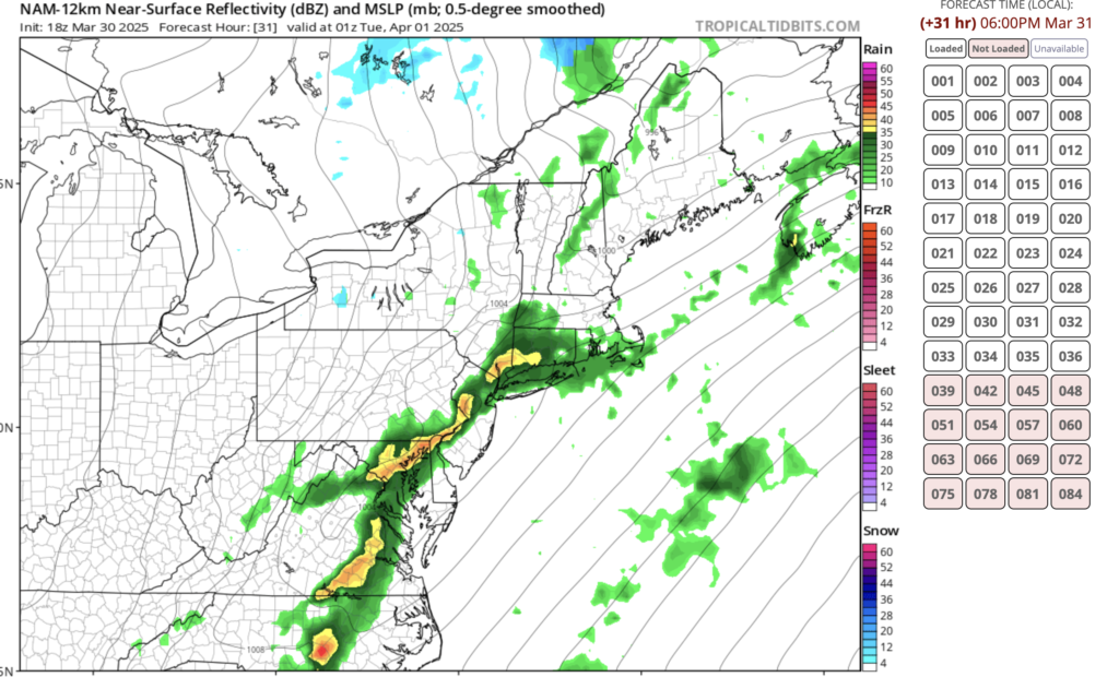
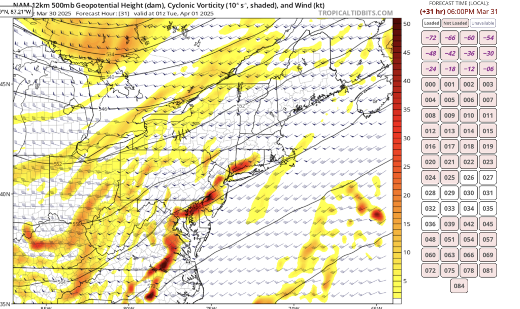
Here are some of the latest model runs that show a strong line of storms around 6pm across the area.

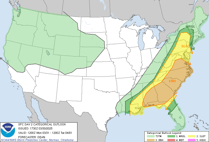
The NWS Storm Prediction Center has the area under a SLIGHT Chance of Severe Weather.


Daily Forecast Monday March 31, 2025 | WEATHER ALERT DAY!

Severe weather is possible today for the area which will include flash flooding. Stay Weather Alert!

Monday

A chance of showers, then showers likely and possibly a thunderstorm after 5pm. Mostly cloudy, with a high near 74. South wind 5 to 15 mph, with gusts as high as 30 mph.

Monday Night

Showers and possibly a thunderstorm. Some of the storms could produce heavy rainfall. Low around 41. Southwest wind 5 to 15 mph becoming northwest after midnight. New precipitation amounts between 1 and 2 inches possible. 

Weekend Forecast March 22 and 23, 2025

Saturday

Partly sunny, with a high near 61. South wind 5 to 15 mph, with gusts as high as 30 mph. 

Saturday Night

Mostly clear, with a low around 28. Northwest wind 10 to 15 mph, with gusts as high as 25 mph. 

Sunday

Mostly sunny, with a high near 49. Northwest wind 5 to 10 mph. 

Sunday Night

A slight chance of rain and snow showers before 11pm, then rain showers likely. Mostly cloudy, with a low around 37. Southeast wind 5 to 10 mph. Chance of precipitation is 70%. Little or

WINTER WEATHER ADVISORY NOW IN EFFECT at 4pm until 7am Wednesday

...WINTER WEATHER ADVISORY NOW IN EFFECT FROM 4 PM THIS AFTERNOON TO
7 AM EST WEDNESDAY...

* WHAT...Snow expected. Total snow accumulations between 2 and 5
inches, with locally higher amounts possible.

* WHERE...Portions of central and southern New Jersey and southeast
Pennsylvania.

* WHEN...From 4 PM this afternoon to 7 AM EST Wednesday.

* IMPACTS...Plan on slippery road conditions. The hazardous
conditions could impact the Tuesday evening and Wednesday morning
commutes.

PRECAUTIONARY/PREPAREDNESS ACTIONS...

Slow down and use caution while traveling. The latest road
conditions for the state you are calling from can be obtained by
calling 5 1 1.


Weekend Forecast February 8 and 9, 2025

Have an awesome weekend!
Winter Weather advisory in effect Saturday 3pm to Sunday morning, and most importantly GO BIRDS

Saturday

Snow likely, mainly after 5pm. Cloudy, with a high near 35. Northwest wind 5 to 10 mph becoming southeast in the afternoon. Chance of precipitation is 60%. New snow accumulation of less than one inch possible. 

Saturday Night

Snow, freezing rain, and sleet before 1am, then a chance of rain or freezing rain between 1am and 4am, then a chance of rain and snow after 4am. Low around 28. Southeast wind 5 to 10 mph becoming northwest after midnight. Chance of precipitation is 100%. New ice accumulation of 0.1 to 0.2 of an inch possible. New snow and sleet accumulation of less than one inch possible. 

Sunday

A chance of snow before 7am. Cloudy through mid morning, then gradual clearing, with a high near 39. Northwest wind 5 to 10 mph, with gusts as high as 20 mph. Chance of precipitation is 30%. Little or no snow accumulation expected. 

Sunday Night

Mostly cloudy, with a low around 23

WINTER WEATHER ADVISORY IN EFFECT FROM 3 PM SATURDAY TO 6 AM ESTSUNDAY


* WHAT…Mixed precipitation is expected. Total snow and sleet
accumulations up to two inches and ice accumulations up to two
tenths of an inch.

* WHERE…Portions of central, northern, and northwest New Jersey
and east central, northeast, and southeast Pennsylvania.

* WHEN…From 3 PM Saturday to 6 AM EST Sunday.

* IMPACTS…Plan on slippery road conditions.

PRECAUTIONARY/PREPAREDNESS ACTIONS…

Slow down and use caution while traveling. The latest road
conditions for the state you are calling from can be obtained by
calling 5 1 1.

Winter Weather Advisory In Effect Midnight Wednesday until 10am Thursday

WINTER WEATHER ADVISORY IN EFFECT FROM MIDNIGHT WEDNESDAY NIGHT
TO 10 AM EST THURSDAY...

* WHAT...Mixed precipitation expected. Total snow and sleet
  accumulations up to one inch and ice accumulations up to one tenth
  of an inch.

* WHERE...Portions of central, northern, northwest, and southern New
  Jersey and southeast Pennsylvania.

* WHEN...From midnight Wednesday Night to 10 AM EST Thursday.

* IMPACTS...Plan on slippery road conditions. The hazardous
  conditions could impact the Thursday morning commute.

PRECAUTIONARY/PREPAREDNESS ACTIONS...

Slow down and use caution while traveling. The latest road
conditions for the state you are calling from can be obtained by
calling 5 1 1.

WIND ADVISORY IN EFFECT FROM 9 AM TO 6 PM EST WEDNESDAY…

WIND ADVISORY IN EFFECT FROM 9 AM TO 6 PM EST WEDNESDAY...

* WHAT...West winds 15 to 25 mph with gusts up to 50 mph expected.

* WHERE...Portions of east central, northeast, and southeast
  Pennsylvania.

* WHEN...From 9 AM to 6 PM EST Wednesday.

* IMPACTS...Gusty winds will blow around unsecured objects. Tree
  limbs could be blown down and a few power outages may result.

PRECAUTIONARY/PREPAREDNESS ACTIONS...

Winds this strong can make driving difficult, especially for high
profile vehicles. Use extra caution.

Snowfall reports from the NWS

UPDATED SNOWFALL REPORTS FROM JANUARY 6TH AS OF 4 PM from the NWS! 

Location Amount Time/Date Provider

...Delaware...

...Kent County...
Houston 8.8 in 0150 PM 01/06 Trained Spotter
Felton 8.5 in 0200 PM 01/06 Trained Spotter
1 N Milford 8.5 in 0350 PM 01/06 Trained Spotter
Felton 8.0 in 1215 PM 01/06 Public
1 E Harrington 7.7 in 0401 PM 01/06 Mesonet
3 SW Magnolia 7.4 in 0321 PM 01/06 Trained Spotter
2 NW Woodside 7.3 in 0346 PM 01/06 Public
1 ESE Woodside 7.0 in 1253 AM 01/06 Trained Spotter
Houston 7.0 in 1119 AM 01/06 Trained Spotter
2 SE Frederica 6.9 in 0359 PM 01/06 Mesonet
4 S Hazlettville 6.4 in 0401 PM 01/06 Mesonet
Frederica 6.4 in 0935 AM 01/06 Public
2 NW Woodside 6.0 in 1010 AM 01/06 Public
Dover 5.6 in 1110 AM 01/06 Public
2 SE Dover 5.5 in 0400 PM 01/06 Mesonet
West Dover 5.4 in 0400 PM 01/06 Mesonet
3 SW Magnolia 5.1 in 1000 AM 01/06 Trained Spotter
Kenton 5.0 in 0938 AM 01/06 Public
Dover Air Force Base 5.0 in 1055 AM 01/06 AWOS
Cheswold 4.1 in 1015 AM 01/06 Public
1 ESE West Dover 4.0 in 1000 AM 01/06 Public
2 S Smyrna Landing 3.2 in 0100 PM 01/06 Mesonet

...New Castle County...
2 NE Blackbird 3.2 in 0357 PM 01/06 Mesonet
2 SSE Mount Pleasant 3.0 in 1226 PM 01/06 Broadcast Media
1 E Glasgow 2.7 in 0355 PM 01/06 Mesonet
Port Penn 2.6 in 0100 PM 01/06 Mesonet
New Castle County Airport 2.2 in 0100 PM 01/06 ASOS
Stockton 2.1 in 0358 PM 01/06 Mesonet
White Clay Creek 2.1 in 0100 AM 01/06 Mesonet
Hockessin 2.0 in 0200 PM 01/06 Trained Spotter
1 SW West Park 2.0 in 0356 PM 01/06 Mesonet
Wilmington Manor 2.0 in 1148 AM 01/06 Public
1 SSE Newark 2.0 in 0100 PM 01/06 Mesonet
1 NE Henry Clay 1.8 in 0230 PM 01/06 Broadcast Media
Monroe Park 1.6 in 0358 PM 01/06 Mesonet
Middletown 1.5 in 0700 AM 01/06 Public
Winterthur 1.4 in 0100 PM 01/06 Mesonet
Hockessin 1.4 in 0100 PM 01/06 Mesonet
Worthland 1.2 in 0355 PM 01/06 Mesonet

...Sussex County...
3 N Delaware Coastal Airport 12.0 in 0200 PM 01/06 Public
Georgetown 12.0 in 0342 PM 01/06 Public
1 E Bridgeville 10.0 in 1219 PM 01/06 Amateur Radio
1 N Milton 9.8 in 0210 PM 01/06 Public
Bethel 9.8 in 1245 PM 01/06 Broadcast Media
2 WSW Long Neck 9.6 in 0100 PM 01/06 Trained Spotter
1 W Georgetown 9.5 in 1210 PM 01/06 Amateur Radio
1 WNW Lewes 9.4 in 0358 PM 01/06 Mesonet
Nassau 9.3 in 0100 PM 01/06 Mesonet
Ellendale 9.3 in 0359 PM 01/06 Mesonet
2 N Bridgeville 9.3 in 0402 PM 01/06 Mesonet
Stockley 9.2 in 0401 PM 01/06 Mesonet
Millville 9.0 in 1200 PM 01/06 Public
Laurel 9.0 in 0309 PM 01/06 Public
Lewes 9.0 in 1200 PM 01/06 Public
2 E Seaford 9.0 in 1219 PM 01/06 Public
5 W Seaford 8.4 in 0400 PM 01/06 Mesonet
1 E Millville 8.2 in 0920 AM 01/06 Public
2 SE Bridgeville 8.0 in 0900 AM 01/06 Public
1 E Selbyville 8.0 in 1200 PM 01/06 Trained Spotter
Delmar 8.0 in 1230 PM 01/06 Trained Spotter
Milford 8.0 in 0130 PM 01/06 Public
1 SE Dagsboro 7.8 in 0359 PM 01/06 Mesonet
1 NNW Bethany Beach 7.0 in 0100 AM 01/06 Mesonet
Dagsboro 7.0 in 0900 AM 01/06 Public
2 WSW Laurel 6.9 in 0358 PM 01/06 Mesonet
1 WNW Seaford 6.0 in 0800 AM 01/06 Trained Spotter
Delmar 5.5 in 0600 AM 01/06 Cocorahs
Long Neck 5.1 in 0841 AM 01/06 Public
4 ENE Delmar 5.0 in 0715 AM 01/06 Cocorahs
3 WSW Georgetown 4.7 in 0730 AM 01/06 Trained Spotter
Ellendale 3.0 in 0500 AM 01/06 Public

...Maryland...

...Caroline County...
Preston 12.0 in 0253 PM 01/06 Public
4 SSE Ingleside 7.0 in 0145 PM 01/06 Trained Spotter
1 WSW American Corner 4.0 in 0600 AM 01/06 Broadcast Media

...Kent County...
Rock Hall 5.0 in 1140 AM 01/06 Trained Spotter

...Queen Annes County...
Stevensville 8.0 in 1100 AM 01/06 Trained Spotter
2 SSW Chester 8.0 in 1100 AM 01/06 Public
2 SSW Carville 7.0 in 0115 PM 01/06 Emergency Mngr
2 WSW Chester 6.5 in 1215 PM 01/06 Public
2 SW Chester 5.0 in 0750 AM 01/06 Public
Chester 3.5 in 0545 AM 01/06 Public

...Talbot County...
Easton 11.5 in 1230 PM 01/06 Public
Royal Oak 6.0 in 1052 AM 01/06 Trained Spotter

...New Jersey...

...Atlantic County...
2 NE Ventnor City 7.0 in 1021 AM 01/06 Public
1 NNE Ventnor City 6.8 in 1035 AM 01/06 Public
Atlantic City 5.5 in 1047 AM 01/06 Public
1 WSW Margate City 5.5 in 1056 AM 01/06 Public
1 N Northfield 5.0 in 0100 PM 01/06 Amateur Radio
Somers Point 4.5 in 0110 PM 01/06 Public
1 SE Egg Harbor City 4.0 in 0100 PM 01/06 Trained Spotter
1 NW Somers Point 4.0 in 0301 PM 01/06 Cocorahs
Atlantic City International 4.0 in 0100 PM 01/06 ASOS
1 E Estell Manor 3.7 in 0100 PM 01/06 Trained Spotter
Egg Harbor Twp 3.1 in 1200 PM 01/06 Trained Spotter
Mays Landing 3.0 in 0900 AM 01/06 Trained Spotter
2 WSW Richland 3.0 in 1230 PM 01/06 Public
Hammonton 2.0 in 0100 PM 01/06 Trained Spotter
1 N Hammonton 1.5 in 1230 PM 01/06 CO-OP Observer
1 SE Absecon 0.5 in 0700 AM 01/06 Trained Spotter

...Burlington County...
Leisuretowne 1.9 in 0111 PM 01/06 Trained Spotter
Willingboro 1.8 in 0123 PM 01/06 Public
1 ESE Moorestown 1.5 in 0100 PM 01/06 Trained Spotter
2 NW South Jersey Regional A 1.4 in 0130 PM 01/06 NWS Employee
Mount Holly WFO 1.4 in 0100 PM 01/06 Official NWS Obs
1 SSE Rancocas 1.3 in 0110 PM 01/06 NWS Employee
2 NNW South Jersey Regional 1.2 in 1245 PM 01/06 CO-OP Observer
Columbus 1.0 in 1035 AM 01/06 Trained Spotter
Burlington 1.0 in 1100 AM 01/06 Public
Fort Dix 1.0 in 1204 PM 01/06 Public
Whitesbog 0.5 in 0930 AM 01/06 Trained Spotter

...Camden County...
1 E Laurel Springs 1.5 in 0130 PM 01/06 Trained Spotter
Lindenwold 1.2 in 0113 PM 01/06 Amateur Radio
Somerdale 1.2 in 0113 PM 01/06 Amateur Radio
Atco 1.2 in 0113 PM 01/06 Amateur Radio
Winslow Twp 1.2 in 0113 PM 01/06 Amateur Radio
2 NNE Gibbsboro 1.0 in 0915 AM 01/06 Public
Cherry Hill Twp 0.3 in 0900 AM 01/06 Public

...Cape May County...
2 NW Cape May 8.1 in 0100 PM 01/06 CO-OP Observer
Cape May 8.0 in 0221 PM 01/06 Public
1 WSW Ocean City 7.4 in 1038 AM 01/06 Public
Rio Grande 7.0 in 0115 PM 01/06 Trained Spotter
Stone Harbor 6.5 in 0124 PM 01/06 Public
1 NE Ocean City 5.0 in 0100 PM 01/06 Amateur Radio
Ocean City 5.0 in 0230 PM 01/06 Public
1 S Lower Twp 5.0 in 0900 AM 01/06 Public
1 W Marmora 4.9 in 0200 PM 01/06 Public
Rio Grande 3.5 in 0835 AM 01/06 Trained Spotter

...Cumberland County...
1 S Newfield 4.0 in 0100 PM 01/06 Amateur Radio
Vineland 3.8 in 0246 PM 01/06 Public
Vineland 3.8 in 0347 PM 01/06 Trained Spotter
Millville 3.5 in 0348 PM 01/06 Trained Spotter
2 N Vineland 2.8 in 0312 PM 01/06 Trained Spotter
Vineland 2.6 in 1003 AM 01/06 Public
Upper Deerfield Twp 2.5 in 0347 PM 01/06 Trained Spotter

...Gloucester County...
Malaga 3.0 in 0200 PM 01/06 Trained Spotter
Malaga 2.5 in 0352 PM 01/06 Trained Spotter
1 W Pitman 2.0 in 0140 PM 01/06 Trained Spotter
1 W Pitman 1.8 in 0228 PM 01/06 Cocorahs
Pitman 1.6 in 0226 PM 01/06 Trained Spotter
Woodbury 1.5 in 0100 PM 01/06 Trained Spotter
Washington Twp 1.4 in 0110 PM 01/06 Trained Spotter

...Hunterdon County...
2 NW Three Bridges 1.1 in 0145 PM 01/06 Trained Spotter
Whitehouse Station 0.8 in 1227 PM 01/06 Public

...Mercer County...
Trenton Mercer Airport 1.8 in 0100 PM 01/06 ASOS
1 NNE Hamilton Square 1.7 in 0115 PM 01/06 Trained Spotter
Pennington 1.5 in 1200 PM 01/06 Amateur Radio
Yardville 1.4 in 1231 PM 01/06 Public
Princeton Junction 1.4 in 0100 PM 01/06 Trained Spotter
1 WNW Hamilton Square 1.3 in 0252 PM 01/06 Trained Spotter
1 S Trenton Mercer Airport 1.3 in 1256 PM 01/06 Trained Spotter
Hamilton Square 1.0 in 1200 PM 01/06 Amateur Radio
Hopewell 1.0 in 1200 PM 01/06 Amateur Radio

...Middlesex County...
Cranbury 1.3 in 0300 PM 01/06 Other Federal
Cheesequake 1.3 in 0349 PM 01/06 Trained Spotter
South River 1.0 in 0150 PM 01/06 Trained Spotter
Woodbridge 1.0 in 0355 PM 01/06 Trained Spotter
North Brunswick Twp 1.0 in 0112 PM 01/06 Public
1 NW Concordia 1.0 in 0120 PM 01/06 Trained Spotter
Metuchen 1.0 in 0130 PM 01/06 Trained Spotter
1 NNE Concordia 0.5 in 1200 PM 01/06 Amateur Radio

...Monmouth County...
1 SW Freehold 2.2 in 0200 PM 01/06 Trained Spotter
Freehold 2.0 in 1155 AM 01/06 Trained Spotter
1 NNW Clarksburg 1.8 in 0300 PM 01/06 Cocorahs
2 WSW Farmingdale 1.8 in 1145 AM 01/06 Public
2 WSW Farmingdale 1.4 in 0130 PM 01/06 Trained Spotter
Leonardo 1.1 in 0225 PM 01/06 Public
Keyport 0.8 in 0324 PM 01/06 Trained Spotter
1 SW Long Branch 0.1 in 0845 AM 01/06 CO-OP Observer

...Morris County...
2 ESE Randolph 0.7 in 0300 PM 01/06 Cocorahs
1 SW Netcong 0.5 in 0100 PM 01/06 Trained Spotter
Green Pond 0.5 in 0100 PM 01/06 Trained Spotter
Chatham 0.3 in 0332 PM 01/06 Public

...Ocean County...
Barnegat 1.4 in 0200 PM 01/06 Trained Spotter
Point Pleasant Beach 1.4 in 0309 PM 01/06 Trained Spotter
3 N Ocean Gate 1.4 in 0102 PM 01/06 Public
1 S Bayville 1.2 in 0100 PM 01/06 Trained Spotter
Brick 1.2 in 0145 PM 01/06 Trained Spotter
1 SSE Stafford Twp. 1.0 in 0145 PM 01/06 Trained Spotter
Jackson 1.0 in 0304 PM 01/06 Trained Spotter
Forked River 1.0 in 1000 AM 01/06 Trained Spotter
2 ESE Ramtown 1.0 in 1200 PM 01/06 Trained Spotter
1 WNW Point Pleasant 1.0 in 0100 PM 01/06 Trained Spotter

...Salem County...
Pennsville 2.0 in 0200 PM 01/06 Trained Spotter

...Somerset County...
2 ENE Montgomery Twp 1.0 in 0100 PM 01/06 Trained Spotter
2 N Bridgewater 1.0 in 0100 PM 01/06 Trained Spotter

...Sussex County...
1 SW High Point 0.5 in 1140 AM 01/06 Trained Spotter

...Warren County...
Stewartsville 1.0 in 0200 PM 01/06 Trained Spotter
1 SSW Washington 0.8 in 1230 PM 01/06 Trained Spotter
Blairstown Twp 0.7 in 1255 PM 01/06 Cocorahs
Hackettstown 0.7 in 0120 PM 01/06 Trained Spotter
Hackettstown 0.4 in 1225 PM 01/06 Trained Spotter

...Pennsylvania...

...Berks County...
Earl Twp 1.5 in 0100 PM 01/06 Trained Spotter
Reading Regional Airport 1.5 in 0100 PM 01/06 ASOS
Spring Twp 1.5 in 0104 PM 01/06 Public
Huffs Church 1.4 in 1115 AM 01/06 Trained Spotter
1 E Birdsboro 1.4 in 1130 AM 01/06 Public
1 NE Sinking Spring 1.0 in 1015 AM 01/06 Public

...Bucks County...
Lower Makefield Twp 2.3 in 0117 PM 01/06 Public
1 W Bensalem 2.1 in 0232 PM 01/06 Public
1 NW Tullytown 2.0 in 0130 PM 01/06 Trained Spotter
1 NNW Langhorne 1.8 in 1250 PM 01/06 Trained Spotter
1 SE Furlong 1.6 in 0145 PM 01/06 Trained Spotter
1 NNW East Rockhill Twp 1.6 in 1245 PM 01/06 Trained Spotter
Lower Southampton Twp 1.5 in 0215 PM 01/06 Trained Spotter
Trumbauersville 1.5 in 1107 AM 01/06 Trained Spotter
Warminster 1.5 in 1200 PM 01/06 Trained Spotter
1 SSE Northampton Twp 1.5 in 1200 PM 01/06 NWS Employee
Bensalem 1.5 in 0114 PM 01/06 Trained Spotter
Fricks 1.0 in 0101 PM 01/06 Trained Spotter
Langhorne 0.3 in 0900 AM 01/06 Trained Spotter

...Carbon County...
Hudsondale 1.0 in 1225 PM 01/06 Public

...Chester County...
1 NW East Nantmeal Twp 2.5 in 1130 AM 01/06 Trained Spotter
Berwyn 2.3 in 0302 PM 01/06 Public
Berwyn 2.3 in 0333 PM 01/06 Public
Jennersville 2.3 in 1245 PM 01/06 Public
West Caln Twp 2.1 in 1243 PM 01/06 Trained Spotter
Easttown Twp 2.0 in 1045 AM 01/06 Public
1 WSW Phoenixville 1.8 in 0200 PM 01/06 Trained Spotter
Exton 1.5 in 0241 PM 01/06 Public
Oxford 1.5 in 0922 AM 01/06 Public
Chesterbrook 1.5 in 1020 AM 01/06 Public
2 WNW Upper Uwchlan Twp 1.5 in 1124 AM 01/06 Trained Spotter
East Coventry Twp 1.3 in 1130 AM 01/06 Trained Spotter
North Coventry Twp 1.3 in 1200 PM 01/06 Public

...Delaware County...
Aston 1.8 in 0130 PM 01/06 Public
Boothwyn 1.8 in 0105 PM 01/06 Public
Morton 1.4 in 1200 PM 01/06 Trained Spotter
Swarthmore 1.4 in 0130 PM 01/06 Trained Spotter
1 SSW Chelsea 1.0 in 1220 PM 01/06 Public

...Lehigh County...
1 NW Upper Macungie Twp. 2.0 in 0115 PM 01/06 Public
Washington Twp 1.6 in 0324 PM 01/06 Trained Spotter
Lehigh Valley International 1.2 in 0100 PM 01/06 ASOS
Salisbury Twp 1.1 in 0120 PM 01/06 Trained Spotter
North Whitehall Twp 0.7 in 1100 AM 01/06 Trained Spotter
1 NNW Schnecksville 0.6 in 1100 AM 01/06 Trained Spotter
Macungie 0.5 in 1000 AM 01/06 Trained Spotter

...Monroe County...
1 N Mount Pocono 0.7 in 0108 PM 01/06 Cocorahs

...Montgomery County...
1 SSE Trappe 2.1 in 1230 PM 01/06 Trained Spotter
North Wales 1.9 in 1230 PM 01/06 Public
Eagleville 1.6 in 1236 PM 01/06 Trained Spotter
1 E Willow Grove 1.5 in 0200 PM 01/06 Trained Spotter
Horsham 1.5 in 0236 PM 01/06 Public
1 ESE Hatboro 1.5 in 1205 PM 01/06 Trained Spotter
2 NNE Upper Dublin Twp 1.5 in 0100 PM 01/06 Public
1 ENE Plymouth Twp 1.5 in 0113 PM 01/06 Public
1 ENE New Hanover Twp 1.4 in 1145 AM 01/06 Trained Spotter

...Northampton County...
Nazareth 1.2 in 1200 AM 01/06 Public
3 E Moore Twp 0.9 in 0200 PM 01/06 Trained Spotter
Hellertown 0.9 in 1240 PM 01/06 Trained Spotter
Bushkill Twp 0.8 in 1005 AM 01/06 Trained Spotter
Martins Creek 0.8 in 1245 PM 01/06 CO-OP Observer
South Easton 0.3 in 0800 AM 01/06 Trained Spotter

...Philadelphia County...
Philadelphia Intl Airport 1.8 in 0100 PM 01/06 ASOS
1 WNW Bustleton 1.5 in 0200 PM 01/06 Trained Spotter
1 SSE Center City 1.2 in 0100 PM 01/06 Trained Spotter
1 SSE Center City 1.2 in 0130 PM 01/06 Public
1 S Philadelphia 1.0 in 0130 PM 01/06 Trained Spotter
Philadelphia 0.4 in 0900 AM 01/06 Cocorahs