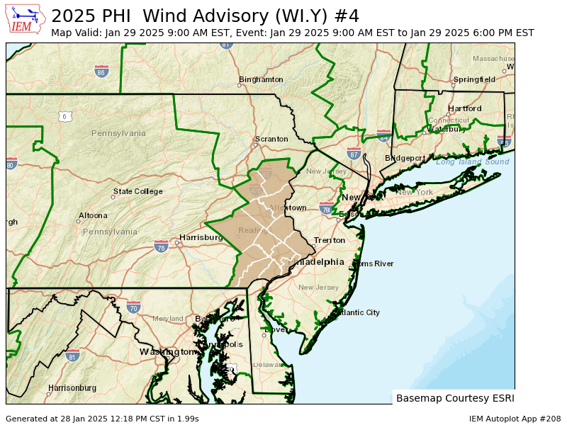
WIND ADVISORY IN EFFECT FROM 9 AM TO 6 PM EST WEDNESDAY...

* WHAT...West winds 15 to 25 mph with gusts up to 50 mph expected.

* WHERE...Portions of east central, northeast, and southeast
  Pennsylvania.

* WHEN...From 9 AM to 6 PM EST Wednesday.

* IMPACTS...Gusty winds will blow around unsecured objects. Tree
  limbs could be blown down and a few power outages may result.

PRECAUTIONARY/PREPAREDNESS ACTIONS...

Winds this strong can make driving difficult, especially for high
profile vehicles. Use extra caution.
UPDATED SNOWFALL REPORTS FROM JANUARY 6TH AS OF 4 PM from the NWS!
Location Amount Time/Date Provider
...Delaware...
...Kent County... Houston 8.8 in 0150 PM 01/06 Trained Spotter Felton 8.5 in 0200 PM 01/06 Trained Spotter 1 N Milford 8.5 in 0350 PM 01/06 Trained Spotter Felton 8.0 in 1215 PM 01/06 Public 1 E Harrington 7.7 in 0401 PM 01/06 Mesonet 3 SW Magnolia 7.4 in 0321 PM 01/06 Trained Spotter 2 NW Woodside 7.3 in 0346 PM 01/06 Public 1 ESE Woodside 7.0 in 1253 AM 01/06 Trained Spotter Houston 7.0 in 1119 AM 01/06 Trained Spotter 2 SE Frederica 6.9 in 0359 PM 01/06 Mesonet 4 S Hazlettville 6.4 in 0401 PM 01/06 Mesonet Frederica 6.4 in 0935 AM 01/06 Public 2 NW Woodside 6.0 in 1010 AM 01/06 Public Dover 5.6 in 1110 AM 01/06 Public 2 SE Dover 5.5 in 0400 PM 01/06 Mesonet West Dover 5.4 in 0400 PM 01/06 Mesonet 3 SW Magnolia 5.1 in 1000 AM 01/06 Trained Spotter Kenton 5.0 in 0938 AM 01/06 Public Dover Air Force Base 5.0 in 1055 AM 01/06 AWOS Cheswold 4.1 in 1015 AM 01/06 Public 1 ESE West Dover 4.0 in 1000 AM 01/06 Public 2 S Smyrna Landing 3.2 in 0100 PM 01/06 Mesonet
...New Castle County... 2 NE Blackbird 3.2 in 0357 PM 01/06 Mesonet 2 SSE Mount Pleasant 3.0 in 1226 PM 01/06 Broadcast Media 1 E Glasgow 2.7 in 0355 PM 01/06 Mesonet Port Penn 2.6 in 0100 PM 01/06 Mesonet New Castle County Airport 2.2 in 0100 PM 01/06 ASOS Stockton 2.1 in 0358 PM 01/06 Mesonet White Clay Creek 2.1 in 0100 AM 01/06 Mesonet Hockessin 2.0 in 0200 PM 01/06 Trained Spotter 1 SW West Park 2.0 in 0356 PM 01/06 Mesonet Wilmington Manor 2.0 in 1148 AM 01/06 Public 1 SSE Newark 2.0 in 0100 PM 01/06 Mesonet 1 NE Henry Clay 1.8 in 0230 PM 01/06 Broadcast Media Monroe Park 1.6 in 0358 PM 01/06 Mesonet Middletown 1.5 in 0700 AM 01/06 Public Winterthur 1.4 in 0100 PM 01/06 Mesonet Hockessin 1.4 in 0100 PM 01/06 Mesonet Worthland 1.2 in 0355 PM 01/06 Mesonet
...Sussex County... 3 N Delaware Coastal Airport 12.0 in 0200 PM 01/06 Public Georgetown 12.0 in 0342 PM 01/06 Public 1 E Bridgeville 10.0 in 1219 PM 01/06 Amateur Radio 1 N Milton 9.8 in 0210 PM 01/06 Public Bethel 9.8 in 1245 PM 01/06 Broadcast Media 2 WSW Long Neck 9.6 in 0100 PM 01/06 Trained Spotter 1 W Georgetown 9.5 in 1210 PM 01/06 Amateur Radio 1 WNW Lewes 9.4 in 0358 PM 01/06 Mesonet Nassau 9.3 in 0100 PM 01/06 Mesonet Ellendale 9.3 in 0359 PM 01/06 Mesonet 2 N Bridgeville 9.3 in 0402 PM 01/06 Mesonet Stockley 9.2 in 0401 PM 01/06 Mesonet Millville 9.0 in 1200 PM 01/06 Public Laurel 9.0 in 0309 PM 01/06 Public Lewes 9.0 in 1200 PM 01/06 Public 2 E Seaford 9.0 in 1219 PM 01/06 Public 5 W Seaford 8.4 in 0400 PM 01/06 Mesonet 1 E Millville 8.2 in 0920 AM 01/06 Public 2 SE Bridgeville 8.0 in 0900 AM 01/06 Public 1 E Selbyville 8.0 in 1200 PM 01/06 Trained Spotter Delmar 8.0 in 1230 PM 01/06 Trained Spotter Milford 8.0 in 0130 PM 01/06 Public 1 SE Dagsboro 7.8 in 0359 PM 01/06 Mesonet 1 NNW Bethany Beach 7.0 in 0100 AM 01/06 Mesonet Dagsboro 7.0 in 0900 AM 01/06 Public 2 WSW Laurel 6.9 in 0358 PM 01/06 Mesonet 1 WNW Seaford 6.0 in 0800 AM 01/06 Trained Spotter Delmar 5.5 in 0600 AM 01/06 Cocorahs Long Neck 5.1 in 0841 AM 01/06 Public 4 ENE Delmar 5.0 in 0715 AM 01/06 Cocorahs 3 WSW Georgetown 4.7 in 0730 AM 01/06 Trained Spotter Ellendale 3.0 in 0500 AM 01/06 Public
...Maryland...
...Caroline County... Preston 12.0 in 0253 PM 01/06 Public 4 SSE Ingleside 7.0 in 0145 PM 01/06 Trained Spotter 1 WSW American Corner 4.0 in 0600 AM 01/06 Broadcast Media
...Kent County... Rock Hall 5.0 in 1140 AM 01/06 Trained Spotter
...Queen Annes County... Stevensville 8.0 in 1100 AM 01/06 Trained Spotter 2 SSW Chester 8.0 in 1100 AM 01/06 Public 2 SSW Carville 7.0 in 0115 PM 01/06 Emergency Mngr 2 WSW Chester 6.5 in 1215 PM 01/06 Public 2 SW Chester 5.0 in 0750 AM 01/06 Public Chester 3.5 in 0545 AM 01/06 Public
...Talbot County... Easton 11.5 in 1230 PM 01/06 Public Royal Oak 6.0 in 1052 AM 01/06 Trained Spotter
...New Jersey...
...Atlantic County... 2 NE Ventnor City 7.0 in 1021 AM 01/06 Public 1 NNE Ventnor City 6.8 in 1035 AM 01/06 Public Atlantic City 5.5 in 1047 AM 01/06 Public 1 WSW Margate City 5.5 in 1056 AM 01/06 Public 1 N Northfield 5.0 in 0100 PM 01/06 Amateur Radio Somers Point 4.5 in 0110 PM 01/06 Public 1 SE Egg Harbor City 4.0 in 0100 PM 01/06 Trained Spotter 1 NW Somers Point 4.0 in 0301 PM 01/06 Cocorahs Atlantic City International 4.0 in 0100 PM 01/06 ASOS 1 E Estell Manor 3.7 in 0100 PM 01/06 Trained Spotter Egg Harbor Twp 3.1 in 1200 PM 01/06 Trained Spotter Mays Landing 3.0 in 0900 AM 01/06 Trained Spotter 2 WSW Richland 3.0 in 1230 PM 01/06 Public Hammonton 2.0 in 0100 PM 01/06 Trained Spotter 1 N Hammonton 1.5 in 1230 PM 01/06 CO-OP Observer 1 SE Absecon 0.5 in 0700 AM 01/06 Trained Spotter
...Burlington County... Leisuretowne 1.9 in 0111 PM 01/06 Trained Spotter Willingboro 1.8 in 0123 PM 01/06 Public 1 ESE Moorestown 1.5 in 0100 PM 01/06 Trained Spotter 2 NW South Jersey Regional A 1.4 in 0130 PM 01/06 NWS Employee Mount Holly WFO 1.4 in 0100 PM 01/06 Official NWS Obs 1 SSE Rancocas 1.3 in 0110 PM 01/06 NWS Employee 2 NNW South Jersey Regional 1.2 in 1245 PM 01/06 CO-OP Observer Columbus 1.0 in 1035 AM 01/06 Trained Spotter Burlington 1.0 in 1100 AM 01/06 Public Fort Dix 1.0 in 1204 PM 01/06 Public Whitesbog 0.5 in 0930 AM 01/06 Trained Spotter
...Camden County... 1 E Laurel Springs 1.5 in 0130 PM 01/06 Trained Spotter Lindenwold 1.2 in 0113 PM 01/06 Amateur Radio Somerdale 1.2 in 0113 PM 01/06 Amateur Radio Atco 1.2 in 0113 PM 01/06 Amateur Radio Winslow Twp 1.2 in 0113 PM 01/06 Amateur Radio 2 NNE Gibbsboro 1.0 in 0915 AM 01/06 Public Cherry Hill Twp 0.3 in 0900 AM 01/06 Public
...Cape May County... 2 NW Cape May 8.1 in 0100 PM 01/06 CO-OP Observer Cape May 8.0 in 0221 PM 01/06 Public 1 WSW Ocean City 7.4 in 1038 AM 01/06 Public Rio Grande 7.0 in 0115 PM 01/06 Trained Spotter Stone Harbor 6.5 in 0124 PM 01/06 Public 1 NE Ocean City 5.0 in 0100 PM 01/06 Amateur Radio Ocean City 5.0 in 0230 PM 01/06 Public 1 S Lower Twp 5.0 in 0900 AM 01/06 Public 1 W Marmora 4.9 in 0200 PM 01/06 Public Rio Grande 3.5 in 0835 AM 01/06 Trained Spotter
...Cumberland County... 1 S Newfield 4.0 in 0100 PM 01/06 Amateur Radio Vineland 3.8 in 0246 PM 01/06 Public Vineland 3.8 in 0347 PM 01/06 Trained Spotter Millville 3.5 in 0348 PM 01/06 Trained Spotter 2 N Vineland 2.8 in 0312 PM 01/06 Trained Spotter Vineland 2.6 in 1003 AM 01/06 Public Upper Deerfield Twp 2.5 in 0347 PM 01/06 Trained Spotter
...Gloucester County... Malaga 3.0 in 0200 PM 01/06 Trained Spotter Malaga 2.5 in 0352 PM 01/06 Trained Spotter 1 W Pitman 2.0 in 0140 PM 01/06 Trained Spotter 1 W Pitman 1.8 in 0228 PM 01/06 Cocorahs Pitman 1.6 in 0226 PM 01/06 Trained Spotter Woodbury 1.5 in 0100 PM 01/06 Trained Spotter Washington Twp 1.4 in 0110 PM 01/06 Trained Spotter
...Hunterdon County... 2 NW Three Bridges 1.1 in 0145 PM 01/06 Trained Spotter Whitehouse Station 0.8 in 1227 PM 01/06 Public
...Mercer County... Trenton Mercer Airport 1.8 in 0100 PM 01/06 ASOS 1 NNE Hamilton Square 1.7 in 0115 PM 01/06 Trained Spotter Pennington 1.5 in 1200 PM 01/06 Amateur Radio Yardville 1.4 in 1231 PM 01/06 Public Princeton Junction 1.4 in 0100 PM 01/06 Trained Spotter 1 WNW Hamilton Square 1.3 in 0252 PM 01/06 Trained Spotter 1 S Trenton Mercer Airport 1.3 in 1256 PM 01/06 Trained Spotter Hamilton Square 1.0 in 1200 PM 01/06 Amateur Radio Hopewell 1.0 in 1200 PM 01/06 Amateur Radio
...Middlesex County... Cranbury 1.3 in 0300 PM 01/06 Other Federal Cheesequake 1.3 in 0349 PM 01/06 Trained Spotter South River 1.0 in 0150 PM 01/06 Trained Spotter Woodbridge 1.0 in 0355 PM 01/06 Trained Spotter North Brunswick Twp 1.0 in 0112 PM 01/06 Public 1 NW Concordia 1.0 in 0120 PM 01/06 Trained Spotter Metuchen 1.0 in 0130 PM 01/06 Trained Spotter 1 NNE Concordia 0.5 in 1200 PM 01/06 Amateur Radio
...Monmouth County... 1 SW Freehold 2.2 in 0200 PM 01/06 Trained Spotter Freehold 2.0 in 1155 AM 01/06 Trained Spotter 1 NNW Clarksburg 1.8 in 0300 PM 01/06 Cocorahs 2 WSW Farmingdale 1.8 in 1145 AM 01/06 Public 2 WSW Farmingdale 1.4 in 0130 PM 01/06 Trained Spotter Leonardo 1.1 in 0225 PM 01/06 Public Keyport 0.8 in 0324 PM 01/06 Trained Spotter 1 SW Long Branch 0.1 in 0845 AM 01/06 CO-OP Observer
...Morris County... 2 ESE Randolph 0.7 in 0300 PM 01/06 Cocorahs 1 SW Netcong 0.5 in 0100 PM 01/06 Trained Spotter Green Pond 0.5 in 0100 PM 01/06 Trained Spotter Chatham 0.3 in 0332 PM 01/06 Public
...Ocean County... Barnegat 1.4 in 0200 PM 01/06 Trained Spotter Point Pleasant Beach 1.4 in 0309 PM 01/06 Trained Spotter 3 N Ocean Gate 1.4 in 0102 PM 01/06 Public 1 S Bayville 1.2 in 0100 PM 01/06 Trained Spotter Brick 1.2 in 0145 PM 01/06 Trained Spotter 1 SSE Stafford Twp. 1.0 in 0145 PM 01/06 Trained Spotter Jackson 1.0 in 0304 PM 01/06 Trained Spotter Forked River 1.0 in 1000 AM 01/06 Trained Spotter 2 ESE Ramtown 1.0 in 1200 PM 01/06 Trained Spotter 1 WNW Point Pleasant 1.0 in 0100 PM 01/06 Trained Spotter
...Salem County... Pennsville 2.0 in 0200 PM 01/06 Trained Spotter
...Somerset County... 2 ENE Montgomery Twp 1.0 in 0100 PM 01/06 Trained Spotter 2 N Bridgewater 1.0 in 0100 PM 01/06 Trained Spotter
...Sussex County... 1 SW High Point 0.5 in 1140 AM 01/06 Trained Spotter
...Warren County... Stewartsville 1.0 in 0200 PM 01/06 Trained Spotter 1 SSW Washington 0.8 in 1230 PM 01/06 Trained Spotter Blairstown Twp 0.7 in 1255 PM 01/06 Cocorahs Hackettstown 0.7 in 0120 PM 01/06 Trained Spotter Hackettstown 0.4 in 1225 PM 01/06 Trained Spotter
...Pennsylvania...
...Berks County... Earl Twp 1.5 in 0100 PM 01/06 Trained Spotter Reading Regional Airport 1.5 in 0100 PM 01/06 ASOS Spring Twp 1.5 in 0104 PM 01/06 Public Huffs Church 1.4 in 1115 AM 01/06 Trained Spotter 1 E Birdsboro 1.4 in 1130 AM 01/06 Public 1 NE Sinking Spring 1.0 in 1015 AM 01/06 Public
...Bucks County... Lower Makefield Twp 2.3 in 0117 PM 01/06 Public 1 W Bensalem 2.1 in 0232 PM 01/06 Public 1 NW Tullytown 2.0 in 0130 PM 01/06 Trained Spotter 1 NNW Langhorne 1.8 in 1250 PM 01/06 Trained Spotter 1 SE Furlong 1.6 in 0145 PM 01/06 Trained Spotter 1 NNW East Rockhill Twp 1.6 in 1245 PM 01/06 Trained Spotter Lower Southampton Twp 1.5 in 0215 PM 01/06 Trained Spotter Trumbauersville 1.5 in 1107 AM 01/06 Trained Spotter Warminster 1.5 in 1200 PM 01/06 Trained Spotter 1 SSE Northampton Twp 1.5 in 1200 PM 01/06 NWS Employee Bensalem 1.5 in 0114 PM 01/06 Trained Spotter Fricks 1.0 in 0101 PM 01/06 Trained Spotter Langhorne 0.3 in 0900 AM 01/06 Trained Spotter
...Carbon County... Hudsondale 1.0 in 1225 PM 01/06 Public
...Chester County... 1 NW East Nantmeal Twp 2.5 in 1130 AM 01/06 Trained Spotter Berwyn 2.3 in 0302 PM 01/06 Public Berwyn 2.3 in 0333 PM 01/06 Public Jennersville 2.3 in 1245 PM 01/06 Public West Caln Twp 2.1 in 1243 PM 01/06 Trained Spotter Easttown Twp 2.0 in 1045 AM 01/06 Public 1 WSW Phoenixville 1.8 in 0200 PM 01/06 Trained Spotter Exton 1.5 in 0241 PM 01/06 Public Oxford 1.5 in 0922 AM 01/06 Public Chesterbrook 1.5 in 1020 AM 01/06 Public 2 WNW Upper Uwchlan Twp 1.5 in 1124 AM 01/06 Trained Spotter East Coventry Twp 1.3 in 1130 AM 01/06 Trained Spotter North Coventry Twp 1.3 in 1200 PM 01/06 Public
...Delaware County... Aston 1.8 in 0130 PM 01/06 Public Boothwyn 1.8 in 0105 PM 01/06 Public Morton 1.4 in 1200 PM 01/06 Trained Spotter Swarthmore 1.4 in 0130 PM 01/06 Trained Spotter 1 SSW Chelsea 1.0 in 1220 PM 01/06 Public
...Lehigh County... 1 NW Upper Macungie Twp. 2.0 in 0115 PM 01/06 Public Washington Twp 1.6 in 0324 PM 01/06 Trained Spotter Lehigh Valley International 1.2 in 0100 PM 01/06 ASOS Salisbury Twp 1.1 in 0120 PM 01/06 Trained Spotter North Whitehall Twp 0.7 in 1100 AM 01/06 Trained Spotter 1 NNW Schnecksville 0.6 in 1100 AM 01/06 Trained Spotter Macungie 0.5 in 1000 AM 01/06 Trained Spotter
...Monroe County... 1 N Mount Pocono 0.7 in 0108 PM 01/06 Cocorahs
...Montgomery County... 1 SSE Trappe 2.1 in 1230 PM 01/06 Trained Spotter North Wales 1.9 in 1230 PM 01/06 Public Eagleville 1.6 in 1236 PM 01/06 Trained Spotter 1 E Willow Grove 1.5 in 0200 PM 01/06 Trained Spotter Horsham 1.5 in 0236 PM 01/06 Public 1 ESE Hatboro 1.5 in 1205 PM 01/06 Trained Spotter 2 NNE Upper Dublin Twp 1.5 in 0100 PM 01/06 Public 1 ENE Plymouth Twp 1.5 in 0113 PM 01/06 Public 1 ENE New Hanover Twp 1.4 in 1145 AM 01/06 Trained Spotter
...Northampton County... Nazareth 1.2 in 1200 AM 01/06 Public 3 E Moore Twp 0.9 in 0200 PM 01/06 Trained Spotter Hellertown 0.9 in 1240 PM 01/06 Trained Spotter Bushkill Twp 0.8 in 1005 AM 01/06 Trained Spotter Martins Creek 0.8 in 1245 PM 01/06 CO-OP Observer South Easton 0.3 in 0800 AM 01/06 Trained Spotter
...Philadelphia County... Philadelphia Intl Airport 1.8 in 0100 PM 01/06 ASOS 1 WNW Bustleton 1.5 in 0200 PM 01/06 Trained Spotter 1 SSE Center City 1.2 in 0100 PM 01/06 Trained Spotter 1 SSE Center City 1.2 in 0130 PM 01/06 Public 1 S Philadelphia 1.0 in 0130 PM 01/06 Trained Spotter Philadelphia 0.4 in 0900 AM 01/06 Cocorahs
Snow, mainly before 2pm. High near 29. Calm wind becoming northeast around 5 mph in the afternoon. Chance of precipitation is 80%. New snow accumulation of 1 to 3 inches is possible.
Monday Night
A slight chance of snow before 3am. Cloudy, then gradual clearing toward daybreak, with a low around 19
A Wind Advisory is ineffective until 10pm. Snow showers possible this morning.
Thursday
Rain and snow showers likely, mainly before 9am. Mostly cloudy, then gradually becoming sunny, with a high near 40. Breezy, with a west wind 20 to 25 mph, with gusts as high as 50 mph.
Thursday Night
Mostly clear, with a low around 26. Breezy, with a west wind 15 to 20 mph, with gusts as high as 35 mph
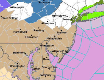
WIND ADVISORY IN EFFECT FROM 10 PM THIS EVENING TO 4 AM EST
THURSDAY...

* WHAT...Northwest winds 20 to 30 mph with gusts of 40 to 50 mph
  expected.

* WHERE...Portions of northern Delaware, central and southern New
  Jersey, and east central and southeast Pennsylvania.

* WHEN...From 10 PM this evening to 4 AM EST Thursday.

* IMPACTS...Gusty winds will blow around unsecured objects. Tree
  limbs could be blown down and a few power outages may result.

PRECAUTIONARY/PREPAREDNESS ACTIONS...

Winds this strong can make driving difficult, especially for high
profile vehicles. Use extra caution.
There continues to be an increased risk of fire spread on Saturday. Relative humidity values Saturday afternoon will drop to 25 to 35 percent across much of the area. These low relative humidity values will combine with northwest winds around 15 mph with gusts up to 25 mph, and even occasionally as high as 30 mph, temperatures in the mid to upper 60s, and abundant sunshine. These conditions will support the spread of any fires that ignite, which could quickly become difficult to control.
Outdoor burning is strongly discouraged. Be sure to properly extinguish or dispose of any potential ignition sources, including smoking materials such as cigarette butts. Refer to your state’s forest fire management agency for more information on burn restrictions in your local area.
Relative humidity values will be lower on Sunday, generally ranging from 20 to 30 percent, but winds will be much lighter. Burn restrictions may still be in place given the very dry conditions and lack of any recent rainfall.
...FROST ADVISORY IN EFFECT FROM 2 AM TO 9 AM EDT MONDAY...

* WHAT...Temperatures as low as 35 will result in frost
  formation.

* WHERE...In New Jersey, Somerset. In Pennsylvania, Delaware,
  Eastern Montgomery and Lower Bucks.

* WHEN...From 2 AM to 9 AM EDT Monday.

* IMPACTS...Frost could kill sensitive outdoor vegetation if
  left uncovered.

PRECAUTIONARY/PREPAREDNESS ACTIONS...

Take steps now to protect tender plants from the cold.
Showers likely, mainly after 4pm. Patchy fog before 11am. Otherwise, cloudy, with a high near 72. Breezy, with an east wind 5 to 10 mph becoming south 15 to 20 mph in the afternoon. Chance of precipitation is 60%. New precipitation amounts of less than a tenth of an inch possible.
Thursday Night
Showers and possibly a thunderstorm. Some of the storms could produce heavy rain. Low around 60. Windy, with a south wind 25 to 30 mph. Chance of precipitation is 100%. New rainfall amounts between a half and three quarters of an inch possible.
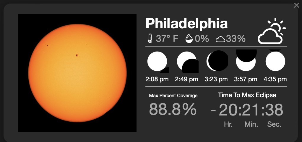
ECLIPSE INFO In Philadelphia, the eclipse will occur from 2:08 p.m. until 4:35 p.m., peaking at 3:23 p.m.
A solar eclipse occurs when the moon comes between the earth and the sun. During a total solar eclipse, the moon blocks the light coming in from the sun and appears to cover up the sun entirely. This will give viewers a glimpse of the sun’s outer atmosphere, known as the corona.
NASA WALLOPS LAUNCHES MONDAY
During the Eclipse today you will be able to see 3 rockets launched from Wallops.
Wallops Flight Facility on Virginia’s Eastern Shore will launch 3 rockets during the solar eclipse to study how Earth’s upper atmosphere is affected when sunlight dims for a moment over part of the planet.
Those rockets will launch at three different times — 45 minutes before the total solar eclipse, during it, and then 45 minutes after the peak local eclipse, and they are expected to reach a maximum altitude of 260 miles. The launch window opens at 2:40 p.m. EDT, with targeted launch times for the three rockets being 2:40 p.m., 3:20 p.m. and 4:05 p.m., but those times are subject to change.
NASA said the three launches are important to gather data on how the sun’s disappearance affects the ionosphere, “creating disturbances that have the potential to interfere with our communications.”