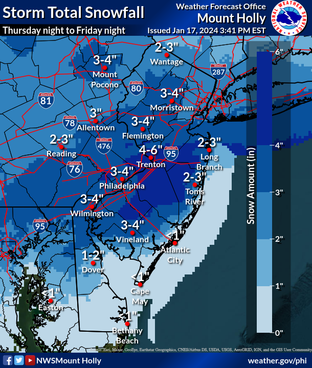
We are seeing snow totals from 3-5″ across most of the area. As we stated in our final call a general 3-5″ with pockets of 4″+.
Snow is still falling in many locations but I am happy to take a break from storm tracking for the weekend. COLD tomorrow and temps will slowly rise over the next week.
More NWS TOTALS
SNOWFALL REPORTS AS OF 330 PM 1/19/24…
Location Amount Time/Date Provider
…Delaware…
…Kent County…
2 S Clayton 4.2 in 0120 PM 01/19 Cocorahs
2 SSE Woodside 4.0 in 0206 PM 01/19 Trained Spotter
Dover Air Force Base 3.7 in 0200 PM 01/19 Other Federal
…New Castle County…
Middletown 5.0 in 0124 PM 01/19 Trained Spotter
Nottingham Manor 4.0 in 0300 PM 01/19 Public
Odessa 3.8 in 1220 PM 01/19 Trained Spotter
Hockessin 3.6 in 0145 PM 01/19 Trained Spotter
1 N Wilmington 3.5 in 1245 PM 01/19 Public
New Castle County Airport 3.3 in 0100 PM 01/19 ASOS
…Sussex County…
Milford 3.8 in 0250 PM 01/19 Broadcast Media
Bethel 1.8 in 0217 PM 01/19 Broadcast Media
…New Jersey…
…Atlantic County…
2 WSW Richland 5.0 in 0200 PM 01/19 Public
Mullica Twp 4.0 in 0200 PM 01/19 Trained Spotter
Somers Point 3.0 in 0245 PM 01/19 Broadcast Media
1 NNE Somers Point 2.6 in 0200 PM 01/19 Broadcast Media
Estell Manor 2.0 in 0100 PM 01/19 CO-OP Observer
1 N Hammonton 2.0 in 0100 PM 01/19 CO-OP Observer
Atlantic City International 1.3 in 0100 PM 01/19 ASOS
…Burlington County…
Medford 5.0 in 0211 PM 01/19 Public
Westampton Twp 4.8 in 0300 PM 01/19 Trained Spotter
Palmyra 3.6 in 0315 PM 01/19 Public
Delanco 3.5 in 0230 PM 01/19 Trained Spotter
Delran 3.5 in 0100 PM 01/19 Public
2 NNW South Jersey Regional 3.4 in 0100 PM 01/19 CO-OP Observer
Columbus 3.3 in 0325 PM 01/19 Public
Marlton 3.3 in 0100 PM 01/19 Trained Spotter
Mount Holly WFO 2.9 in 0100 PM 01/19 Official NWS Obs
1 NNE Rancocas 2.9 in 1250 PM 01/19 NWS Employee
Browns Mills 2.5 in 0130 PM 01/19 Public
Leisuretowne 2.1 in 1240 PM 01/19 Trained Spotter
…Camden County…
Cherry Hill 4.3 in 0300 PM 01/19 Public
Haddon Township 3.7 in 0100 PM 01/19 Trained Spotter
1 SSW Pine Hill 3.5 in 0154 PM 01/19 Trained Spotter
1 NNE Gibbsboro 3.5 in 0100 PM 01/19 Public
Cherry Hill 3.4 in 0100 PM 01/19 Public
Lindenwold 3.4 in 1235 PM 01/19 Trained Spotter
1 NNE Stratford 3.3 in 0120 PM 01/19 Trained Spotter
Greentree 3.1 in 0100 PM 01/19 NWS Employee
Haddonfield 3.0 in 0222 PM 01/19 Public
Blackwood 2.5 in 0110 PM 01/19 Public
…Gloucester County…
Gibbstown 5.5 in 0245 PM 01/19 Public
Paulsboro 4.3 in 0311 PM 01/19 Public
Pitman 4.0 in 0130 PM 01/19 Trained Spotter
Woodbury 4.0 in 1245 PM 01/19 Public
Glassboro 3.3 in 0145 PM 01/19 Public
1 SSE Mullica Hill 3.0 in 0140 PM 01/19 Trained Spotter
…Hunterdon County…
Flemington 2.0 in 0225 PM 01/19 Public
…Mercer County…
2 SW Pennington 4.0 in 0250 PM 01/19 Public
Hamilton Square 3.8 in 0200 PM 01/19 Public
2 WNW Allentown 3.5 in 0315 PM 01/19 Public
Lawrenceville 3.3 in 0115 PM 01/19 Trained Spotter
1 N North Princeton 3.2 in 0130 AM 01/19 Trained Spotter
Trenton Mercer Airport 2.8 in 0100 PM 01/19 ASOS
Woodsville 2.8 in 1230 PM 01/19 Trained Spotter
1 NNE Hamilton Square 2.6 in 1230 PM 01/19 Trained Spotter
Hamilton Twp 2.5 in 1220 PM 01/19 Trained Spotter
…Middlesex County…
Cranbury 3.4 in 0230 PM 01/19 Other Federal
East Brunswick 3.0 in 0145 PM 01/19 Trained Spotter
North Brunswick 2.8 in 0123 PM 01/19 Trained Spotter
Highland Park 2.7 in 0257 PM 01/19 Public
Metuchen 2.7 in 0230 PM 01/19 Trained Spotter
Edison 2.6 in 0315 PM 01/19 Newspaper
South Plainfield 1.0 in 0310 PM 01/19 Trained Spotter
…Monmouth County…
Freehold 3.5 in 0325 PM 01/19 Trained Spotter
1 SW Howell 3.0 in 0300 PM 01/19 Trained Spotter
2 SSW Farmingdale 3.0 in 0140 PM 01/19 Public
1 E Perrineville 3.0 in 0130 PM 01/19 Public
1 SSW Freehold 3.0 in 0100 PM 01/19 Trained Spotter
Tinton Falls 1.4 in 0130 PM 01/19 Broadcast Media
…Morris County…
Butler 1.0 in 0315 PM 01/19 Trained Spotter
…Ocean County…
Brick 2.5 in 0205 PM 01/19 Public
2 SE Forked River 2.4 in 0310 PM 01/19 Trained Spotter
Barnegat Twp 2.4 in 0230 PM 01/19 Trained Spotter
Whiting 2.3 in 1236 PM 01/19 Public
Beachwood 2.0 in 0200 PM 01/19 Public
Point Pleasant 2.0 in 0200 PM 01/19 Trained Spotter
Little Egg Harbor Twp 1.0 in 0100 PM 01/19 Trained Spotter
Surf City 0.5 in 1244 PM 01/19 Public
…Somerset County…
Kendall Park 2.5 in 0110 PM 01/19 Public
…Sussex County…
4 WSW Wantage Twp 1.3 in 1200 PM 01/19 Trained Spotter
…Pennsylvania…
…Berks County…
1 N Union Twp 4.1 in 0250 PM 01/19 Public
Earl Twp 3.3 in 0100 PM 01/19 Trained Spotter
Huffs Church 3.0 in 0230 PM 01/19 Public
Spring Twp 3.0 in 1200 PM 01/19 Public
Reading Regional Airport 2.9 in 0100 PM 01/19 ASOS
…Bucks County…
Levittown 4.2 in 0230 PM 01/19 Trained Spotter
1 NNW Langhorne 3.5 in 0200 PM 01/19 Trained Spotter
1 SW Lower Southampton Twp 3.5 in 1215 PM 01/19 Public
East Rockhill Twp 3.1 in 0100 PM 01/19 Trained Spotter
Hilltown Twp 3.0 in 0100 PM 01/19 Trained Spotter
1 SW Gardenville 3.0 in 1248 PM 01/19 Public
1 SSE Bristol Twp 2.8 in 1245 PM 01/19 Trained Spotter
…Carbon County…
Hudsondale 1.9 in 0200 PM 01/19 Public
…Chester County…
Downington 5.0 in 0200 PM 01/19 Public
Easttown Twp 4.5 in 0249 PM 01/19 Public
East Nantmeal Twp 4.0 in 0200 PM 01/19 Trained Spotter
Exton 4.0 in 0130 PM 01/19 Public
East Coventry Twp 3.5 in 0300 PM 01/19 Trained Spotter
Elk Twp 3.0 in 0200 PM 01/19 Public
Schuylkill Twp 3.0 in 0130 PM 01/19 Public
2 WNW Upper Uwchlan Twp 2.8 in 1200 PM 01/19 Public
…Delaware County…
Morton 4.5 in 0200 PM 01/19 Trained Spotter
Boothwyn 4.3 in 0115 PM 01/19 Trained Spotter
Eddystone 4.2 in 0300 PM 01/19 Public
Collingdale 4.0 in 0222 PM 01/19 Public
Secane 4.0 in 0130 PM 01/19 Trained Spotter
Chester Heights 3.1 in 0212 PM 01/19 Public
…Lehigh County…
Macungie 2.8 in 0230 PM 01/19 Trained Spotter
Whitehall Twp 1.5 in 1230 PM 01/19 Trained Spotter
Lehigh Valley International 1.3 in 0100 PM 01/19 ASOS
…Monroe County…
1 N Mount Pocono 1.4 in 0216 PM 01/19 Trained Spotter
…Montgomery County…
Norristown 5.2 in 0320 PM 01/19 Trained Spotter
King of Prussia 4.3 in 0325 PM 01/19 Public
Glenside 4.3 in 0310 PM 01/19 Trained Spotter
Hatboro 4.1 in 0300 PM 01/19 Public
Skippack 4.0 in 0310 PM 01/19 Public
Wyndmoor 4.0 in 0225 PM 01/19 Public
1 NE Willow Grove 4.0 in 1245 PM 01/19 Public
East Norriton 3.9 in 0115 PM 01/19 Public
3 NW Trappe 3.5 in 0230 PM 01/19 Public
Lansdale 3.5 in 0120 PM 01/19 Public
New Hanover Twp 3.3 in 0300 PM 01/19 Trained Spotter
Glenside 3.0 in 1235 PM 01/19 Public
Ambler 3.0 in 1200 PM 01/19 Public
1 E Elkins Park 2.6 in 1230 PM 01/19 Trained Spotter
1 SSE Spring Mount 1.7 in 0230 PM 01/19 Trained Spotter
…Northampton County…
Hellertown 1.7 in 0300 PM 01/19 Trained Spotter
North Catasauqua 1.4 in 0158 PM 01/19 Public
2 ESE Moore Twp 1.3 in 0220 PM 01/19 Public
Nazareth 1.3 in 0125 PM 01/19 Trained Spotter
Martins Creek 1.0 in 0300 PM 01/19 Trained Spotter
…Philadelphia County…
1 WSW Belmont 5.1 in 0200 PM 01/19 Public
Fox Chase 3.9 in 0320 PM 01/19 Public
Philadelphia International A 2.9 in 0100 PM 01/19