Late Thursday night into Friday we will see our second winter storm of the season and of the week! This storm will bring a general 2-4″ of snow across more os the area BUT a Norlun Trough is going to set up and could impact higher snow totals within a few mile distance.
What is a NORLUN TROUGH
Norlun Trough is an axis of shifting winds on the NW side of a low. They are known to bring very localized, very heavy bands of snow so that one town gets buried and the next barely receives an inch. These features are wicked fickle and are very hard to forecast. 30 miles can make the difference between 1″ and 11″ and it’s hard to tell where exactly they’ll set up. (THIS IS NOT EXPECTED HERE, This is JUST the definition and NOT a forecast)
We are going to keep an eye on this but it appears the trough could set up between Philly and Trenton.

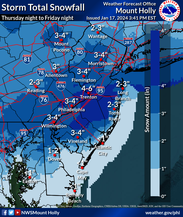
SNOW Totals:
At this point Generally 2-4″ of snow is possible. Trenton and Lower Bucks looks to be 4-6″ and even could see a lot more depending on where the trough sets up. The MAIN key factor is where the trough sets up.
A FULL REPORT with TIMING and FINAL numbers will be posted in the morning. The WINTER WEATHER ADVISORY will go into effect Late Thursday night until Friday night. We will have more info late tonight and around lunch time tomorrow.