WIND CHILL ADVISORY IN EFFECT FROM 6 PM FRIDAY TO 10 AM EST
SATURDAY...
* WHAT...Very cold wind chills expected. Wind chills as low as
10 below zero.
* WHERE...Portions of central, northern and southern Delaware,
northeast Maryland, central, northern, northwest and southern
New Jersey and southeast Pennsylvania.
* WHEN...From 6 PM Friday to 10 AM EST Saturday.
* IMPACTS...The cold wind chills could result in hypothermia if
precautions are not taken.
* ADDITIONAL DETAILS...A strong cold front will move through
Friday bringing a very sharp drop in temperatures with strong
southerly winds shifting to strong westerly. By Friday evening,
this combination of wind and cold will result in wind chills
dropping below zero with wind chills as low as 10 below expected
overnight Friday night into early Saturday.
PRECAUTIONARY/PREPAREDNESS ACTIONS...
Use caution while traveling outside. Wear appropriate clothing, a
hat, and gloves.
WIND ADVISORY IN EFFECT FROM 6 AM TO 7 PM EST FRIDAY...
* WHAT...Southwest winds 20 to 30 mph with gusts up to 50 mph
expected.
* WHERE...Portions of central, northern and southern Delaware,
northeast Maryland, central, northern, northwest and southern
New Jersey and east central, northeast and southeast
Pennsylvania.
* WHEN...From 6 AM to 7 PM EST Friday.
* IMPACTS...Gusty winds could blow around unsecured objects.
Tree limbs could be blown down and a few power outages may
result.
* ADDITIONAL DETAILS...A brief period of wind gusts near 60 mph is
possible as a strong cold front races through the area from
late morning to early afternoon Friday.
PRECAUTIONARY/PREPAREDNESS ACTIONS...
Use extra caution when driving, especially if operating a high
profile vehicle. Secure outdoor objects.
An ARCTIC BLAST will cause major issues Friday afternoon into Friday evening. This storm will impact millions across the US towards the end of the week. We will see 1-2″ of rain before a huge drop in temps Friday afternoon. Around lunchtime we will see temps in the upper 50s but as this cold front moves across the area rain will change to snow for some and any standing water will freeze. We will also see very high winds on Friday afternoon.
TIMING: We will see rain move in Thursday evening, it will be heavy at times in the overnight hours into Friday morning. That is when it will get wild. After 1pm we will see heavy rain that will change over to some backend snow as the cold front pushes through. While yes snow is possible the main concern is a FLASH FREEZE. Snow showers should wrap up by 8pm. This will set up for the coldest Christmas eve and day in over 30 years.
==========
How Much Snow:
The models have shown the chance of snow on the back end. A general C-1″ is possible for areas to the west of Philly while the Philly Metro and i95 corridor will see generally coating. PLEASE remember this is a complex storm and a lot of variables that could change.
FLASH FREEZE: A flash freeze is as it sounds. Once temperatures drop below 32°F, there is a chance for any liquid water to quickly become ice. That ice can cause major accidents on roadways in an instant. Please avoid all travel Friday afternoon if possible.
Here are some tips on how to prepare and avoid ice:
Know the forecast. Understand where the temperatures will be before you head out and if there is a risk for ice.
Make sure you have proper tires. While a total sheet of black ice can make any traction nearly impossible, winter tires are better equipped to handle ice.
Watch for “wet” roads. When driving in the winter, understand that what looks like a wet road could be ice.
Know that bridges and overpasses freeze before other surfaces.
Our team is monitoring this system and will bring you the latest updates later this evening. Please avoid all travel Friday afternoon.
FLOOD ADVISORY IN EFFECT UNTIL MIDNIGHT EST TONIGHT...
* WHAT...Urban and small stream flooding caused by excessive
rainfall is expected.
* WHERE...Portions of northern Delaware...New Jersey...and southeast
Pennsylvania...including the following counties...in northern
Delaware...New Castle. In New Jersey...Burlington, Camden,
Gloucester, and Mercer. In southeast Pennsylvania...Bucks,
Delaware, Montgomery, and Philadelphia.
* WHEN...Until midnight EST.
* IMPACTS...Minor flooding in low-lying and poor drainage areas.
* ADDITIONAL DETAILS...
- At 848 PM EST, Doppler radar and automated rain gauges
indicated heavy rain. This is causing urban and small stream
flooding. Overflowing poor drainage areas have already caused
minor flooding across portions of the advisory area. Between
0.5 and 1.5 inches of rain have fallen.
- Some locations that may experience flooding include...
Philadelphia, Trenton, Camden, Wilmington, Newark, Gloucester
City, Cherry Hill, Bensalem, Mount Laurel, Ewing, Norristown,
and Chester.
- This includes the following highways...
New Jersey Turnpike between exits 3 and 7A.
Pennsylvania Turnpike between mile markers 331 and 359.
Interstate 95 in Pennsylvania between mile markers 0 and 40.
Interstate 95 in Delaware between mile markers 2 and 23.
Interstate 76 in Pennsylvania between mile markers 330 and
351.
Interstate 76 in New Jersey between mile markers 0 and 3.
Interstate 295 in New Jersey between mile markers 11 and 76.
Interstate 195 in New Jersey between mile markers 0 and 5.
- http://www.weather.gov/safety/flood
WINTER WEATHER ADVISORY IN EFFECT FROM 5 AM TO NOON EST
THURSDAY...
* WHAT...Snow mixed with sleet and freezing rain. Total snow
accumulations of up to one inch and ice accumulations of up to
several hundredths of an inch of ice.
* WHERE...Portions of northern Delaware, southern New Jersey and
southeast Pennsylvania.
* WHEN...From 5 AM to noon EST Thursday.
* IMPACTS...Plan on slippery road conditions. The hazardous
conditions could impact the morning commute.
* ADDITIONAL DETAILS...A mix of snow, sleet, and freezing rain
will move in to the area from west to east Thursday morning.
This may last up to a few hours in places, especially north of
the I-95 corridor. An eventual change to rain will occur from
south to north by Thursday afternoon. Near and south of the I-95
corridor, any snow accumulation should be minimal, if any, but
up to a few hundredths of an inch of ice could occur. North of
the I-95 corridor, up to an inch of snow and sleet could fall
along with a thin layer of ice accretion.
PRECAUTIONARY/PREPAREDNESS ACTIONS...
Slow down and use caution while traveling.
The latest road conditions for the state you are calling from can
be obtained by calling 5 1 1.
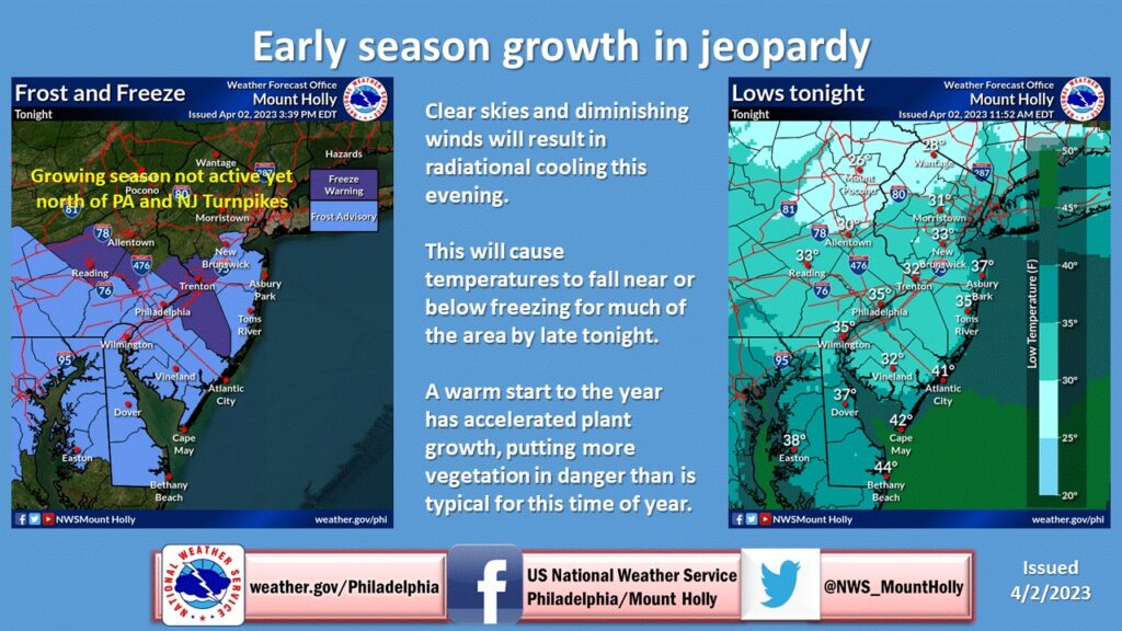
The NWS has issued the final freeze warning for the year. As most of the growing season has ended.
FREEZE WARNING REMAINS IN EFFECT FROM 11 PM THIS EVENING TO
9 AM EST TUESDAY...
* WHAT...Sub-freezing temperatures as low as 28 expected.
* WHERE...In New Jersey, Salem, Gloucester, Camden, Northwestern
Burlington, Cumberland and Cape May. In Pennsylvania,
Delaware, Philadelphia, Eastern Montgomery and Lower Bucks.
* WHEN...From 11 PM this evening to 9 AM EST Tuesday.
* IMPACTS...Frost and freeze conditions will kill crops and
other sensitive vegetation.
PRECAUTIONARY/PREPAREDNESS ACTIONS...
Take steps now to protect tender plants from the cold.
FREEZE WARNING IN EFFECT FROM MIDNIGHT TONIGHT TO 8 AM EST
MONDAY...
* WHAT...Sub-freezing temperatures with minimum values ranging
from 28 to 32 degrees are expected.
* WHERE...Portions of southern New Jersey and southeast
Pennsylvania.
* WHEN...From midnight tonight to 8 AM EST Monday.
* IMPACTS...Frost and freeze conditions will kill crops and
other sensitive vegetation.
* ADDITIONAL DETAILS...Sub-freezing temperatures are expected
again Monday night through Tuesday morning.
PRECAUTIONARY/PREPAREDNESS ACTIONS...
Take steps now to protect tender plants from the cold.
FREEZE WATCH REMAINS IN EFFECT FROM LATE SUNDAY NIGHT THROUGH
MONDAY MORNING...
* WHAT...Sub-freezing temperatures as low as 27 possible.
* WHERE...Portions of southern New Jersey and southeast
Pennsylvania.
* WHEN...From late Sunday night through Monday morning.
* IMPACTS...Frost and freeze conditions will kill crops and other
sensitive vegetation.
PRECAUTIONARY/PREPAREDNESS ACTIONS...
Take steps now to protect tender plants from the cold.
FREEZE WARNING IN EFFECT FROM 1 AM TO 8 AM EST WEDNESDAY
* WHAT...Minimum temperatures as low as 31 degrees. This will
also result in some areas of frost formation.
* WHERE...In New Jersey, Northwestern Burlington. In
Pennsylvania, Eastern Montgomery and Lower Bucks.
* WHEN...From 1 AM to 8 AM EST Wednesday.
* IMPACTS...Frost and freeze conditions will kill crops and other
sensitive vegetation.
PRECAUTIONARY/PREPAREDNESS ACTIONS...
Take steps now to protect tender plants from the cold.
FROST ADVISORY is issued until 8am for the following locations:
* WHAT...Temperatures in the middle 30s and a light wind will
allow for the development of frost.
* WHERE...Parts of southeastern Pennsylvania, central and
southern New Jersey, Delaware and eastern Maryland.
* WHEN...From midnight tonight until 9:00 AM Wednesday.
* IMPACTS...Frost could kill sensitive outdoor vegetation if left
unprotected.
PRECAUTIONARY/PREPAREDNESS ACTIONS...
Take steps now to protect sensitive plants from the cold.
COASTAL FLOOD ADVISORY REMAINS IN EFFECT FROM 1 PM THIS
AFTERNOON TO 9 PM EDT TUESDAY...
* WHAT...Up to one foot of inundation above ground level
expected in low-lying areas near shorelines and tidal
waterways.
* WHERE...In New Jersey, Gloucester, Camden and Northwestern
Burlington. In Pennsylvania, Delaware, Philadelphia and Lower
Bucks.
* WHEN...From 1 PM this afternoon to 9 PM EDT Tuesday.
* IMPACTS...At this level, flooding begins on the most
vulnerable roads along tidal waterways. Some partial or full
road closures are possible.
PRECAUTIONARY/PREPAREDNESS ACTIONS...
If travel is required, allow extra time as some roads may be
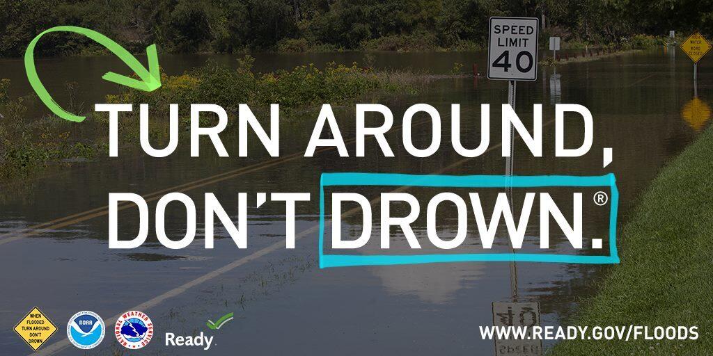
closed. Do not drive around barricades or through water of
unknown depth. Take the necessary actions to protect flood-prone
property.
&&