Jan
16
Daily Forecast Wednesday January 17, 2024
Have a great day! Stay warm!
Wednesday
Sunny, with a high near 24. West wind 10 to 15 mph.
Wednesday Night
Mostly clear, with a low around 18

Have a great day! Stay warm!
Wednesday
Sunny, with a high near 24. West wind 10 to 15 mph.
Wednesday Night
Mostly clear, with a low around 18

By storms end we will have 2-4″ of snow.
Tuesday
Snow and freezing rain ending around 1pm. High near 35.
Tuesday Night
Partly cloudy, with a low around 17. Northwest wind 5 to 10 mph.

Snow will move into the area this evening and last until mid to late morning tomorrow.
M.L.King Day
Mostly cloudy, with a high near 32. West wind around 5 mph.
Monday Night
Snow likely, mainly after 10pm. Cloudy, with a low around 25. Southwest wind around 5 mph becoming calm. Chance of precipitation is 70%. New snow accumulation of 1 to 2 inches possible.
We have flood warnings and watches in effect until 5pm tonight. We are tracking snow for early in the week. Stay turned over the weekend for details on it.
Saturday
A chance of rain, mainly before noon. Mostly cloudy, then gradually becoming sunny, with a temperature falling to around 43 by 5pm. Breezy, with a west wind 15 to 25 mph, with gusts as high as 45 mph. Chance of precipitation is 30%. New precipitation amounts between a tenth and quarter of an inch possible.
Saturday Night
Mostly clear, with a low around 30. Breezy, with a southwest wind 15 to 20 mph, with gusts as high as 35 mph.
Sunday
A chance of snow after 5pm. Mostly sunny, with a high near 40. Southwest wind 10 to 15 mph, with gusts as high as 25 mph. Chance of precipitation is 30%. Little or no snow accumulation expected.
Sunday Night
A chance of snow before 8pm. Mostly clear, with a low around 19. Chance of precipitation is 30%.

Have a GREAT Friday! Rain will move in this afternoon!
Friday
A chance of rain after 5pm. Increasing clouds, with a high near 44. Light and variable wind becoming southeast 5 to 10 mph in the afternoon.
Friday Night
Rain. Low around 42. Breezy, with an east wind 15 to 20 mph becoming south after midnight. Winds could gust as high as 35 mph.
Our next shot of rain moves into the area on Friday afternoon in through Saturday. Also tracking another system on Monday/Tuesday that MIGHT bring snow to parts of the area.
Thursday
Sunny, with a high near 46. Southwest wind 5 to 10 mph.
Thursday Night
Mostly clear, with a low around 30
Have a great Wednesday!
Wednesday
A slight chance of showers before 1pm. Mostly cloudy, with a high near 48. Breezy, with a southwest wind 15 to 25 mph, with gusts as high as 35 mph. Chance of precipitation is 20%.
Wednesday Night
Partly cloudy, with a low around 30.
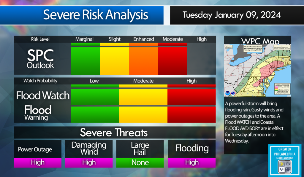
A powerful storm will be 2-3″ upwards of 4″ to the area starting early afternoon on Tuesday into Wednesday. The Philadelphia area will see 40-50 mph winds with gust to 60 mph. Shore points could see wind gust over 65 mph. This storm will cause localized flooding. Expect power outages.
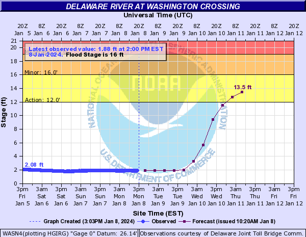
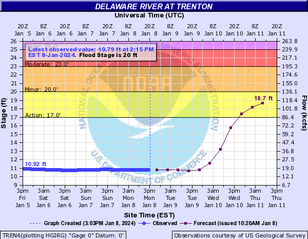
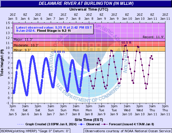
The following are the projected RIVER FLOOD STAGE for The Delaware at Washington Crossing, Trenton and Burlington.
Flood Stage
Watches and Warnings:
WIND ADVISORY:

WIND ADVISORY IN EFFECT FROM 5 PM TUESDAY TO 3 AM EST WEDNESDAY.
WHEN…From 5 PM Tuesday to 3 AM EST Wednesday.
IMPACTS…Gusty winds could blow around unsecured objects. Tree limbs could be blown down and a few power outages may result.
ADDITIONAL DETAILS…
Saturated ground after multiple rounds of heavy rainfall over the last month has made trees more vulnerable to becoming uprooted with strong winds.
PRECAUTIONARY/PREPAREDNESS ACTIONS...
Use extra caution when driving, especially if operating a high profile vehicle. Secure outdoor objects.

FLOOD WATCH IN EFFECT FROM TUESDAY AFTERNOON THROUGH WEDNESDAY AFTERNOON.
WHEN…
From Tuesday afternoon through Wednesday afternoon.
IMPACTS…
Excessive runoff may result in flooding of rivers, creeks, streams, and other low-lying and flood-prone locations. *
ADDITIONAL DETAILS –
Rainfall of 1 to 3 inches possible Tuesday through early Wednesday, with the heaviest rain falling Tuesday night. The ground remains very saturated following multiple rounds of heavy rainfall over the last month. A period of higher hourly rainfall rates is possible during Tuesday night which would enhance the potential for flooding, particularly in the urban areas. Tidal inundation combined with runoff in coastal areas may significantly elevate the flood risk, especially if occurring during times of high tide.
COASTAL FLOOD WATCH IN EFFECT FROM TUESDAY EVENING THROUGH LATE TUESDAY NIGHT…
WHERE...
In New Jersey, Mercer, Gloucester, Camden and Northwestern Burlington. In Pennsylvania, Delaware, Philadelphia and Lower Bucks. * WHEN…From Tuesday evening through late Tuesday night.
IMPACTS…
At this level, widespread roadway flooding occurs along tidal waterways. Some roads become impassable. Minor damage to vulnerable structures may begin to occur.
ADDITIONAL DETAILS.
Tidal flooding could be significantly enhanced by an influx of fresh water runoff due to heavy rain Tuesday night.
PRECAUTIONARY/PREPAREDNESS ACTIONS…
If travel is required, allow extra time as some roads may be closed. Do not drive around barricades or through water of unknown depth. Take the necessary actions to protect flood-prone property

Today is a weather alert day! Damaging winds, heavy rain will lead to flooding and power outages.
Tuesday
Rain, mainly after 2pm. High near 51. Breezy, with an east wind 5 to 10 mph increasing to 15 to 20 mph in the afternoon. Chance of precipitation is 90%. New precipitation amounts between a half and three quarters of an inch possible.
Tuesday Night
Rain. The rain could be heavy at times. Low around 47. Windy, with a southeast wind 25 to 30 mph, with gusts as high as 45 mph. Chance of precipitation is 100%. New precipitation amounts between 1 and 2 inches possible
Have a great Monday! Flood Watch and Coastal Flood Advisories are up for tomorrow.
Monday
Sunny, with a high near 43. Northwest wind around 10 mph, with gusts as high as 20 mph.
Monday Night
Increasing clouds, with a low around 28.