As we begin the clearing up from last nights storms. We are tracking not one but two additional storms on the horizon. The first will be Friday afternoon into Saturday we could see an inch or two of rain. Our eyes are glued to Monday/Tuesday timeframe.
While over the last few days a few of you have commented asking about next weeks storm potential. I have been keeping an eye on this for days but did not want to mention it due to the nature of the storms we saw yesterday. While we are still 5-6 days out. We are starting to track what could be a system that will bring snow and rain to parts of the area. At this time model guidance is hinting at possible snow for much of the area. While it is way too early to tell. I am just sharing this information with you as we are keeping a very close eye on it.
Our next shot of rain moves into the area on Friday afternoon in through Saturday. Also tracking another system on Monday/Tuesday that MIGHT bring snow to parts of the area.
Thursday
Sunny, with a high near 46. Southwest wind 5 to 10 mph.
Six inches of water will reach the bottom of most passenger cars causing loss of control and possible stalling.
A foot of water will float many vehicles.
Two feet of rushing water can carry away most vehicles including sport utility vehicles (SUVs) and pick-ups.
Remember: Turn Around, Don’t Drown!
Here are some tips of what to do during a flash flooding event.
Go to high ground immediately.
Get out of areas subject to flooding, such as low spots, canyons, washes, etc.
Do not attempt to cross a flowing stream on foot. Even water only six inches deep, when moving at a high rate of speed, can knock you off your feet.
Never drive through flooded areas or standing water. Shallow, swiftly flowing water can wash a car from a roadway. Also, the roadbed may not be intact under the water.
If the vehicle stalls, abandon it immediately and seek higher ground. Rapidly rising water may engulf the vehicle and its occupants.
Be especially cautious at night when it’s harder to recognize flood dangers.
Do not camp or park your vehicle along streams and washes, particularly during threatening conditions.
Understand the difference between a flash flood watch and a flash flood warning.
A flash flood watch means that flooding may occur. Residents should stay alert, closely monitor rivers and streams, and be prepared to move to high ground quickly. A flash flood warning means that there is actual flooding. Residents should act at once and move to high ground.
Staying Safe After a Flood
Pay attention to authorities for information and instructions. Return home only when authorities say it is safe.
Avoid driving except in emergencies.
Wear heavy work gloves, protective clothing and boots during clean up and use appropriate face coverings or masks if cleaning mold or other debris.
Be aware that snakes and other animals may be in your house.
Be aware of the risk of electrocution. Do not touch electrical equipment if it is wet or if you are standing in water. Turn off the electricity to prevent electric shock if it is safe to do so.
Avoid wading in floodwater, which can be contaminated and contain dangerous debris. Underground or downed power lines can also electrically charge the water.
Use a generator or other gasoline-powered machinery ONLY outdoors and away from windows.
A slight chance of showers before 1pm. Mostly cloudy, with a high near 48. Breezy, with a southwest wind 15 to 25 mph, with gusts as high as 35 mph. Chance of precipitation is 20%.
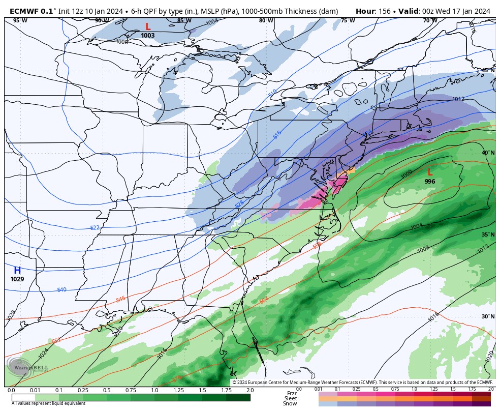
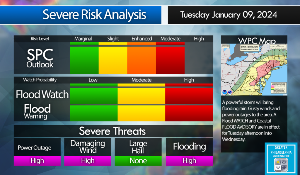
A powerful storm will be 2-3″ upwards of 4″ to the area starting early afternoon on Tuesday into Wednesday. The Philadelphia area will see 40-50 mph winds with gust to 60 mph. Shore points could see wind gust over 65 mph. This storm will cause localized flooding. Expect power outages.
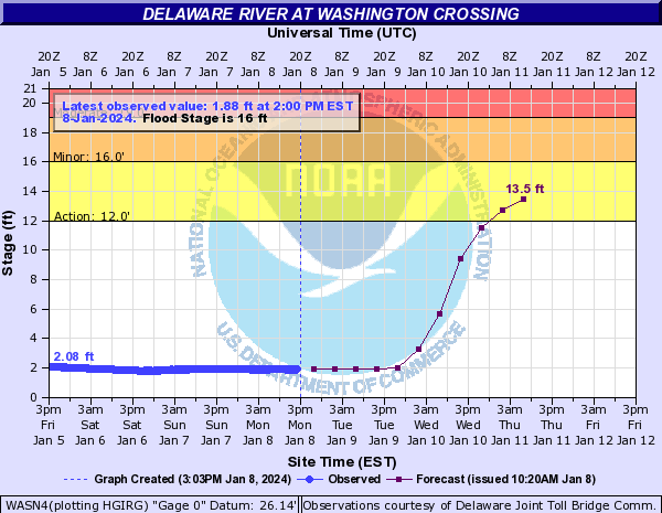
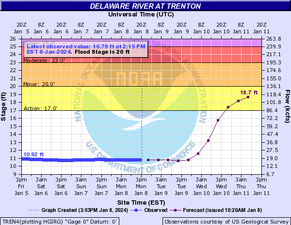
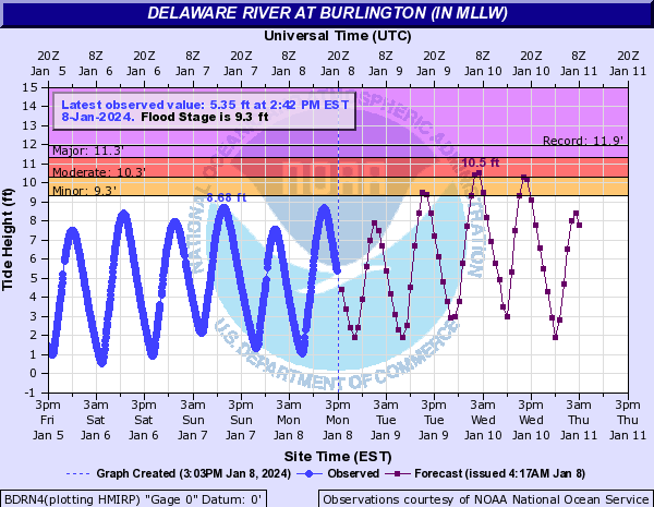
The following are the projected RIVER FLOOD STAGE for The Delaware at Washington Crossing, Trenton and Burlington.
Flood Stage
Watches and Warnings: WIND ADVISORY:
WIND ADVISORY IN EFFECT FROM 5 PM TUESDAY TO 3 AM EST WEDNESDAY.
WHEN…From 5 PM Tuesday to 3 AM EST Wednesday.
IMPACTS…Gusty winds could blow around unsecured objects. Tree limbs could be blown down and a few power outages may result.
ADDITIONAL DETAILS… Saturated ground after multiple rounds of heavy rainfall over the last month has made trees more vulnerable to becoming uprooted with strong winds.
PRECAUTIONARY/PREPAREDNESS ACTIONS... Use extra caution when driving, especially if operating a high profile vehicle. Secure outdoor objects.
FLOOD WATCH IN EFFECT FROM TUESDAY AFTERNOON THROUGH WEDNESDAY AFTERNOON. WHEN… From Tuesday afternoon through Wednesday afternoon.
IMPACTS… Excessive runoff may result in flooding of rivers, creeks, streams, and other low-lying and flood-prone locations. *
ADDITIONAL DETAILS – Rainfall of 1 to 3 inches possible Tuesday through early Wednesday, with the heaviest rain falling Tuesday night. The ground remains very saturated following multiple rounds of heavy rainfall over the last month. A period of higher hourly rainfall rates is possible during Tuesday night which would enhance the potential for flooding, particularly in the urban areas. Tidal inundation combined with runoff in coastal areas may significantly elevate the flood risk, especially if occurring during times of high tide.
COASTAL FLOOD WATCH IN EFFECT FROM TUESDAY EVENING THROUGH LATE TUESDAY NIGHT…
WHERE... In New Jersey, Mercer, Gloucester, Camden and Northwestern Burlington. In Pennsylvania, Delaware, Philadelphia and Lower Bucks. * WHEN…From Tuesday evening through late Tuesday night.
IMPACTS… At this level, widespread roadway flooding occurs along tidal waterways. Some roads become impassable. Minor damage to vulnerable structures may begin to occur.
ADDITIONAL DETAILS. Tidal flooding could be significantly enhanced by an influx of fresh water runoff due to heavy rain Tuesday night.
PRECAUTIONARY/PREPAREDNESS ACTIONS… If travel is required, allow extra time as some roads may be closed. Do not drive around barricades or through water of unknown depth. Take the necessary actions to protect flood-prone property
Today is a weather alert day! Damaging winds, heavy rain will lead to flooding and power outages.
Tuesday
Rain, mainly after 2pm. High near 51. Breezy, with an east wind 5 to 10 mph increasing to 15 to 20 mph in the afternoon. Chance of precipitation is 90%. New precipitation amounts between a half and three quarters of an inch possible.
Tuesday Night
Rain. The rain could be heavy at times. Low around 47. Windy, with a southeast wind 25 to 30 mph, with gusts as high as 45 mph. Chance of precipitation is 100%. New precipitation amounts between 1 and 2 inches possible
Have a great weekend. SNOW Rain and a MIx for eveyone. Snow amounts will be very light. Significant rain storm Tuesday and Wednesday.
Saturday
A chance of snow before 2pm, then rain, possibly mixed with snow. High near 40. Light southeast wind becoming east 10 to 15 mph in the morning. Chance of precipitation is 100%. Little or no snow accumulation expected.
Saturday Night
Rain, possibly mixed with snow, becoming all rain after 7pm. Low around 35. North wind around 15 mph, with gusts as high as 30 mph.
Sunday
Rain likely before 1pm. Cloudy, with a high near 39. West wind around 10 mph. Chance of precipitation is 60%. Little or no snow accumulation expected.
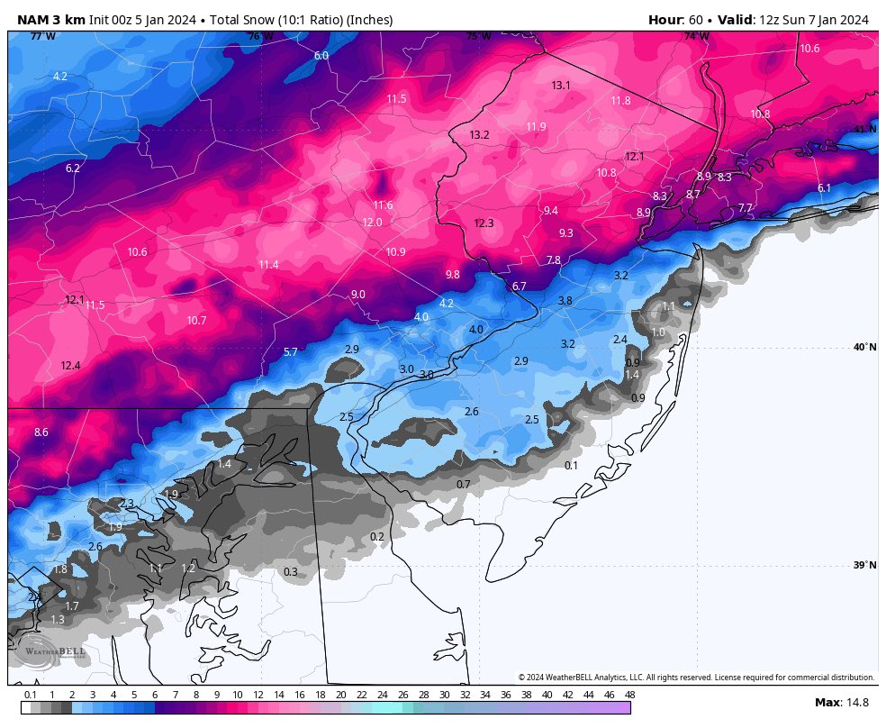
A Winter Storm will bring snow, rain and a mix to the area. This will start Saturday Afternoon into Sunday. At this point the i95 corridor is going to be close to where the rain/snow line set up. I will say at this point the area could see inches or snow or just a little due to placement of the rain/snow line.
Team SNOW is not going to like our call but things could be trending south, which would bring more snow to the area. This will be a HEAVY WET snow!
First Call:
Lower Bucks, Central Bucks, Philly, Trenton – C-2″ Snow changing to Rain/Mix
Doylestown, Reading, Lancaster – 3-6″ Snow changing to Rain/Mix
Quakertown, Allentown, Harrisburg, Pottsville – 4-8″ Heavy wet snow.
All snow will be a wet heavy snow. The NAM above is trending south will this keep up on the overnight runs? We will watch closely and if I need to update the numbers below I will in our second call around mid day tomorrow.
Please NOTE: New Model guidance coming in from the NAM model shows that the storm is trending south. If this keeps up in the overnight models we will be RAISING snow totals for most of the area around the i95 corridor. We are going to keep close eye on this as well as dynamics. I will update late morning with second call if needed.