On Sunday afternoon a week before the Super Bowl featuring the PHILADELPHIA EAGLES and Kansas City Chiefs. Kirk Kelly who is the founder of Greater Philadelphia Severe Weather joined Diehard Philadelphia Eagles fans from the “ Bleeding Green Las Vegas group” on Las Vegas Blvd for a group photo in front of the famous Welcome to Las Vegas Sign.
A group of about 40 birds fans showed up decked head to toe in all shades of Green. Folks I’ve talked to were from all areas of the Delaware valley including Siuth Philly, Montco, and of course Bucks County that have since relocated to Vegas. We are pumped and ready for next week’s Super Bowl said one youngester. As folks were in line everyone was talking about favorite Philly sports places to watch and party for the game and sharing stories from where we were all from!
Las Vegas area Philadelphia Eagles fans come together for a group photo to show support leading up to the Super Bowl
A lot of “GO BIRDS” were yelled! The Eagles will face the AFC Champion Kansas City Chiefs next Sunday in Super Bowl LIX
Mayor Parker stated 6 souls killed from the plane, and at least one person has been killed from a vehicle on the ground. Those numbers will rise. At least 19 people have been treated at local hospitals. Support from local all the way to The White House have been in contact with the mayor and Investigators on scene. Please avoid the area.
10:45pm UPDATE: Shriners Children’s Philadelphia confirmed one of their pediatric patients who was returning to Mexico, along with her mother, were among the six people on board a medical jet that crashed.
9:50 update: per Mayor Parker if you see any debris call 911 so investigators can secure evidence, shelter is available Samuel Fels High School 5500 Langdon St. NTSB, FAA, state local and federal officers are on the scene.
Gov. Josh Shapiro “We saw the best of Philly, neighbors helping neighbors” 45 Pa State Troopers on the ground at the scene. Members of PennDot, DEP and other federal agencies are on site. Shapiro has spoken to US Sec of Transportation Duffy who has members of the FAA and NTSB enroute to Philly at this time.
President Trump made a statement thanking the first responders.
8:00 pm- THE FAA has released the following statement: FAA Statement This information is preliminary and subject to change. A Learjet 55 crashed around 6:30 p.m. local time on Friday, Jan. 31, after departing from Northeast Philadelphia Airport. There were two people on board. The plane was en route to Springfield- Branson National Airport in Missouri. The FAA and NTSB will investigate. The NTSB will lead the investigation and will provide all updates. • Contact local authorities for the names and medical conditions of the people on board.
7:30 pm – The Jet is a medical transport jet. A LeerJet55. That took off from Northeast Philadelphia airport heading to MO. At least 2 people were on board
6:50 pm – Per Police Radio, Human Remains have been found in one of the buildings. Could be the pilot.
Original Story:
After 6pm Friday evening, Emergency crews were responding to a report of an explosion in Northeast Philadelphia after a plane crashed in the area of Roosevelt Boulevard and Cottman Avenue.
Multiple casualties have been reported, It is reported that two people were on the plane.
Multiple homes are on fire in the area of Cottman Avenue and Roosevelt Boulevard following the crash, fire officials said.
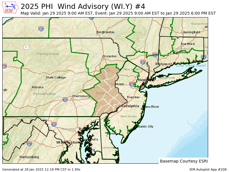
WIND ADVISORY IN EFFECT FROM 9 AM TO 6 PM EST WEDNESDAY...

* WHAT...West winds 15 to 25 mph with gusts up to 50 mph expected.

* WHERE...Portions of east central, northeast, and southeast
  Pennsylvania.

* WHEN...From 9 AM to 6 PM EST Wednesday.

* IMPACTS...Gusty winds will blow around unsecured objects. Tree
  limbs could be blown down and a few power outages may result.

PRECAUTIONARY/PREPAREDNESS ACTIONS...

Winds this strong can make driving difficult, especially for high
profile vehicles. Use extra caution.
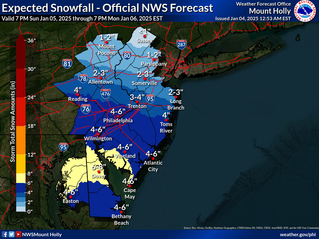
* WHAT...Heavy snow expected. Total snow accumulations between 4 and
  6 inches.

* WHERE...Delaware, Eastern Montgomery, Lower Bucks, and
  Philadelphia Counties.

* WHEN...From 10 AM this morning to 1 AM EST Monday.

* IMPACTS...Travel could be very difficult. Areas of blowing snow
  could significantly reduce visibility.

* ADDITIONAL DETAILS...The precipitation may begin as a mix of some
  light rain and snow with even some sleet before changing to all
  snow closest to Interstate 95. Snowfall rates to an inch per hour
  should develop at times this afternoon. Temperatures are expected
  to fall well below freezing tonight and remain there for several
  days. As a result, icy and slippery conditions may persist even
  after precipitation has ended.

PRECAUTIONARY/PREPAREDNESS ACTIONS...

If you must travel, keep an extra flashlight, food, and water in
your vehicle in case of an emergency. The latest road conditions for
the state you are calling from can be obtained by calling 5 1 1.
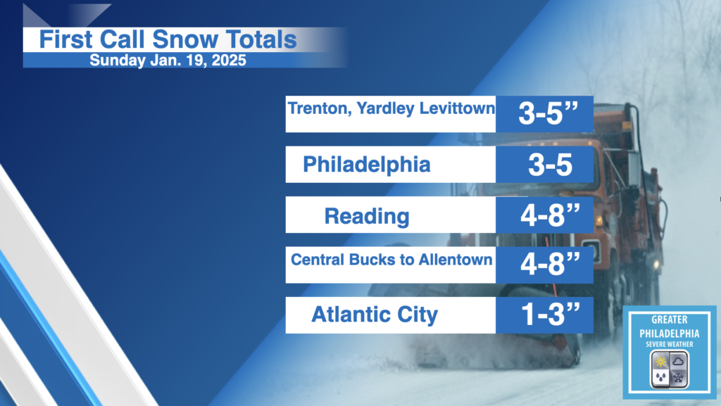
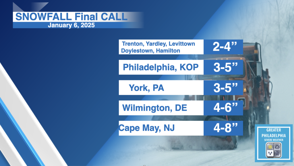
A Winter Storm will bring a general 3-5″ of snow across MOST of the area. Some locations could see locally higher amounts with totals potentially ranging from 4-8″. If you are going to the Eagles game, prepare for heavy snow during the WHOLE GAME. Also make sure you pack a snow shovel, ice scraper. Batter charger, Phone charger, blankets, and water in your car.
TIMING
8:00 AM-Noon: Snow moves into the area
2:00 PM-8:00 PM: Heaviest snow with snowfall rates exceeded 1″ / hr in some areas.
10:00 pm – Midnight: Storm will exit off the coast, with some light snow showers overnight.
SNOW TOTALS: If you live within a few miles of a location listed below, figure those totals for you as well. A General 3-5″ across most of the i95 area. More snow north and west.
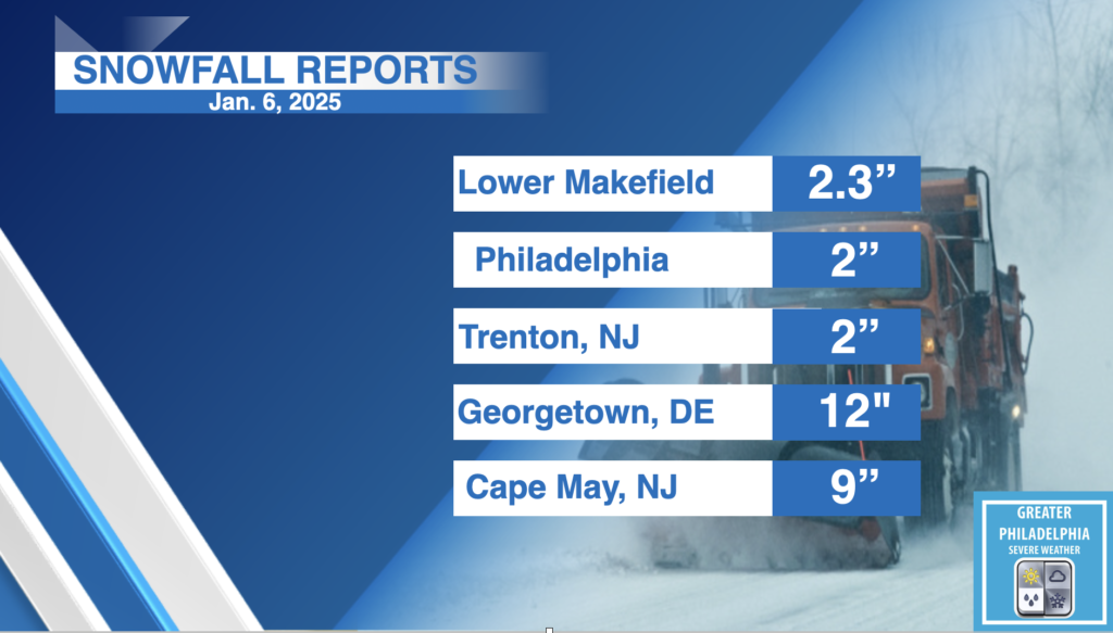
UPDATED SNOWFALL REPORTS FROM JANUARY 6TH AS OF 4 PM from the NWS!
Location Amount Time/Date Provider
...Delaware...
...Kent County... Houston 8.8 in 0150 PM 01/06 Trained Spotter Felton 8.5 in 0200 PM 01/06 Trained Spotter 1 N Milford 8.5 in 0350 PM 01/06 Trained Spotter Felton 8.0 in 1215 PM 01/06 Public 1 E Harrington 7.7 in 0401 PM 01/06 Mesonet 3 SW Magnolia 7.4 in 0321 PM 01/06 Trained Spotter 2 NW Woodside 7.3 in 0346 PM 01/06 Public 1 ESE Woodside 7.0 in 1253 AM 01/06 Trained Spotter Houston 7.0 in 1119 AM 01/06 Trained Spotter 2 SE Frederica 6.9 in 0359 PM 01/06 Mesonet 4 S Hazlettville 6.4 in 0401 PM 01/06 Mesonet Frederica 6.4 in 0935 AM 01/06 Public 2 NW Woodside 6.0 in 1010 AM 01/06 Public Dover 5.6 in 1110 AM 01/06 Public 2 SE Dover 5.5 in 0400 PM 01/06 Mesonet West Dover 5.4 in 0400 PM 01/06 Mesonet 3 SW Magnolia 5.1 in 1000 AM 01/06 Trained Spotter Kenton 5.0 in 0938 AM 01/06 Public Dover Air Force Base 5.0 in 1055 AM 01/06 AWOS Cheswold 4.1 in 1015 AM 01/06 Public 1 ESE West Dover 4.0 in 1000 AM 01/06 Public 2 S Smyrna Landing 3.2 in 0100 PM 01/06 Mesonet
...New Castle County... 2 NE Blackbird 3.2 in 0357 PM 01/06 Mesonet 2 SSE Mount Pleasant 3.0 in 1226 PM 01/06 Broadcast Media 1 E Glasgow 2.7 in 0355 PM 01/06 Mesonet Port Penn 2.6 in 0100 PM 01/06 Mesonet New Castle County Airport 2.2 in 0100 PM 01/06 ASOS Stockton 2.1 in 0358 PM 01/06 Mesonet White Clay Creek 2.1 in 0100 AM 01/06 Mesonet Hockessin 2.0 in 0200 PM 01/06 Trained Spotter 1 SW West Park 2.0 in 0356 PM 01/06 Mesonet Wilmington Manor 2.0 in 1148 AM 01/06 Public 1 SSE Newark 2.0 in 0100 PM 01/06 Mesonet 1 NE Henry Clay 1.8 in 0230 PM 01/06 Broadcast Media Monroe Park 1.6 in 0358 PM 01/06 Mesonet Middletown 1.5 in 0700 AM 01/06 Public Winterthur 1.4 in 0100 PM 01/06 Mesonet Hockessin 1.4 in 0100 PM 01/06 Mesonet Worthland 1.2 in 0355 PM 01/06 Mesonet
...Sussex County... 3 N Delaware Coastal Airport 12.0 in 0200 PM 01/06 Public Georgetown 12.0 in 0342 PM 01/06 Public 1 E Bridgeville 10.0 in 1219 PM 01/06 Amateur Radio 1 N Milton 9.8 in 0210 PM 01/06 Public Bethel 9.8 in 1245 PM 01/06 Broadcast Media 2 WSW Long Neck 9.6 in 0100 PM 01/06 Trained Spotter 1 W Georgetown 9.5 in 1210 PM 01/06 Amateur Radio 1 WNW Lewes 9.4 in 0358 PM 01/06 Mesonet Nassau 9.3 in 0100 PM 01/06 Mesonet Ellendale 9.3 in 0359 PM 01/06 Mesonet 2 N Bridgeville 9.3 in 0402 PM 01/06 Mesonet Stockley 9.2 in 0401 PM 01/06 Mesonet Millville 9.0 in 1200 PM 01/06 Public Laurel 9.0 in 0309 PM 01/06 Public Lewes 9.0 in 1200 PM 01/06 Public 2 E Seaford 9.0 in 1219 PM 01/06 Public 5 W Seaford 8.4 in 0400 PM 01/06 Mesonet 1 E Millville 8.2 in 0920 AM 01/06 Public 2 SE Bridgeville 8.0 in 0900 AM 01/06 Public 1 E Selbyville 8.0 in 1200 PM 01/06 Trained Spotter Delmar 8.0 in 1230 PM 01/06 Trained Spotter Milford 8.0 in 0130 PM 01/06 Public 1 SE Dagsboro 7.8 in 0359 PM 01/06 Mesonet 1 NNW Bethany Beach 7.0 in 0100 AM 01/06 Mesonet Dagsboro 7.0 in 0900 AM 01/06 Public 2 WSW Laurel 6.9 in 0358 PM 01/06 Mesonet 1 WNW Seaford 6.0 in 0800 AM 01/06 Trained Spotter Delmar 5.5 in 0600 AM 01/06 Cocorahs Long Neck 5.1 in 0841 AM 01/06 Public 4 ENE Delmar 5.0 in 0715 AM 01/06 Cocorahs 3 WSW Georgetown 4.7 in 0730 AM 01/06 Trained Spotter Ellendale 3.0 in 0500 AM 01/06 Public
...Maryland...
...Caroline County... Preston 12.0 in 0253 PM 01/06 Public 4 SSE Ingleside 7.0 in 0145 PM 01/06 Trained Spotter 1 WSW American Corner 4.0 in 0600 AM 01/06 Broadcast Media
...Kent County... Rock Hall 5.0 in 1140 AM 01/06 Trained Spotter
...Queen Annes County... Stevensville 8.0 in 1100 AM 01/06 Trained Spotter 2 SSW Chester 8.0 in 1100 AM 01/06 Public 2 SSW Carville 7.0 in 0115 PM 01/06 Emergency Mngr 2 WSW Chester 6.5 in 1215 PM 01/06 Public 2 SW Chester 5.0 in 0750 AM 01/06 Public Chester 3.5 in 0545 AM 01/06 Public
...Talbot County... Easton 11.5 in 1230 PM 01/06 Public Royal Oak 6.0 in 1052 AM 01/06 Trained Spotter
...New Jersey...
...Atlantic County... 2 NE Ventnor City 7.0 in 1021 AM 01/06 Public 1 NNE Ventnor City 6.8 in 1035 AM 01/06 Public Atlantic City 5.5 in 1047 AM 01/06 Public 1 WSW Margate City 5.5 in 1056 AM 01/06 Public 1 N Northfield 5.0 in 0100 PM 01/06 Amateur Radio Somers Point 4.5 in 0110 PM 01/06 Public 1 SE Egg Harbor City 4.0 in 0100 PM 01/06 Trained Spotter 1 NW Somers Point 4.0 in 0301 PM 01/06 Cocorahs Atlantic City International 4.0 in 0100 PM 01/06 ASOS 1 E Estell Manor 3.7 in 0100 PM 01/06 Trained Spotter Egg Harbor Twp 3.1 in 1200 PM 01/06 Trained Spotter Mays Landing 3.0 in 0900 AM 01/06 Trained Spotter 2 WSW Richland 3.0 in 1230 PM 01/06 Public Hammonton 2.0 in 0100 PM 01/06 Trained Spotter 1 N Hammonton 1.5 in 1230 PM 01/06 CO-OP Observer 1 SE Absecon 0.5 in 0700 AM 01/06 Trained Spotter
...Burlington County... Leisuretowne 1.9 in 0111 PM 01/06 Trained Spotter Willingboro 1.8 in 0123 PM 01/06 Public 1 ESE Moorestown 1.5 in 0100 PM 01/06 Trained Spotter 2 NW South Jersey Regional A 1.4 in 0130 PM 01/06 NWS Employee Mount Holly WFO 1.4 in 0100 PM 01/06 Official NWS Obs 1 SSE Rancocas 1.3 in 0110 PM 01/06 NWS Employee 2 NNW South Jersey Regional 1.2 in 1245 PM 01/06 CO-OP Observer Columbus 1.0 in 1035 AM 01/06 Trained Spotter Burlington 1.0 in 1100 AM 01/06 Public Fort Dix 1.0 in 1204 PM 01/06 Public Whitesbog 0.5 in 0930 AM 01/06 Trained Spotter
...Camden County... 1 E Laurel Springs 1.5 in 0130 PM 01/06 Trained Spotter Lindenwold 1.2 in 0113 PM 01/06 Amateur Radio Somerdale 1.2 in 0113 PM 01/06 Amateur Radio Atco 1.2 in 0113 PM 01/06 Amateur Radio Winslow Twp 1.2 in 0113 PM 01/06 Amateur Radio 2 NNE Gibbsboro 1.0 in 0915 AM 01/06 Public Cherry Hill Twp 0.3 in 0900 AM 01/06 Public
...Cape May County... 2 NW Cape May 8.1 in 0100 PM 01/06 CO-OP Observer Cape May 8.0 in 0221 PM 01/06 Public 1 WSW Ocean City 7.4 in 1038 AM 01/06 Public Rio Grande 7.0 in 0115 PM 01/06 Trained Spotter Stone Harbor 6.5 in 0124 PM 01/06 Public 1 NE Ocean City 5.0 in 0100 PM 01/06 Amateur Radio Ocean City 5.0 in 0230 PM 01/06 Public 1 S Lower Twp 5.0 in 0900 AM 01/06 Public 1 W Marmora 4.9 in 0200 PM 01/06 Public Rio Grande 3.5 in 0835 AM 01/06 Trained Spotter
...Cumberland County... 1 S Newfield 4.0 in 0100 PM 01/06 Amateur Radio Vineland 3.8 in 0246 PM 01/06 Public Vineland 3.8 in 0347 PM 01/06 Trained Spotter Millville 3.5 in 0348 PM 01/06 Trained Spotter 2 N Vineland 2.8 in 0312 PM 01/06 Trained Spotter Vineland 2.6 in 1003 AM 01/06 Public Upper Deerfield Twp 2.5 in 0347 PM 01/06 Trained Spotter
...Gloucester County... Malaga 3.0 in 0200 PM 01/06 Trained Spotter Malaga 2.5 in 0352 PM 01/06 Trained Spotter 1 W Pitman 2.0 in 0140 PM 01/06 Trained Spotter 1 W Pitman 1.8 in 0228 PM 01/06 Cocorahs Pitman 1.6 in 0226 PM 01/06 Trained Spotter Woodbury 1.5 in 0100 PM 01/06 Trained Spotter Washington Twp 1.4 in 0110 PM 01/06 Trained Spotter
...Hunterdon County... 2 NW Three Bridges 1.1 in 0145 PM 01/06 Trained Spotter Whitehouse Station 0.8 in 1227 PM 01/06 Public
...Mercer County... Trenton Mercer Airport 1.8 in 0100 PM 01/06 ASOS 1 NNE Hamilton Square 1.7 in 0115 PM 01/06 Trained Spotter Pennington 1.5 in 1200 PM 01/06 Amateur Radio Yardville 1.4 in 1231 PM 01/06 Public Princeton Junction 1.4 in 0100 PM 01/06 Trained Spotter 1 WNW Hamilton Square 1.3 in 0252 PM 01/06 Trained Spotter 1 S Trenton Mercer Airport 1.3 in 1256 PM 01/06 Trained Spotter Hamilton Square 1.0 in 1200 PM 01/06 Amateur Radio Hopewell 1.0 in 1200 PM 01/06 Amateur Radio
...Middlesex County... Cranbury 1.3 in 0300 PM 01/06 Other Federal Cheesequake 1.3 in 0349 PM 01/06 Trained Spotter South River 1.0 in 0150 PM 01/06 Trained Spotter Woodbridge 1.0 in 0355 PM 01/06 Trained Spotter North Brunswick Twp 1.0 in 0112 PM 01/06 Public 1 NW Concordia 1.0 in 0120 PM 01/06 Trained Spotter Metuchen 1.0 in 0130 PM 01/06 Trained Spotter 1 NNE Concordia 0.5 in 1200 PM 01/06 Amateur Radio
...Monmouth County... 1 SW Freehold 2.2 in 0200 PM 01/06 Trained Spotter Freehold 2.0 in 1155 AM 01/06 Trained Spotter 1 NNW Clarksburg 1.8 in 0300 PM 01/06 Cocorahs 2 WSW Farmingdale 1.8 in 1145 AM 01/06 Public 2 WSW Farmingdale 1.4 in 0130 PM 01/06 Trained Spotter Leonardo 1.1 in 0225 PM 01/06 Public Keyport 0.8 in 0324 PM 01/06 Trained Spotter 1 SW Long Branch 0.1 in 0845 AM 01/06 CO-OP Observer
...Morris County... 2 ESE Randolph 0.7 in 0300 PM 01/06 Cocorahs 1 SW Netcong 0.5 in 0100 PM 01/06 Trained Spotter Green Pond 0.5 in 0100 PM 01/06 Trained Spotter Chatham 0.3 in 0332 PM 01/06 Public
...Ocean County... Barnegat 1.4 in 0200 PM 01/06 Trained Spotter Point Pleasant Beach 1.4 in 0309 PM 01/06 Trained Spotter 3 N Ocean Gate 1.4 in 0102 PM 01/06 Public 1 S Bayville 1.2 in 0100 PM 01/06 Trained Spotter Brick 1.2 in 0145 PM 01/06 Trained Spotter 1 SSE Stafford Twp. 1.0 in 0145 PM 01/06 Trained Spotter Jackson 1.0 in 0304 PM 01/06 Trained Spotter Forked River 1.0 in 1000 AM 01/06 Trained Spotter 2 ESE Ramtown 1.0 in 1200 PM 01/06 Trained Spotter 1 WNW Point Pleasant 1.0 in 0100 PM 01/06 Trained Spotter
...Salem County... Pennsville 2.0 in 0200 PM 01/06 Trained Spotter
...Somerset County... 2 ENE Montgomery Twp 1.0 in 0100 PM 01/06 Trained Spotter 2 N Bridgewater 1.0 in 0100 PM 01/06 Trained Spotter
...Sussex County... 1 SW High Point 0.5 in 1140 AM 01/06 Trained Spotter
...Warren County... Stewartsville 1.0 in 0200 PM 01/06 Trained Spotter 1 SSW Washington 0.8 in 1230 PM 01/06 Trained Spotter Blairstown Twp 0.7 in 1255 PM 01/06 Cocorahs Hackettstown 0.7 in 0120 PM 01/06 Trained Spotter Hackettstown 0.4 in 1225 PM 01/06 Trained Spotter
...Pennsylvania...
...Berks County... Earl Twp 1.5 in 0100 PM 01/06 Trained Spotter Reading Regional Airport 1.5 in 0100 PM 01/06 ASOS Spring Twp 1.5 in 0104 PM 01/06 Public Huffs Church 1.4 in 1115 AM 01/06 Trained Spotter 1 E Birdsboro 1.4 in 1130 AM 01/06 Public 1 NE Sinking Spring 1.0 in 1015 AM 01/06 Public
...Bucks County... Lower Makefield Twp 2.3 in 0117 PM 01/06 Public 1 W Bensalem 2.1 in 0232 PM 01/06 Public 1 NW Tullytown 2.0 in 0130 PM 01/06 Trained Spotter 1 NNW Langhorne 1.8 in 1250 PM 01/06 Trained Spotter 1 SE Furlong 1.6 in 0145 PM 01/06 Trained Spotter 1 NNW East Rockhill Twp 1.6 in 1245 PM 01/06 Trained Spotter Lower Southampton Twp 1.5 in 0215 PM 01/06 Trained Spotter Trumbauersville 1.5 in 1107 AM 01/06 Trained Spotter Warminster 1.5 in 1200 PM 01/06 Trained Spotter 1 SSE Northampton Twp 1.5 in 1200 PM 01/06 NWS Employee Bensalem 1.5 in 0114 PM 01/06 Trained Spotter Fricks 1.0 in 0101 PM 01/06 Trained Spotter Langhorne 0.3 in 0900 AM 01/06 Trained Spotter
...Carbon County... Hudsondale 1.0 in 1225 PM 01/06 Public
...Chester County... 1 NW East Nantmeal Twp 2.5 in 1130 AM 01/06 Trained Spotter Berwyn 2.3 in 0302 PM 01/06 Public Berwyn 2.3 in 0333 PM 01/06 Public Jennersville 2.3 in 1245 PM 01/06 Public West Caln Twp 2.1 in 1243 PM 01/06 Trained Spotter Easttown Twp 2.0 in 1045 AM 01/06 Public 1 WSW Phoenixville 1.8 in 0200 PM 01/06 Trained Spotter Exton 1.5 in 0241 PM 01/06 Public Oxford 1.5 in 0922 AM 01/06 Public Chesterbrook 1.5 in 1020 AM 01/06 Public 2 WNW Upper Uwchlan Twp 1.5 in 1124 AM 01/06 Trained Spotter East Coventry Twp 1.3 in 1130 AM 01/06 Trained Spotter North Coventry Twp 1.3 in 1200 PM 01/06 Public
...Delaware County... Aston 1.8 in 0130 PM 01/06 Public Boothwyn 1.8 in 0105 PM 01/06 Public Morton 1.4 in 1200 PM 01/06 Trained Spotter Swarthmore 1.4 in 0130 PM 01/06 Trained Spotter 1 SSW Chelsea 1.0 in 1220 PM 01/06 Public
...Lehigh County... 1 NW Upper Macungie Twp. 2.0 in 0115 PM 01/06 Public Washington Twp 1.6 in 0324 PM 01/06 Trained Spotter Lehigh Valley International 1.2 in 0100 PM 01/06 ASOS Salisbury Twp 1.1 in 0120 PM 01/06 Trained Spotter North Whitehall Twp 0.7 in 1100 AM 01/06 Trained Spotter 1 NNW Schnecksville 0.6 in 1100 AM 01/06 Trained Spotter Macungie 0.5 in 1000 AM 01/06 Trained Spotter
...Monroe County... 1 N Mount Pocono 0.7 in 0108 PM 01/06 Cocorahs
...Montgomery County... 1 SSE Trappe 2.1 in 1230 PM 01/06 Trained Spotter North Wales 1.9 in 1230 PM 01/06 Public Eagleville 1.6 in 1236 PM 01/06 Trained Spotter 1 E Willow Grove 1.5 in 0200 PM 01/06 Trained Spotter Horsham 1.5 in 0236 PM 01/06 Public 1 ESE Hatboro 1.5 in 1205 PM 01/06 Trained Spotter 2 NNE Upper Dublin Twp 1.5 in 0100 PM 01/06 Public 1 ENE Plymouth Twp 1.5 in 0113 PM 01/06 Public 1 ENE New Hanover Twp 1.4 in 1145 AM 01/06 Trained Spotter
...Northampton County... Nazareth 1.2 in 1200 AM 01/06 Public 3 E Moore Twp 0.9 in 0200 PM 01/06 Trained Spotter Hellertown 0.9 in 1240 PM 01/06 Trained Spotter Bushkill Twp 0.8 in 1005 AM 01/06 Trained Spotter Martins Creek 0.8 in 1245 PM 01/06 CO-OP Observer South Easton 0.3 in 0800 AM 01/06 Trained Spotter
...Philadelphia County... Philadelphia Intl Airport 1.8 in 0100 PM 01/06 ASOS 1 WNW Bustleton 1.5 in 0200 PM 01/06 Trained Spotter 1 SSE Center City 1.2 in 0100 PM 01/06 Trained Spotter 1 SSE Center City 1.2 in 0130 PM 01/06 Public 1 S Philadelphia 1.0 in 0130 PM 01/06 Trained Spotter Philadelphia 0.4 in 0900 AM 01/06 Cocorahs
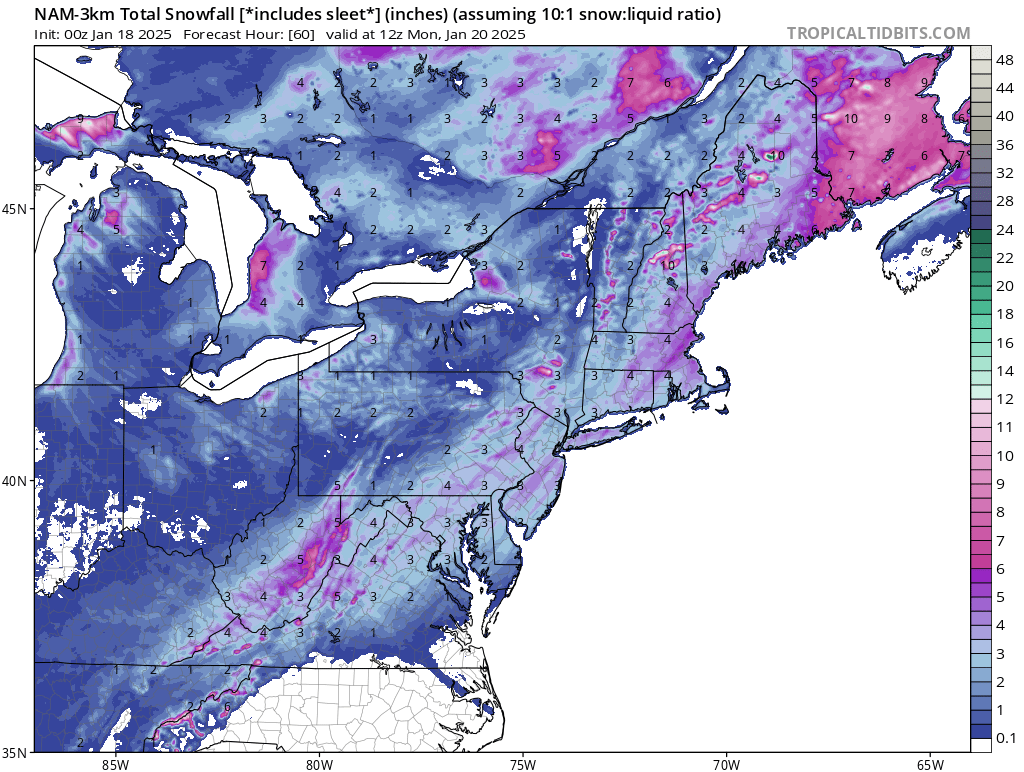
Our biggest snowstorm in the past few years is knocking on our doorstep. Early Monday morning the area will see snow begin to move into the area. The area will see temps below freezing until at last the end of the week. This system will bring more snow to the south, a general 2-5″ of snow will fall across most of the area with pockets of 4-6/4-8″ south of Philly. A tick north could raise the totals a little higher. We are also keeping an eye on the system for next weekend which could bring plowable snow to EVERYONE! But one system at a time.
TIMING: Snow will move into the area Early Monday morning and start to taper off late Monday afternoon/ early evening. The warnings and advisories will go into effect at 1am
SNOW AMOUNTS:
FINAL CALL SNOW TOTALS: A general 2-5″ will fall across most of the area with localized higher amounts. We do expect to see higher amounts to the south.
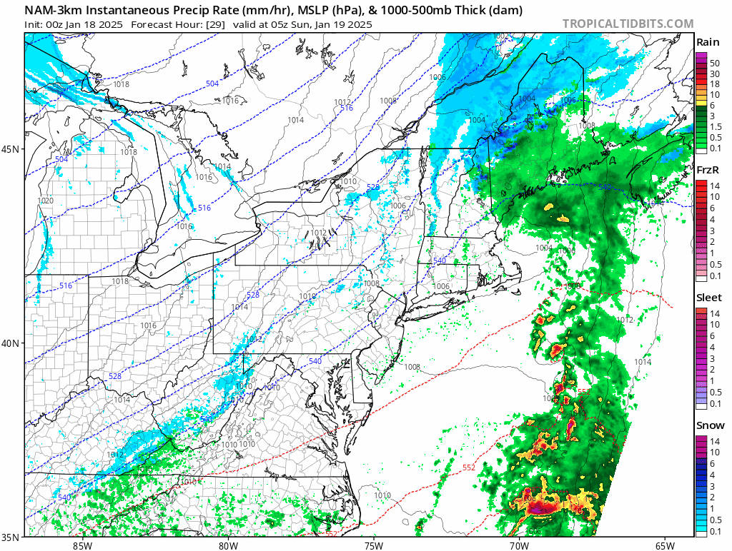
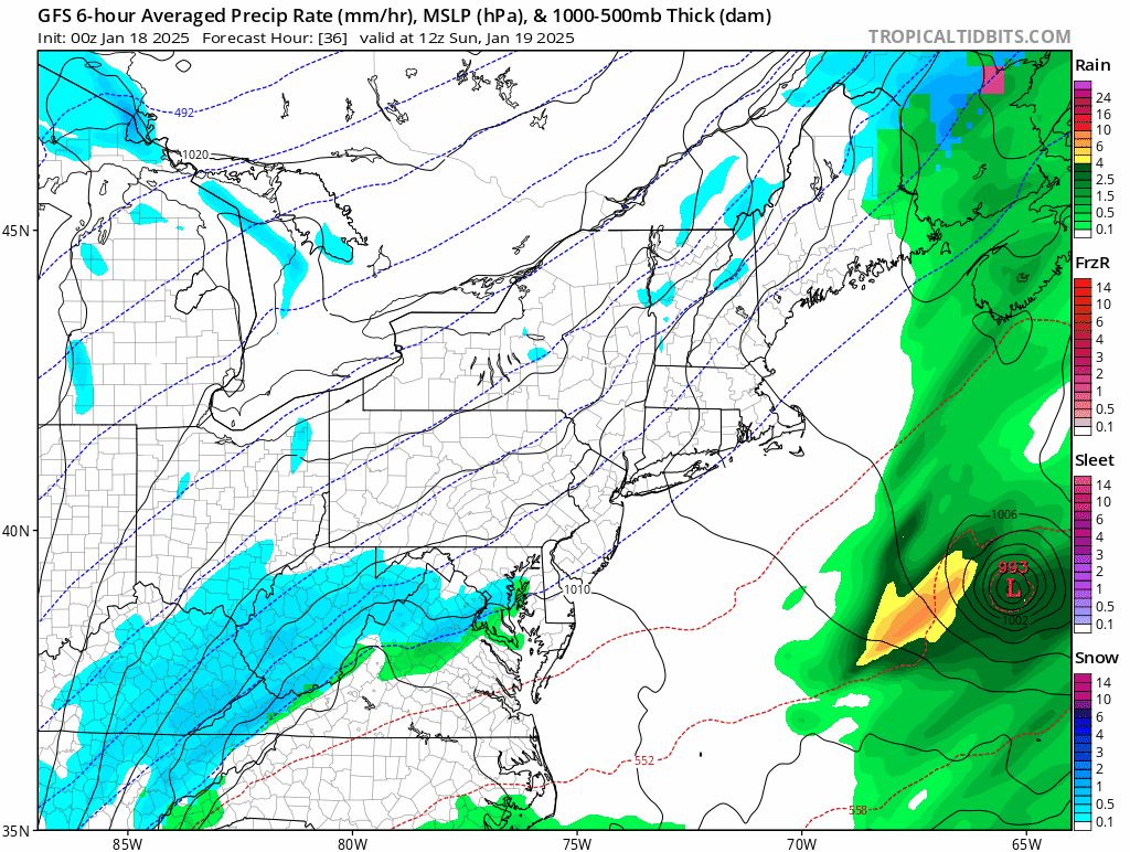
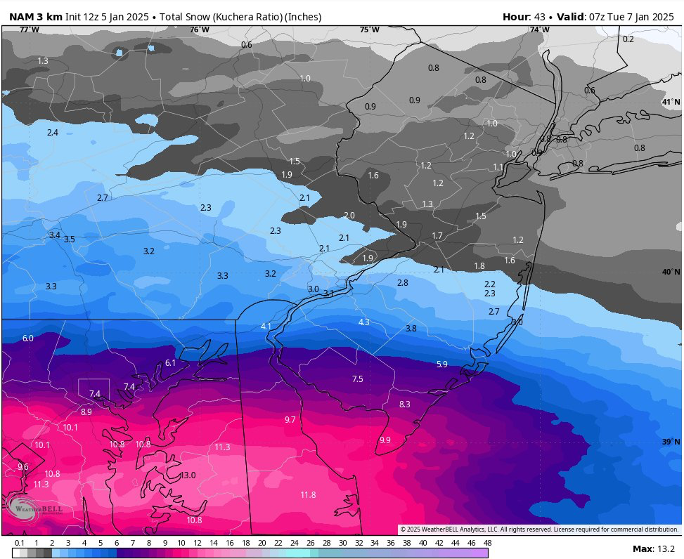
HERE is the latest NAM from Today.
IMPACTS: Widespread accumulating snowfall could create dangerous driving conditions.
Current Radar:
WINTER WEATHER ADVISORY REMAINS IN EFFECT FROM 1 AM TO 10 PM EST MONDAY…
* WHAT…Snow expected. Total snow accumulations between 2 and 4 inches.
* WHERE…Portions of southern New Jersey and east central and southeast Pennsylvania.
* WHEN…From 1 AM to 10 PM EST Monday.
* IMPACTS…Plan on slippery road conditions. The hazardous conditions will impact the Monday morning and evening commutes.
* ADDITIONAL DETAILS…Snow will overspread the region late Sunday night and intensify through Monday morning. It will then gradually taper off Monday afternoon and evening.
PRECAUTIONARY/PREPAREDNESS ACTIONS…
Slow down and use caution while traveling. The latest road conditions for the state you are calling from can be obtained by calling 5 1 1.
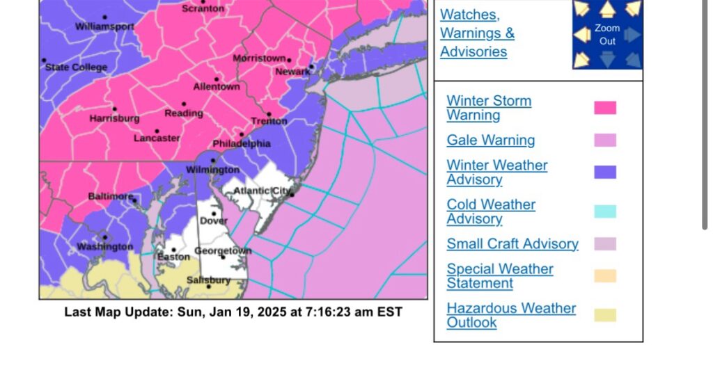
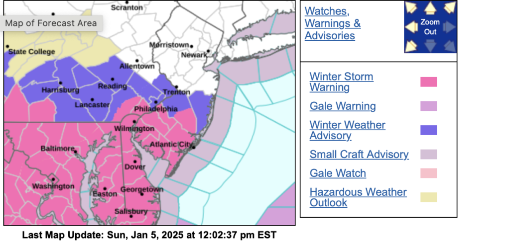
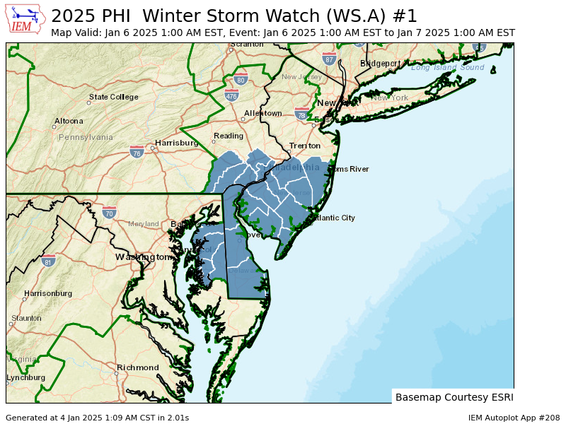
A Winter Storm Watch has been issued for Philadelphia south and east.
WINTER STORM WATCH IN EFFECT FROM LATE SUNDAY NIGHT THROUGH LATE MONDAY NIGHT…
* WHAT…Heavy snow is possible. Total snow accumulations between 3 and 6 inches possible.
* WHERE…Portions of southern New Jersey and southeast Pennsylvania.
* WHEN…From late Sunday night through late Monday night.
* IMPACTS…Travel could be very difficult. The hazardous conditions could impact the Monday morning and evening commutes.
* ADDITIONAL DETAILS…Snow will overspread the region late Sunday night and intensify through midday Monday. It will then gradually taper off Monday night.
PRECAUTIONARY/PREPAREDNESS ACTIONS…
Monitor the latest forecasts for updates on this situation.
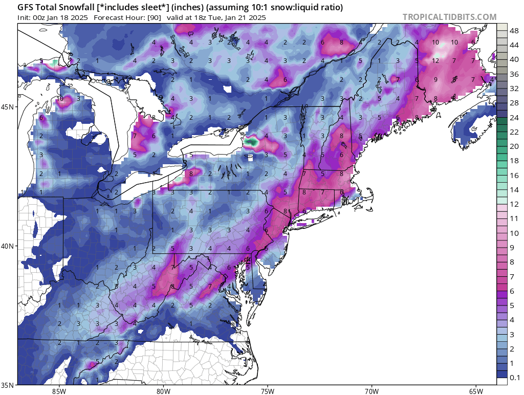
Our biggest snowstorm in the past few years is knocking on our doorstep. Late Sunday night the area will see snow begin to move into the area. As the storm moves out on Monday afternoon locations south of Philly could see some mixing. The area will see temperatures below freezing through at least Friday at this time. Below is our FIRST CALL for this system!
TIMING: Snow will move into the area Late Sunday and start to taper off late Monday afternoon/ early evening.
SNOW AMOUNTS:
FIRST CALL SNOW TOTALS. We will release a second and finaly snowfall map late Saturday/Early Sunday. A general 3-6″ will fall across most of the area with localized higher amounts. We do expect to see higher amounts for some areas.
IMPACTS: Widespread accumulating snowfall could create dangerous driving conditions. We expect that schools will be closed on Monday for much of the area. Let the kids have a SNOW day and not a “online school”